
Ribnik (river)
| Ribnik | |
|---|---|
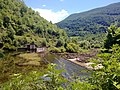
 Fly fishing on the Ribnik river. | |
 | |
 Location of the Ribnik's confluence with the Sana | |
| Location | |
| Country | Bosnia and Herzegovina |
| Municipality | Ribnik (Western Bosnia and Herzegovina) |
| Physical characteristics | |
| Source | |
| • location | Solići hamlet, Gornji Ribnik village |
| • coordinates | 44°24′08″N 16°48′02″E / 44.4023133°N 16.8004856°E |
| • elevation | 300 m (980 ft) |
| 2nd source | |
| • location | Solići hamlet, Gornji Ribnik village |
| • coordinates | 44°24′13″N 16°47′52″E / 44.4037255°N 16.7977658°E |
| 3rd source | |
| • location | Solići hamlet, Gornji Ribnik village |
| • coordinates | 44°24′12″N 16°47′53″E / 44.4032963°N 16.7981467°E |
| Mouth | Sana river |
• location | Velije hamlet, Gornji Ribnik village |
• coordinates | 44°26′04″N 16°49′33″E / 44.434454°N 16.8257868°E |
| Length | 5.5 km (3.4 mi) [1] |
| Basin size | 447 km2 (173 sq mi) [1] |
| Width | |
| • average | 30 m (98 ft) |
| Depth | |
| • average | 0.5 m (1.6 ft) |
| Discharge | |
| • location | at the springs |
| • average | 15,5 m3/s |
| • minimum | 1,25 m3/s |
| • maximum | ≥100 m3/s |
| Basin features | |
| Progression | Sana→ Una→ Sava→ Danube→ Black Sea |
| River system | Una |
The Ribnik (
Name
The name of the river derives from the Slavic word for fish, riba, from which derives ribnjak or ribnik, a fish pond, a river, or a pool, or a body of water stocked with fish.[2][3][4]
Geography and hydrology
The Ribnik river, just like the Sana in its upper course, is classified mountain river with upland freshwater ecology, with its very clear and cold waters, classified as the Class I (or A) purity. Gushing out of the karst plateau with Ovčara as most prominent summit (1576 m), between Klekovača and Vitorog mountains. The springs of both the river Sana and the Ribnik are located in a municipality of Ribnik, in Bosnia and Herzegovina, Republika Srpska entity (regionally it is a Western Bosnia and Herzegovina), in a wider areal of the villages of Gornji and Donji Vrbljani. The Ribnik basin comprise about 447 square kilometres[5]

Springs
The Ribnik emerges near the small hamlet Solići. The spring group consist of three very strong
The sources of the Ribnik River are about 4 km from the village of Ribnik. The Ribnik River is approximately 8 km long and represents one of the shortest and very rich flows by water, not only in the territory of our Republika Srpska but also in Europe. Its journey ends at the village of Velije where it flows into the River Sanaa. The waters of the Ribnik River belong to the waters of class I.[6]
The Ribnik springs out below the mountain
-
 The Ribnik wellspring - one of two in the upper group.
 -
 The Ribnik wellsprings - confluence of first two in the upper group.
 -
 The Ribnik wellspring - the lower, separate one.

.jpg)

Course
It is a short
Tourism and outdoor recreation

The river Ribnik, together with the Sana, represents a very important tourist potential. Its waters are rich in salamonids fish,
Fly fishing

The Ribnik municipality is known for hunting and fishing, and the fly fishing competitions are held on the River seasonally. The Ribnik is famous and popular throughout the world among fly fishing aficionados as Bosnia's and Europe's prime fly fishing destination, with an abundant brown trout stock, and especially for its trophy sized greyling population.[4][8][9]
Hunting
Hills and mountains in the wider area of the Ribnik are well maintained hunting grounds, with a game feeding grounds. Hunting trails with open and closed type checks, as well as hunting lodges are available. These hunting areas represent a nature reserve used for breeding of wide variety of game, such as
Hiking and caving
.jpg)
Šiša is one of the mountains in this region, adorned with a dense
The Ledena pećina (transl. Ice Cave) is located near the village of
Ambiance and leisure
Ambiental value of a spring areal is important for local tourism too, and have a higher management value than
See also
References
- ^ a b "Sava River Basin Analysis Report" (PDF). International Sava River Basin Commission. September 2009. p. 13. Archived from the original (PDF, 9.98 MB) on 2010-07-17.
- ISBN 978-961-254-016-6. Retrieved 13 December 2021.
- ^ "Fran/iskanje/ribnik". Fran (in Slovenian). Retrieved 13 December 2021.
- ^ a b c "Ribnik - mjesto meditacije, odmora i čistog užitka... (FOTO, VIDEO)". MONDO.BA (in Serbo-Croatian). 12 September 2021. Retrieved 2 December 2021.
- ^ "Strategy - Pilot River Basin Plan for Sava River" (PDF). voda.ba (in Serbo-Croatian). Agencija za vodno područje rijeke Save FBiH. p. 16. Retrieved 3 December 2021.
- ^ a b c d e f g h "Područije rijeke Ribnik". ribnikflyfish.com (in Serbo-Croatian). Archived from the original on 25 October 2017. Retrieved 2 December 2021.
- S2CID 242346730. Retrieved 2 December 2021.
- ^ "Sight fishing on the Ribnik". eat-sleep-fish.co.uk. Eat, Sleep, Fish. Retrieved 7 December 2021.
- ^ "Bosnia and Herzegovina: The Hidden Gem of the Balkan Region". outdooruae.com. OutdoorUAE. 14 March 2019. Retrieved 7 December 2021.
- S2CID 242346730. Retrieved 2 December 2021.

External links
- Bosnia Blue-winged Olive, by Alex Jardine (aardvarkmcleod.com)
- Bosnia, at Fishmaster