
Bosna (river)
| Bosna | |
|---|---|
Bosanski Šamac | |
| Physical characteristics | |
| Source | Vrelo Bosne |
| • location | Igman, Ilidža, Bosnia and Herzegovina |
| • coordinates | 43°49′6.6″N 18°16′11.9″E / 43.818500°N 18.269972°E |
| • elevation | 520 m (1,710 ft);[1] (494.5 m (1,622 ft) a.s.l. according to an earlier source[2]) |
Bosanski Šamac, Bosnia and Herzegovina | |
• coordinates | 45°4′0″N 18°28′1″E / 45.06667°N 18.46694°E |
• elevation | 78 m (256 ft) |
| Length | 281.6 km (175.0 mi)[3] |
| Basin size | 10,810 km2 (4,170 sq mi)[3] |
| Discharge | |
| • average | 174 m3/s (6,100 cu ft/s) |
| Basin features | |
| Progression | Sava→ Danube→ Black Sea |

The Bosna (
The river is possibly mentioned for the first time during the 1st century AD by Roman historian
According to philologist Anton Mayer, the name Bosna could be derived from Illyrian Bass-an-as(-ā), which would be a diversion of the Proto-Indo-European root bʰegʷ, meaning 'the running water'.[8]
Geography and sectioning
The Bosna River has created the Bosna River Valley. The valley has been developed as the country's industrial hub and is home to nearly a million people, who live primarily in several major cities.
Vrelo Bosne and Mala Bosna
The Bosna source is the Vrelo Bosne spring, located at 520 m (1,710 ft) a.s.l.[1] (according to an earlier source, 494.5 m (1,622 ft) a.s.l.[2]) at the foothills of mount Igman, on the outskirts of Sarajevo, capital of Bosnia and Herzegovina.[1] The spring is one of Bosnia and Herzegovina's chief natural landmarks and tourist attractions.[9]
The course between the source and its largest tributary in this section, the Željeznica, which runs in from the right, is referred as the Mala Bosna (transl. Little Bosna), but the section is often extended all the way to its confluence with Miljacka, four kilometers downstream.[10] Its tributaries between the source and the Željeznica are first the Večerica and then Bukulaš, while in the region of extended Mala Bosna course it further receives, first the Željeznica from the right, then approx. 600 meters downstream the Zujevina, the only tributary from the left in this region, followed by the Dobrinja (a.k.a. Tilava) 1.5 km, and then 2 km further the Miljacka, both from the right.[10][11]
Upper Bosna
The Upper Bosna is a section between its source and the mouth of the Lašva, a left tributary, just upstream from Zenica. The section encompasses the entire region between Ilidža, near Sarajevo, and the Lašva, including the spacious valley between Ilijaš and Kakanj. The Visoko region, with its medieval heritage, is at the center of this area.
Middle Bosna
The Middle Bosna is mostly composed of gorges, with steep slopes and narrow passages, between Zenica and Doboj. In this section, there are several medieval sites, such as Vranduk, Maglaj and Doboj.
Lower Bosna
The Lower Bosna is the last section of the Bosna. From Doboj, the river continues northwards, approaching the
Course and tributaries
The Bosna flows through a number of cantons. From its starting point in the

The main right tributaries are: Željeznica, Miljacka, Ljubina, Misoča, Stavnja, Trstionica, Zgošća, Gostović, Krivaja and Spreča. On the left, the main tributaries are: Zujevina, Fojnica, Lašva and Usora.
-
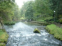 Vrelo Bosne, source of the river just outside Sarajevo
 -
 One of the ponds on Vrelo Bosne in Ilidža
 -
 Mala Bosna river in Ilidža
 -
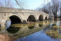 Roman bridge over Mala Bosna river in Ilidža
 -
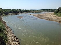 The Lower Bosna nearBosanski Šamac
.JPG)

.JPG)


References
- ^ a b c PLAN UPRAVLJANJA SPOMENIKOM PRIRODE VRELO BOSNE 2020-2030 (PDF). p. 25. Retrieved 14 November 2023.
- ^ a b Aganović M. (1965). "Komparativna istraživanja režima ishrane, rasta, plodnosti i strukture populacija lipljena u rijekama Bosni i Plivi". Godišnjak - The Annual of the Institute of Biology. 18. Institute of Biology - PMF University of Sarajevo: 5. Retrieved 14 November 2023.
- ^ a b c "Sava River Basin Analysis Report" (PDF). International Sava River Basin Commission. September 2009. p. 13. Archived from the original (PDF, 9.98 MB) on 2010-07-17.
- ^ Šašel Kos, M.; P. Kos. "Places: 197162 (Bathinus (river))". Pleiades. Retrieved January 22, 2017.
- ISBN 9789958031106.
- ^ Velleius Paterculus, Historia Romana 2.114.4.6 http://latin.packhum.org/loc/1044/1/131/1509-1516
- ^ Salmedin Mesihović (2010). Aevvm Dolabellae – Dolabelino Doba. Vol. XXXIX. Sarajevo: Centar za balkanološka ispitivanja, Akademija nauka i umjetnosti. p. 10.
- ^ Indira Šabić (2014). Onomastička analiza bosanskohercegovačkih srednjovjekovnih administrativnih tekstova i stećaka (PDF). Osijek: Sveučilište Josipa Jurja Strossmayera. p. 165. Archived from the original (PDF) on 2017-01-14. Retrieved 2015-03-30.
- ^ PLAN UPRAVLJANJA SPOMENIKOM PRIRODE VRELO BOSNE 2020-2030 (PDF). pp. 9–53. Retrieved 14 November 2023.
- ^ a b Aganović M. (1965). "Komparativna istraživanja režima ishrane, rasta, plod nosti i strukture populacija lipljena u rijekama Bosni i Plivi". Godišnjak - The Annual of the Institute of Biology. 18. Institute of Biology - PMF University of Sarajevo: 5, 6. Retrieved 14 November 2023.
- ISBN 978-3-030-98522-6.
External links
- Rijeka Bosna / River Bosna - UG Bistro
