
Rousham
| Rousham | ||
|---|---|---|
Shire county | ||
| Region | ||
| Country | England | |
| Sovereign state | United Kingdom | |
| Post town | Bicester | |
| Postcode district | OX25 | |
| Dialling code | 01869 | |
| Police | Thames Valley | |
| Fire | Oxfordshire | |
| Ambulance | South Central | |
| UK Parliament | ||
Rousham is a village and
Manor
The
Rousham House


Parish church
The earliest known dedication of the
The church building dates from the 12th century. The easternmost bay of the arcade for the south aisle was built in about 1180 and the bell tower was added early in the 13th century.[3] Between 1296 and 1316 a chantry chapel was added to the north side of the nave. Slightly later the south aisle was extended the full length of the nave, a south chapel was included and a south porch was added. The arch to the south chapel is 14th century and all the windows of the south aisle are Decorated Gothic.[3] In the 15th century a clerestory was added to the nave and a rood screen and rood loft were built across the nave and aisle. The chantry chapel was in disrepair by 1520 and demolished shortly after 1530. Later in the 16th century a large window was inserted in the north wall of the nave towards its western end. It and all the other windows in the north wall are Perpendicular Gothic.[3] In 1867–68 the church building was restored, the chancel and south porch were rebuilt and the height of the chancel was increased.[1]
In 1744 the wooden
Economic and social history
The north-south Oxford–Banbury road that forms the parish's western boundary is an ancient ridgeway. It was a turnpike from 1755 until 1875.[1] In the 1920s road classification the Oxford–Adderbury stretch of the former turnpike was made part of the A423 road. When the M40 motorway was completed in the 1990s the old Oxford–Banbury ridgeway was reclassified the A4260. The Bicester–Enstone road that forms part of the parish's northern boundary has existed at least since 1255 when a bridge was built at Lower Heyford to carry it across the River Cherwell. The road was a turnpike from 1793 until 1876.[1] Since the 1920s road classification this road has been the B4030.
The Domesday Book records that by 1086 the parish had two
Clement Cottrell-Dormer established a parish school in about 1785. Between 1808 and 1818 it had between 22 and 25 pupils, but there is no record of it after 1834. In 1878 Clement Upton-Cottrell-Dormer established a new parish school in the building just south of the parish church. It opened with 35 pupils but this declined to 25 in 1889 and 16 in 1906. The school was closed in 1926
Gallery
-
 St Leonard and James': square-cut capital of impost on east side of east arch of south aisle, circa 1180
 -
 St Leonard and James': capital of column between east and middle arches of arcade of south aisle: square-cut on east side (circa 1180) but octagonally-cut on west side (early 13th century)
 -
 St Leonard and James': family coats of arms (in south aisle?)
 -
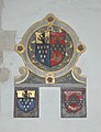 St Leonard and James': family coats of arms (in south aisle?)
 -
 St Leonard and James': marble font installed in 1753
 -
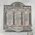 St Leonard and James': monument to Clement, Charles and Humphrey Cottrell-Dormer, died 1914–15


References
- ^ a b c d e f g h i j k l m n o Crossley 1983, pp. 159–168
- ^ "Area selected: West Oxfordshire (Non-Metropolitan District)". Neighbourhood Statistics: Full Dataset View. Office for National Statistics. Archived from the original on 22 June 2011. Retrieved 30 March 2010.
- ^ a b c Sherwood & Pevsner 1974, p. 739.
- ^ a b c Davies, Peter (7 December 2006). "Rousham SS Leonard & James". Dove's Guide for Church Bell Ringers. Retrieved 4 January 2012.
- ^ Dovemaster (25 June 2010). "Bell Founders". Dove's Guide for Church Bell Ringers. Retrieved 5 January 2012.
Sources and further reading
- Crossley, Alan (ed.); Baggs, A.P.; Colvin, Christina; )
- ISSN 0308-5562.
- Sherwood, Jennifer; ISBN 0-14-071045-0.
External links
 Media related to Rousham at Wikimedia Commons
The District of West Oxfordshire | ||
|---|---|---|
| ||
| Towns |  | |
| Large villages | ||
| Other civil parishes (component villages and hamlets) |
| |
| Former districts and boroughs | ||
| Former constituencies | ||