
Rural Municipality of Armstrong
Armstrong | |
|---|---|
CDT) | |
| Website | www |
Armstrong is a rural municipality in the province of Manitoba in Western Canada. It lies in the southern area of the Interlake and was named after James William Armstrong, a Manitoba politician.
History
| Year | Pop. | ±% |
|---|---|---|
| 1981 | 1,957 | — |
| 1986 | 2,039 | +4.2% |
2016 | 1,792 | −2.3% |
| 2021 | 1,967 | +9.8% |
The surrounding area was settled by
The hamlet of Kreuzberg received its first post office in 1910.[3]
The area was originally incorporated as three distinct rural municipalities, Armstrong, Kreuzberg and Chatfield, in 1913.
Incorporating much of the marginal farmland on the western edge of the Rural Municipality of Gimli, this area saw a number of schools built along the railway line that was constructed three years earlier. These were located in the hamlets of Malonton, Meleb, Rembrandt and Kreuzberg.
The hamlet of Kreuzburg was renamed Fraserwood during
During the Great Depression, the rural municipalities of Armstrong, Kreuzberg and Chatfield were dissolved, and were administered as the Local Government District of Armstrong.[4] The region was heavily affected by failure of the wheat crop in this era, resulting in one of the most serious poverty crises in all of Manitoba.[5]
On September 21, 1936
The local government district of Armstrong was subsequently reconstituted as a rural municipality in 1997.
The area is also home to the Narcisse Snake Dens, a provincial wildlife management area which is the world's largest known winter den for garter snakes.
Communities
The rural municipality encompasses and governs the hamlets of Chatfield, Fraserwood, Inwood, Komarno, Malonton, Meleb, Narcisse, Neveton, Rembrandt, Sandridge and Silver.
Demographics
In the 2021 Census of Population conducted by Statistics Canada, Armstrong had a population of 1,967 living in 831 of its 1,056 total private dwellings, a change of 9.8% from its 2016 population of 1,792. With a land area of 1,868.24 km2 (721.33 sq mi), it had a population density of 1.1/km2 (2.7/sq mi) in 2021.[1]
Climate
| Climate data for Fraserwood | |||||||||||||
|---|---|---|---|---|---|---|---|---|---|---|---|---|---|
| Month | Jan | Feb | Mar | Apr | May | Jun | Jul | Aug | Sep | Oct | Nov | Dec | Year |
| Record high °C (°F) | 7.5 (45.5) |
7.5 (45.5) |
15.6 (60.1) |
34 (93) |
37 (99) |
37 (99) |
35 (95) |
38 (100) |
37.5 (99.5) |
26.7 (80.1) |
21.1 (70.0) |
8.9 (48.0) |
38 (100) |
| Mean daily maximum °C (°F) | −13.4 (7.9) |
−9.4 (15.1) |
−1.8 (28.8) |
9.9 (49.8) |
18.8 (65.8) |
22.7 (72.9) |
25.5 (77.9) |
23.9 (75.0) |
17.3 (63.1) |
10 (50) |
−1.5 (29.3) |
−10.6 (12.9) |
7.6 (45.7) |
| Daily mean °C (°F) | −18.7 (−1.7) |
−15 (5) |
−7.3 (18.9) |
3.5 (38.3) |
11.6 (52.9) |
16 (61) |
18.9 (66.0) |
17.4 (63.3) |
11.4 (52.5) |
4.9 (40.8) |
−5.4 (22.3) |
−15.3 (4.5) |
1.8 (35.2) |
| Mean daily minimum °C (°F) | −24 (−11) |
−20.5 (−4.9) |
−12.8 (9.0) |
−2.9 (26.8) |
4.4 (39.9) |
9.3 (48.7) |
12.4 (54.3) |
10.8 (51.4) |
5.4 (41.7) |
−0.2 (31.6) |
−9.3 (15.3) |
−20 (−4) |
−4 (25) |
| Record low °C (°F) | −43.9 (−47.0) |
−42 (−44) |
−38 (−36) |
−28.9 (−20.0) |
−11 (12) |
−2.5 (27.5) |
1.7 (35.1) |
−2 (28) |
−8.3 (17.1) |
−18 (0) |
−38 (−36) |
−40.6 (−41.1) |
−43.9 (−47.0) |
| Average precipitation mm (inches) | 22.9 (0.90) |
18.1 (0.71) |
25.2 (0.99) |
32.5 (1.28) |
51.4 (2.02) |
76.2 (3.00) |
81.8 (3.22) |
70.1 (2.76) |
57.4 (2.26) |
40 (1.6) |
25.4 (1.00) |
25.3 (1.00) |
526.4 (20.72) |
| Source: Environment Canada[6]
| |||||||||||||
Gallery
-
 Fraserwood from the air
 -
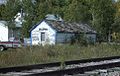 Train station in Silver

Notes
- ^ a b "Population and dwelling counts: Canada, provinces and territories, and census subdivisions (municipalities), Manitoba". Statistics Canada. February 9, 2022. Retrieved February 20, 2022.
- ^
ISBN 0-9690768-3-5.
- Winnipeg Tribune, March 1, 1910.
- ^ Parker, C. E. (Autumn 1965). "The "Disorganized" Municipalities of Manitoba". Manitoba Pageant. 11 (1). Retrieved October 30, 2017.
- Winnipeg Tribune, November 12, 1935.
- ^ Environment Canada - Canadian Climate Normals 1971-2000—Canadian Climate Normals 1971–2000, accessed 19 April 2011
External links
- Official website
- Manitoba Historical Society - Rural Municipality of Armstrong
- Interlake Tourism - Rural Municipality of Armstrong
- Map of Armstrong R.M. at Statcan
Places adjacent to Rural Municipality of Armstrong | ||||||||||||||||
|---|---|---|---|---|---|---|---|---|---|---|---|---|---|---|---|---|
| ||||||||||||||||
Division No. 18, Manitoba (North Interlake Area) | ||||
|---|---|---|---|---|
| Towns |
|  | ||
| Villages |
| |||
| Rural municipalities |
| |||
| First Nations | ||||
| Indian reserves | ||||
| Unorganized areas | ||||
| Unincorporated communities |
| |||
| ||||