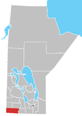
Rural Municipality of Cameron
Appearance
The Rural Municipality of Cameron is a former
Town of Hartney to form the Municipality of Grassland.[2]
The RM was located southwest of Brandon and was home to about 500 people. It was named for John Donald Cameron, the Attorney General of Manitoba at the time.
Communities
Former towns: (previously independently administered)
- Hartney
Unincorporated communities:
Attractions
- Fort Desjarlais
- Fort Ash
- Fort Grand
- Hart-Cam Museum[3]
- Lauder Sandhills
References
- ^ "Manitoba's Municipal History: Rural Municipalities and Local Government Districts". The Manitoba Historical Society. September 21, 2014. Retrieved January 2, 2015.
- ^ "Manitoba's Municipal History: Municipal Amalgamations (2015)". The Manitoba Historical Society. December 1, 2014. Retrieved January 2, 2015.
- ^ Hart-Cam Museum
- Cameron Rural Municipality - Website
- Manitoba Historical Society - Rural Municipality of Cameron
- Map of Cameron R.M. at Statcan
49°26′37″N 100°34′43″W / 49.44361°N 100.57861°W

