
Table Bay
This article needs additional citations for verification. (January 2017) |
| Table Bay | |
|---|---|
| Tafelbaai ( Southern Atlantic Ocean | |
| Basin countries | South Africa |
| Islands | Robben Island |
| Settlements | Cape Town |
Table Bay (

History
Bartolomeu Dias was the first European to explore this region in 1486. The bay, although famous for centuries as a haven for ships, is actually a rather poor natural harbour and is exposed to storm waves from the northwest. Many sailing ships seeking refuge in the bay during the 17th and 18th centuries were driven ashore by winter storms.
The Dutch colonists nevertheless persisted with their efforts on the shores of Table Bay, because good natural harbours along this coastline are almost non-existent. The best of them,
was imprisoned for decades, is in this bay.The bay's beaches were oiled following an accident involving the Dutch tanker Sliedrecht in November 1953. The vessel moved 96 km (60 mi) offshore to pump out 1,000 tonnes of oil that had been fouled with seawater after the initial impact.[1]
Image gallery
-
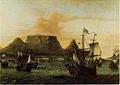 Dutch ships off Table Bay in the 17th century
 -
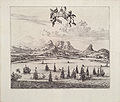 Looking over sailing ships in Table Bay in 1727 with Table Mountain in the background
 -
 Map of Table Bay (1882)
 -
 Map of the Docks and Infrastructure (1884)
 -
 Cape Town from space, looking south over False Bay with Hangklip Point (top left), Cape Point (top right) and Table Bay south and east of the clearly visible, circular Robben Island, February 1995.
 -
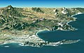 Synthetic perspective with 2× exaggerated elevation, from satellite elevation and image data. Looking east over Cape Peninsula and False Bay (behind) with Robben Island (front left), Table Mountain (centre front) and Cape Point (front right).
 -
 Sketch of Cape Town from the East India Company Ship Defense, en route from the Downs to Bombay, anchored in Table Bay on January 24, 1739.


_p0707_TABLE_BAY.jpg)


See also
References
- ^ "Ship Oil Kills Fish, Penguins". Newcastle Sun (NSW : 1918 - 1954). 1953-11-03. p. 8. Archived from the original on 2021-03-21. Retrieved 2020-04-22.
African seas | |
|---|---|
| Oceans and seas | |
| Gulfs and bays |
|
| Straits | |
| Historical seas | |