
Sankt Peter, Baden-Württemberg
You can help expand this article with text translated from the corresponding article in German. (February 2009) Click [show] for important translation instructions.
|
St. Peter | |
|---|---|
Abbey of St. Peter in the Black Forest | |
 Coat of arms | |
Location of St. Peter within Breisgau-Hochschwarzwald district 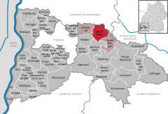 | |
Breisgau-Hochschwarzwald | |
| Government | |
| • Mayor (2016–24) | Rudolf Schuler[1] (Ind.) |
| Area | |
| • Total | 35.93 km2 (13.87 sq mi) |
| Elevation | 716 m (2,349 ft) |
| Population (2022-12-31)[2] | |
| • Total | 2,721 |
| • Density | 76/km2 (200/sq mi) |
| Time zone | UTC+01:00 (CET) |
| • Summer (DST) | UTC+02:00 (CEST) |
| Postal codes | 79271 |
| Dialling codes | 07660 |
| Vehicle registration | FR |
| Website | www.st-peter-schwarzwald.de |
Sankt Peter is a municipality in the district of Breisgau-Hochschwarzwald in Baden-Württemberg in Germany.
Geography
Location
St. Peter is a
Administrative structure
To the municipality of St. Peter belong the
History
The
When the estates of the Church were seized and sold or transferred during Napoleon's conquest of Europe, the village of St. Peter was handed to the Grand Duchy of Baden in 1806 and, since 1952, they have been part of the state of Baden-Württemberg.
In 1899, fire broke out in the village centre of St. Peter,[3] whereupon 23 houses were destroyed and 150 people made homeless.[4]
At the end of the
| Population growth | ||||||||||||||
|---|---|---|---|---|---|---|---|---|---|---|---|---|---|---|
| Year | 1806 | 1871 | 1900 | 1925 | 1939 | 1950 | 1961 | 1970 | 1989 | 1995 | 2005 | 2010 | 2015 | |
| Population | 1480 | 1308 | 1383 | 1378 | 1426 | 1500 | 1529 | 1797 | 2207 | 2362 | 2508 | 2547 | 2583 | |
Source: Statistisches Landesamt Baden-Württemberg (except 1806); 1871–1970: Census results
Gallery
-
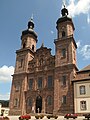 The abbey church of St. Peter and St. Paul
 -
 Gateway to the abbey courtyard (Klosterhof)
 -
 Steyrer Strasse
 -
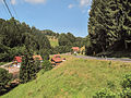 Panorama between Sankt Peter and the Glottertal valley


References
- ^ Aktuelle Wahlergebnisse, Staatsanzeiger, accessed 11 September 2021.
- Statistisches Landesamt Baden-Württemberg. June 2023.
- ISBN 3-7995-7041-1, p. 371
- ^ Chronicle of the Municipality of St. Peter
- ^ Arbeitsgemeinschaft Ebringer Dorfgeschichte (publ.): Ebringer Dorfgeschichte Nr. 2. Ebringen unterm Hakenkreuz. Zeitzeugenberichte, Ebringen 2008, pp. 33 and 38
External links
- (in German) St. Peter: History and images
- (in German) St. Peter

| International | |
|---|---|
| National | |
| Geographic | |
This Breisgau-Hochschwarzwald location article is a stub. You can help Wikipedia by expanding it. |