
Selworthy
| Selworthy | |
|---|---|
Avon and Somerset | |
| Fire | Devon and Somerset |
| Ambulance | South Western |
| UK Parliament | |
Selworthy is a small village and
At 308 metres (1,010 ft)
Bossington is separated from
History
The name of the village means "enclosure or settlement near sallows or willows". In the
Selworthy was part of the
Selworthy was rebuilt as a
Few of the buildings preceding 1828 survive, but those that do include the church, the
Governance
Selworthy shares a
Until the recent (2023) formation of the unitary Somerset Council, the village was within the non-metropolitan district of Somerset West and Taunton, which was established on 1 April 2019. Before that, it was previously in the district of West Somerset, which was formed on 1 April 1974 under the Local Government Act 1972, and part of Williton Rural District before that.[17]
Somerset Council is responsible for
As Selworthy falls within the
It is also part of the
Church

On the hill above the village is the whitewashed 15th-century Church of All Saints, with a 14th-century tower. The pulpit includes a 17th-century hourglass and the iron-bound parish chest dates from the same time.[20] Within the church is a copy of the Chained Book of 1609 by Bishop John Jewel, entitled Defense of the Apologie of the Church of England.[21]
It has been designated as a Grade I listed building.[22]
In the churchyard is a medieval cross with three octagonal steps, a square socket, and an octagonal shaft. The head is missing.
The liturgical scholar and church historian Francis Carolus Eeles OBE is buried in the churchyard.[24]
The
The
Demography
The population of the parish of Selworthy is 477;[1] this has grown by 100 since 1801 when the population was 418.[27] It has a predominantly ageing population with 80% being over 45 years old.[28]
Gallery
-
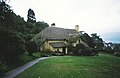 Tea room
 -
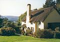 Thatched cottage


References
- ^ a b "Statistics for Wards, LSOAs and Parishes — SUMMARY Profiles" (Excel). Somerset Intelligence. Retrieved 4 January 2014.
- ^ ISBN 0-946159-94-7.
- ^ ISBN 0-7028-8380-8.
- ^ Lincoln Archer (28 April 2005). "Letting nature take its course". BBC News. Retrieved 18 February 2021.
- ^ "Shifting shores in the South West" (PDF). National Trust. Archived from the original (PDF) on 6 December 2008. Retrieved 13 October 2008.
- ^ "Selworthy Parish". Exmoor National Park. Archived from the original on 16 July 2011. Retrieved 26 January 2008.
- ^ Savage, James (1830). History of the Hundred of Carhampton: In the County of Somerset. Longman, Rees, Orme, Brown, & Green. pp. 182–196.
- ^ ISBN 0-85115-671-1.
- ^ "Carhampton Hundred". Domesday Map. Archived from the original on 8 October 2012. Retrieved 23 September 2011.
- ^ "Selworthy". Tour UK. Archived from the original on 13 January 2008. Retrieved 26 January 2008.
- ^ Historic England. "Periwinkle Cottage Tea Rooms (1058026)". National Heritage List for England. Retrieved 26 January 2008.
- ^ Historic England. "No 1 Lower Cottage and Greenbanks (1057988)". National Heritage List for England. Retrieved 26 January 2008.
- ^ Historic England. "Cottage (National Trust Estate No 68) (1058025)". National Heritage List for England. Retrieved 26 January 2008.
- ^ Historic England. "Selworthy Cottage and wall abutting on south front returned to road (1345423)". National Heritage List for England. Retrieved 26 January 2008.
- ^ Historic England. "The Tithe Barn and Tithe Barn Cottage (1057990)". National Heritage List for England. Retrieved 26 January 2008.
- ^ "Selworthy and Minehead Without Parish Council - West Somerset Council". westsomersetonline.gov.uk. Retrieved 4 November 2017.
- ^ "Williton RD". A vision of Britain Through Time. University of Portsmouth. Retrieved 5 January 2014.
- ^ "The Authority". Exmoor National Park. Archived from the original on 24 December 2007. Retrieved 29 November 2007.
- ^ "Exmoor National Park NMP". English Heritage. Retrieved 29 November 2007.
- ^ "Selworthy". Pictures of England. Retrieved 26 January 2008.
- ^ "Selworthy". Everything Exmoor. Retrieved 26 January 2008.
- ^ Historic England. "Church of All Saints (1296005)". National Heritage List for England. Retrieved 26 January 2008.
- ^ Historic England. "Remains of churchyard cross (1058028)". National Heritage List for England. Retrieved 26 January 2008.
- ^ "Francis Carolus Eeles grave monument in All Saints , Selworthy, Somerset, England". Gravestone Photographic Resource. Retrieved 2 May 2017.
- ^ Historic England. "Chapel of St Leonard (1345394)". National Heritage List for England. Retrieved 28 August 2017.
- ^ Historic England. "Lynch Chapel of Ease (1057997)". National Heritage List for England. Retrieved 5 November 2017.
- ^ "Selworthy AP/CP: Total Population". A vision of Britain through time. Retrieved 26 January 2008.
- ^ "Selworthy Parish housing report" (PDF). Exmoor National Park. Archived from the original (PDF) on 16 July 2011. Retrieved 26 January 2008.
Further reading
- Haw, Graham (2001). The Book of Luccombe & Selworthy.
- Reminiscences of an Old West Country Clergyman by W H Thornton (edited by Duff Hart-Davis), Ludlow 2010. Thornton lived at Selworthy in the 1840s.
External links

| International | |
|---|---|
| National | |