
Sheepwash Channel Railway Bridge
Sheepwash Channel Railway Bridge | |
|---|---|
Cherwell Valley Line | |
| Crosses | Sheepwash Channel |
| Locale | Oxford, England |
| Maintained by | Network Rail |
| Characteristics | |
| Design | Girder bridge |
| Material | Steel |
| No. of spans | 1 |
| Location | |
 | |
Sheepwash Channel Railway Bridge is a
Osney Island and the Botley Road
.
Railways around Oxford | ||||||||||||||||||||||||||||||||||||||||||||||||||||||||||||||||||||||||||||||||||||||||||||||||||||||||||||||||||||||||||||||||||||||||||||||||||||||||||||||||||||||||||||||||||||||||||||||||||||||||||||||||||
|---|---|---|---|---|---|---|---|---|---|---|---|---|---|---|---|---|---|---|---|---|---|---|---|---|---|---|---|---|---|---|---|---|---|---|---|---|---|---|---|---|---|---|---|---|---|---|---|---|---|---|---|---|---|---|---|---|---|---|---|---|---|---|---|---|---|---|---|---|---|---|---|---|---|---|---|---|---|---|---|---|---|---|---|---|---|---|---|---|---|---|---|---|---|---|---|---|---|---|---|---|---|---|---|---|---|---|---|---|---|---|---|---|---|---|---|---|---|---|---|---|---|---|---|---|---|---|---|---|---|---|---|---|---|---|---|---|---|---|---|---|---|---|---|---|---|---|---|---|---|---|---|---|---|---|---|---|---|---|---|---|---|---|---|---|---|---|---|---|---|---|---|---|---|---|---|---|---|---|---|---|---|---|---|---|---|---|---|---|---|---|---|---|---|---|---|---|---|---|---|---|---|---|---|---|---|---|---|---|---|---|
| ||||||||||||||||||||||||||||||||||||||||||||||||||||||||||||||||||||||||||||||||||||||||||||||||||||||||||||||||||||||||||||||||||||||||||||||||||||||||||||||||||||||||||||||||||||||||||||||||||||||||||||||||||
The bridge is close to Rewley Road Swing Bridge just to the east,[2] an older and now disused swing bridge for the former Buckinghamshire Railway line of London and North Western Railway that used to serve the Oxford Rewley Road railway station.[3] It is also close to Rewley Road Bridge to the east.[1] Sheepwash channel links the River Thames with the Oxford Canal via Castle Mill Stream and Isis Lock.
Gallery
-
 View of the Sheepwash Channel Railway Bridge in the background and the site of the old Rewley Road Swing Bridge in the foreground
 -
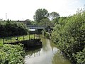
 The Sheepwash Channel with the new railway bridge and the old railway swing bridge
 -
 Looking north along the railway line from Oxford railway station over Sheepwash Channel Railway Bridge towards Cripley Meadow


References
- ^ a b "Sheepwash Channel Railway Bridge". UK: CanalPlanAC. Retrieved 19 September 2012.
- ISBN 978-0-9522671-7-1.
- ^ "Sheepwash Channel — Oxford Canal / River Thames". UK: Movable Bridges in the British Isles. Retrieved 15 September 2012.
This article about an Oxfordshire building or structure is a stub. You can help Wikipedia by expanding it. |
This article about a bridge in the United Kingdom is a stub. You can help Wikipedia by expanding it. |