
Sichuan Basin
| Sichuan Basin | |
|---|---|
| Red Basin | |
Southwest China | |
| Coordinates | 30°30′N 105°30′E / 30.500°N 105.500°E |
The Sichuan Basin (
Geography

The Sichuan Basin is an expansive 229,500 km2 (88,600 sq mi) lowland region in China that is surrounded by upland regions and mountains.
The westernmost section of the Sichuan Basin is the Chengdu Plain, occupied by Chengdu, provincial capital of Sichuan. The Chengdu Plain is largely alluvial, formed by the Min River and other rivers fanning out when entering the basin from the northwest. This flat region is separated from the rest of the basin by the Longquan Mountains. The central portions of the Sichuan Basin are generally rolling, covered by low hills, eroded remnants of the uplifted Sichuan Basin floor. In some parts of the extreme northern Basin and in Weiyuan County in the southwest, there are ancient dome-shaped low mountains in their own right.[2] The Jialing River enters from the north and flows across the entire width of the Sichuan Basin to meet the Yangtze at Chongqing. Northeast of Chongqing, the Yangtze cuts an outlet through the mountains at the eastern edge of the basin known as the Three Gorges. Other significant rivers almost wholly within the Sichuan Basin include the Tuo River, the Fu River, and the Qu River.[3]
Climate
Due to the surrounding mountains, the Sichuan Basin often experiences
A moist, often overcast, four-season climate dominates the basin, with cool to mild
Geology
The Sichuan Basin forms the rigid northwest edge of the
Until 6 million years ago, a large lake filled the Sichuan Basin.[4] The basin's soils today are largely exposed red sandstone,[1] leading to the "Red Basin" nickname for the region. The Sichuan Basin's well preserved Jurassic layers have proven valuable to paleontology, such of those of the Shaximiao Formation, near Zigong, which preserves abundant remains of dinosaurs and other prehistoric animals.[7]
Biodiversity
.jpg)
Originally, the Sichuan Basin was covered by the Sichuan Basin evergreen broadleaf forests. With human settlement, agriculture has taken root across most of the fertile basin and reduced the original forest to small patches on hills and mountains including
Previously only known in fossils and thought to be extinct, the
Human development
History

Relative to the areas surrounding the upper
During the period of the
Demographics and economy
Owing to its vast fertile plains, the Sichuan Basin has long supported a high concentration of human population.

While population growth stagnated during the Great Leap Forward, it has since recovered. Today, the basin has a population of approximately 100 million.
Culture
Some unique elements of Sichuanese culture remain in the Basin.
Transportation
While transportation across the Sichuan Basin has been facilitated by relative flatness, access to and from the basin has long been a challenge.
Transportation to the west from Sichuan has proven to be an even greater challenge, with steep mountains and deep valleys hindering movement. Nevertheless, the Sichuan Basin has played a role as a stopover on the
In the 20th century, the Sichuan Basin was connected to the rest of China by railways. The
Highway construction within Sichuan Basin intensified in the 21st century.
Maps gallery
-
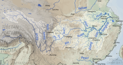 Map of the Yangtze River drainage basin with the Sichuan Basin in the centre
 -
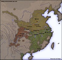 Map showing the second Shu State in the Sichuan Basin during theThree Kingdoms period
 -
 Sichuanese dialects are spoken in the Sichuan Basin and surrounding areas
 -
 The 4th century BC Shu Roads connected Sichuan Basin with the Yellow River valley (Shaanxi)
 -
 Sichuan Basin in relation to Southeast Asia and the eastern part of South Asia, with the Tea Horse Road routes highlighted in red


See also
References
- ^ a b c d "Sichuan Basin". Encyclopædia Britannica. Retrieved 11 April 2017.
- ISBN 9787503141782.
- ^ ISBN 978-0028971841.
- .
- ^ "Sichuan Basin". GES DISC. NASA. Archived from the original on 12 April 2017. Retrieved 11 April 2017.
- ^ Li, K; Liu, J.; Yang, C.; Hu, F. (2011). "Dinosaur assemblages from the Middle Jurassic Shaximiao Formation and Chuanjie Formation in the Sichuan-Yunnan Basin, China". Volumina Jurassica. 9 (9): 21–42.
- ^ "Sichuan Basin evergreen broadleaf forests". Terrestrial Ecoregions. World Wildlife Fund.
- ^ "Qionglai-Minshan conifer forests". Terrestrial Ecoregions. World Wildlife Fund.
- ^ "Daba Mountains evergreen forests". Terrestrial Ecoregions. World Wildlife Fund.
- JSTOR 3647458.
- ^ ISBN 9780007221783.
- ^ ISBN 9780521124331.
- ISBN 978-0804754965.
- OCLC 9806746.
- ^ ISBN 9781741041859.
- ^ Energy Citations Database (ECD) - - Document #7024946}}
- ISBN 9787547109151.
- ^ Johnston, Brian (2006). Boxing with Shadows: Travels in China. Melbourne University Publishing. p. 140.
- ISBN 9780595425518.
- ISBN 978-0226732442.
- ^ "新中国档案:成渝铁路--新中国的第一条铁路". CCTV. Xinhua News Agency. 11 August 2009. Retrieved 6 October 2017.
- ^ (Chinese) "第八期 宝成铁路" 中国制造之科技" Accessed 2017-10-06
- ^ Qiao, Han; Xi, Fan (16 August 2017). "Chinese high-speed rail expansion on the fast track". International Railway Journal. Retrieved 6 October 2017.
- ^ "China to build Xi'an-Chengdu high-speed railway". China Daily. Xinhua. 16 January 2010. Retrieved 6 October 2017.
- ISBN 9787114060656.