
Solomons, Maryland
Solomons, Maryland | ||
|---|---|---|
FIPS code 24-73325 | | |
| GNIS feature ID | 1676619 | |
.jpg)
Solomons, also known as Solomons Island, is an unincorporated community and
Geography
Solomons is located at the southern tip of Calvert County at 38°20′11″N 76°27′51″W / 38.33639°N 76.46417°W (38.336431, −76.464102).[3] It includes Solomons Island and mainland on the north side of the mouth of Patuxent River, where it meets the Chesapeake Bay. It is just across from the U.S. Naval Air Station Patuxent River (on the south side of the mouth of the Patuxent River). The city also included the west and south part of the Dowell Peninsula.
According to the United States Census Bureau, the Solomons CDP has a total area of 2.3 square miles (6.0 km2), of which 2.0 square miles (5.2 km2) is land and 0.35 square miles (0.9 km2), or 14.76%, is water,[2] consisting mainly of Back Creek, a tidal inlet that extends north from the Patuxent River.
Climate
The climate in this area is characterized by hot, humid summers and generally mild to cool winters. According to the
| Climate data for Solomons, Maryland (1991–2020 normals, extremes 1893–present) | |||||||||||||
|---|---|---|---|---|---|---|---|---|---|---|---|---|---|
| Month | Jan | Feb | Mar | Apr | May | Jun | Jul | Aug | Sep | Oct | Nov | Dec | Year |
| Record high °F (°C) | 76 (24) |
79 (26) |
89 (32) |
91 (33) |
100 (38) |
99 (37) |
103 (39) |
104 (40) |
99 (37) |
95 (35) |
82 (28) |
75 (24) |
104 (40) |
| Mean daily maximum °F (°C) | 45.3 (7.4) |
47.6 (8.7) |
54.9 (12.7) |
65.4 (18.6) |
74.2 (23.4) |
83.8 (28.8) |
87.9 (31.1) |
86.3 (30.2) |
79.9 (26.6) |
68.7 (20.4) |
58.6 (14.8) |
50.1 (10.1) |
66.9 (19.4) |
| Daily mean °F (°C) | 37.7 (3.2) |
39.2 (4.0) |
46.3 (7.9) |
56.4 (13.6) |
66.0 (18.9) |
75.7 (24.3) |
80.3 (26.8) |
78.7 (25.9) |
72.4 (22.4) |
61.0 (16.1) |
50.8 (10.4) |
42.3 (5.7) |
58.9 (14.9) |
| Mean daily minimum °F (°C) | 30.1 (−1.1) |
30.8 (−0.7) |
37.6 (3.1) |
47.4 (8.6) |
57.9 (14.4) |
67.6 (19.8) |
72.7 (22.6) |
71.0 (21.7) |
65.0 (18.3) |
53.4 (11.9) |
43.0 (6.1) |
34.5 (1.4) |
50.9 (10.5) |
| Record low °F (°C) | −3 (−19) |
−5 (−21) |
10 (−12) |
17 (−8) |
32 (0) |
47 (8) |
53 (12) |
49 (9) |
43 (6) |
30 (−1) |
13 (−11) |
−1 (−18) |
−5 (−21) |
| Source: | |||||||||||||
History
Early settlers
Originally called Bourne's Island (1680), then Somervell's Island (1740), Solomons takes its name from 19th century Baltimore businessman Isaac Solomon, who established a cannery there shortly after the Civil War. Solomon's home still stands on the front of the island.
The area has been inhabited since colonial times.[7]
Shipbuilding and maritime activity
In the 19th century, shipyards developed to support the island's fishing fleet. The Marsh Shipyard built
During World War II, the island was chosen by the Allied command as the site for
Coincidentally, many of the servicemen who trained at the Solomons base in Maryland were sent to fight in the Solomon Islands in the Pacific Ocean.
Solomons was the site of the following U.S. Navy activities during the war:[8]
- Naval Mine Warfare Test Station, now the Solomons Annex Naval Recreation Center
- Naval Amphibious Training Base, now Calvert Marine and Harbours Point Park
- Mine Warfare Experimental Station
- Naval Dispensary, at Naval Amphibious Training Base
Governor Thomas Johnson Bridge
Solomons was a rather isolated boat-building town housing the
Tourism
The town now welcomes tourists with numerous marinas, seafood restaurants, gift shops, a boardwalk, a sculpture garden, the
The Annmarie Sculpture Garden & Arts Center in Solomons is a
Demographics
| Census | Pop. | Note | %± |
|---|---|---|---|
| 2020 | 2,650 | — | |
| U.S. Decennial Census[16] | |||
As of the census
In 2000, 6.7% of Solomons residents identified as being of
There were 689 households, out of which 15.4% had children under the age of 18 living with them, 47.8% were married couples living together, 4.8% had a female householder with no husband present, and 45.1% were non-families. 39.0% of all households were made up of individuals, and 24.8% had someone living alone who was 65 years of age or older. The average household size was 1.97 and the average family size was 2.56.
In the CDP, the population was spread out, with 13.1% under the age of 18, 3.1% from 18 to 24, 21.0% from 25 to 44, 21.2% from 45 to 64, and 41.7% who were 65 years of age or older. The median age was 56 years. For every 100 females, there were 80.1 males. For every 100 females age 18 and over, there were 76.8 males.
The median income for a household in the CDP was $48,532, and the median income for a family was $74,318. Males had a median income of $64,833 versus $34,313 for females. The per capita income for the CDP was $33,049. About 2.1% of families and 3.4% of the population were below the poverty line, including 7.0% of those under age 18 and none of those age 65 or over.
Gallery
-
 Our Lady Star of the Sea Catholic Church, December 2008
 -
 Solomons United Methodist Church, December 2008
 -
 Governor Thomas Johnson Bridge, December 2008
 -
 A peaceful pierside scene of calm water, February 2010
 -
 A visitors' wayfinding compass-marker on Solomons Island picturing a bugeye boat
 -
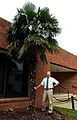 Mature palm tree in front of the Chesapeake Biological Laboratory


References
- ^ "2020 U.S. Gazetteer Files". United States Census Bureau. Retrieved April 26, 2022.
- ^ a b "Geographic Identifiers: 2010 Demographic Profile Data (G001): Solomons CDP, Maryland". U.S. Census Bureau, American Factfinder. Archived from the original on February 12, 2020. Retrieved August 22, 2014.
- ^ "US Gazetteer files: 2010, 2000, and 1990". United States Census Bureau. February 12, 2011. Retrieved April 23, 2011.
- ^ Climate Summary for Solomons, Maryland
- ^ "NowData – NOAA Online Weather Data". National Oceanic and Atmospheric Administration. Retrieved July 5, 2021.
- ^ "Station: Solomons, VA". U.S. Climate Normals 2020: U.S. Monthly Climate Normals (1991-2020). National Oceanic and Atmospheric Administration. Retrieved July 5, 2021.
- ^ Mountford, Kent (November 2001). "Cove Point: Mariners's safe harbor now threatened by ships". Chesapeake Bay Journal. Retrieved May 12, 2008.
- ^ Clancey, Patrick. "U.S. Naval Activities, World War II, By State [Maryland]". HyperWar Foundation. Retrieved April 17, 2008.
- ^ "Smithsonian Affiliations". Affiliations.si.edu. Retrieved October 17, 2011.
- ^ [1] Archived August 27, 2010, at the Wayback Machine
- ^ [2] Archived August 27, 2010, at the Wayback Machine
- ^ Ignacio Villarreal (May 21, 2008). "Picasso Going to Annmarie Garden Sculpture Park & Arts Center in Southern Maryland". Artdaily.org. Retrieved October 17, 2011.
- ^ [3] Archived March 7, 2012, at the Wayback Machine
- ^ [4] Archived October 11, 2008, at the Wayback Machine
- ^ [5] Archived September 19, 2010, at the Wayback Machine
- ^ "Census of Population and Housing". Census.gov. Retrieved June 4, 2016.
- ^ "U.S. Census website". United States Census Bureau. Retrieved January 31, 2008.
- ^ "Ancestry Map of Welsh Communities". Epodunk.com. Archived from the original on July 13, 2015. Retrieved April 16, 2015.
Bibliography
- Cole, Merle T. (2007). "The First Aerial Photograph of Solomons?". Warship International. XLIV (4): 315–318. ISSN 0043-0374.
External links
 Media related to Solomons, Maryland at Wikimedia Commons
 Solomons travel guide from Wikivoyage
Municipalities and communities of Calvert County, Maryland, United States | ||
|---|---|---|
| Towns |  | |
| CDPs | ||
| Other communities | ||
| Ghost town | ||
| ||
| International | |
|---|---|
| National | |