
Mallaig: Difference between revisions
Rescuing 1 sources and tagging 0 as dead. #IABot (v1.6.2) |
|||
| Line 95: | Line 95: | ||
* [http://www.paperclip.org.uk/travel/Mallaig.htm Photos of Mallaig] |
* [http://www.paperclip.org.uk/travel/Mallaig.htm Photos of Mallaig] |
||
* [http://westword.org.uk/ West Word - Community Newspaper] |
* [http://westword.org.uk/ West Word - Community Newspaper] |
||
* [http://www.scotlandthemovie.com/ |
* [https://web.archive.org/web/20100311024842/http://www.scotlandthemovie.com/movIes/fwaves.html Breaking the Waves filming locations] |
||
* [http://www.scotlandthemovie.com/movies/flocalhero.html Local Hero filming locations] |
* [http://www.scotlandthemovie.com/movies/flocalhero.html Local Hero filming locations] |
||
* [http://www.railbrit.co.uk/Mallaig_Extension_Railway/frame.htm West Highland Railway Mallaig Extension] |
* [http://www.railbrit.co.uk/Mallaig_Extension_Railway/frame.htm West Highland Railway Mallaig Extension] |
||
Revision as of 07:30, 14 January 2018
Mallaig
| |
|---|---|
 Approaching Mallaig harbour on the ferry from the Isle of Skye. | |
 Mallaig Location within the Lochaber area | |
| Population | 797 (2001 Census)[1] |
| OS grid reference | NM 67693 96810 |
| Council area | |
| Lieutenancy area | |
| Country | Scotland |
| Sovereign state | United Kingdom |
| Post town | MALLAIG |
| Postcode district | PH41 |
| Dialling code | 01687 |
| UK Parliament | |
| Scottish Parliament | |
Mallaig
The village of Mallaig was founded in the 1840s, when Lord Lovat, owner of North Morar Estate, divided up the farm of Mallaigvaig into seventeen parcels of land and encouraged his tenants to move to the western part of the peninsula and turn to fishing as a way of life.[3] The population and local economy expanded rapidly in the 20th century with the arrival of the railway.[3] Ferries operated by Caledonian MacBrayne and Bruce Watt Sea Cruises sail from the port to Armadale on the Isle of Skye, Inverie in Knoydart, and the isles of Rùm, Eigg, Muck, and Canna. Mallaig is the main commercial fishing port on the West Coast of Scotland, and during the 1960s was the busiest herring port in Europe.[3] Mallaig prided itself at that time on its famous traditionally smoked kippers, but today only one traditional smokehouse remains, Jaffy's and Sons. Mallaig and the surrounding area is a popular area for holidays.
The majority of the community speaks English, with a minority of residents speaking both English and Gaelic. In addition, traditional Gaelic is still taught in the school[
Education
Mallaig has extensive
Mallaig has its own primary school, which recently accepted the
Mallaig also has its own High School, opened in 1989 (however a secondary school had previously existed in a slightly different location) which caters for Mallaig, the villages of Morar and Arisaig, along with the nearby Small Isles of Eigg, Rùm, Muck and Canna and finally the nearby Knoydart peninsula. The school has increasing numbers of pupils from the Small Isles, and as daily travel from home to school is impossible, these pupils are boarded in the school's hostel.[1]
Local services
Mallaig has several restaurants, cafes, and takeaways along with a community-run swimming pool and leisure centre. The main focus is on the tourist trade during the summer, however some facilities are open all year round, including the swimming pool. Mallaig has three hotels, lots of self-catering accommodation and several guest houses.
There are two banks and three pubs. The compact village centre is close to the harbour and railway station, with residential areas beyond to the south and east of the harbour. Most of the retail premises are in the main street, or on Davies Brae, which runs south from the village centre. The swimming pool is at the high point of the village on Fank Brae.
There are two minimarkets, and gift shops. An art gallery sells work by local artists. There is a small bookshop A heritage centre next to the railway station is based around old photographs of the locality, but as Mallaig has only existed during the age of photography this offers a good introduction to the history and heritage of the locality. There are
Transport
The West Highland Line links Mallaig railway station by rail to Fort William, Oban and Glasgow.[5] The line was voted the top rail journey in the world by readers of independent travel magazine Wanderlust in 2009, ahead of the iconic Trans-Siberian and the Cuzco to Machu Picchu line in Peru.[citation needed] The five-hour trip to Glasgow Queen Street railway station passes through spectacular scenery including seascapes, lochsides, mountain and moorland terrain, and offers views of Loch Lomond, the Gare Loch, Rannoch Moor, Ben Nevis, Glenfinnan and Glen Shiel, and Loch Eil. The line also runs along the Clyde between Helensburgh and Glasgow and offers views across the estuary.
In the summer the
Sheil Buses operate a bus service from Mallaig to Fort William. Buses also run south along the A861 to the villages of Acharacle and Strontian.
Mallaig is an important ferry port with regular Caledonian MacBrayne ferry services to Armadale on the Isle of Skye, a thirty-minute sailing. They also run a daily service to the Small Isles of Canna, Rùm, Eigg and Muck, although the timetable and itinerary differ from day to day. Calmac also offers a non-landing ticket which allows visitors to cruise the Small Isles.
In addition, a local ferry service owned by former lifeboatman Bruce Watt sails daily to

Mallaig as a filming location
The Mallaig railway was used during the filming of the
The 1996 film Breaking the Waves was largely filmed in Mallaig and the surrounding area, and the beach scenes of Local Hero were filmed at Morar and Arisaig, a few miles to the south.
Gallery
-
 Approaching Mallaig harbour on the ferry from Skye
 -
 Mallaig harbour from the ferry to the Isle of Skye
 -
 Mallaig viewed from the Ferry Road to the north of the village
 -
 The Mallaig to Armadale car ferry
 -
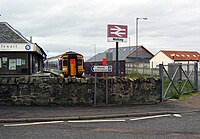 Mallaig railway station
 -
 Mallaig harbour

.jpg)


References
- ^ "Comparative Population Profile: Mallaig Locality, Scotland". Scotland's Census Results OnLine. Archived from the original on 22 March 2012. Retrieved 7 March 2011.
{{cite web}}: Unknown parameter|dead-url=ignored (|url-status=suggested) (help) - ^ "Mallaig circuit". walkhighlands. walkhighlands. Retrieved 9 March 2011.
- ^ a b c Anon. "Mallaig and its story". Mallaig Heritage Centre. Archived from the original on 4 March 2004. Retrieved 14 September 2009.
{{cite web}}: Unknown parameter|dead-url=ignored (|url-status=suggested) (help) - ^ Anon (2007). "The Royal Commission of Inquiry into the Condition of Crofters and Cottars in the Highlands and Islands". Lochaber College e-library. Lochaber College. Retrieved 14 September 2009.
- ^ "Glasgow to Mallaig: Great Train Journeys". Daily Telegraph. 4 March 2013.
External links
- Map sources for Mallaig
- Photos of Mallaig
- West Word - Community Newspaper
- Breaking the Waves filming locations
- Local Hero filming locations
- West Highland Railway Mallaig Extension
- Mallaig High School[permanent dead link]
- Mallaig Pool & Leisure
| International | |
|---|---|
| National | |