
Meall an t-Suidhe
| Meall an t-Suidhe | |
|---|---|
Scottish gaelic | |
| Geography | |
 Meall an t-Suidhe | |
| Parent range | Grampian Mountains |
| OS grid | NN 13943 72985 |
| Climbing | |
| Easiest route | Hike from Glen Nevis |
The Meall an t-Suidhe[1] is a mountain in Scotland, located close to the Ben Nevis.
Etymology
Meall an t-Suidhe is a
Features

Usually considered as the wesetern shoulder of the
Geology

The area of the Meall an t-Suidhe is crossed by a line taking apart two portions of the Ben Nevis granites; the innermost of the two portions is considered by geologists younger than the external one. These outer granites are often interrupted by porphyritic dykes.[6]
Access to the summit

The mountain is located close to the pony trail, the most frequented route to the Ben Nevis.[3] Some guidebooks propose the ascent to its summit as an easier and less demanding alternative to the Ben Nevis. They also note that Meall an t-Suidhe is peaceful and is more often free from clouds than its more imposing and crowded neighbour. Getting to the top can roughly take less than 6 hours' walking (there and back) from the Glen Nevis visitor centre. The hike with good weather is not difficult but in its last part involves walking out of waymarked footpaths.[7]
Environment and landscape conservation
The mountain is included into the Ben Nevis and Glen Coe National Scenic Area, one of the National scenic areas established in order to protect Scottish finest scenery and to ensure its protection from inappropriate development.[8]
References
- ^ DoBIH(Database of British and Irish Hills). Retrieved 12 June 2022.
- ISBN 9780002111355. Retrieved 14 June 2022.
- ^ ISBN 9781496216977. Retrieved 14 June 2022.
- The Midland Naturalist. 6. D. Bogue. Retrieved 12 June 2022.
- ^ Ordnance Survey. "Grid Reference: NN1393972994". Geograph® Britain and Ireland. Retrieved 13 June 2022.
- ^ "Daily program of excursions n.8 - Ben Nevis". Guide to Excursion, A. 1-19, B, C. 1-18. Vol. 2. International Geological Congress. 1948. p. 18. Retrieved 13 June 2022.
- ISBN 9781783624270. Retrieved 14 June 2022.
- ^ "National Scenic Areas". NatureScot. Retrieved 12 June 2022.
Panorama
![]() Media related to Meall an t-Suidhe at Wikimedia Commons
Media related to Meall an t-Suidhe at Wikimedia Commons
-
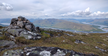 Westward panorama with Loch Linnhe and Loch Eil
 -
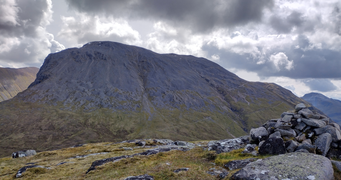 Eastward panorama with the Ben Nevis
 -
 Meall an t-Suidhe, mountain and lake, as seen from the Ben Nevis footpath


