
Stalbridge
| Stalbridge | |
|---|---|
Dorset | |
| Ceremonial county | |
| Region | |
| Country | England |
| Sovereign state | United Kingdom |
| Post town | Sturminster Newton |
| Postcode district | DT10 |
| Dialling code | 01963 |
| Police | Dorset |
| Fire | Dorset and Wiltshire |
| Ambulance | South Western |
North Dorset | |
| Website | Stalbridge Council |
Stalbridge (
Though relatively small, Stalbridge has its own independent supermarket, dispensing pharmacy, dentist and optician, as well as many other services, reflecting its
History

There was a settlement near Stalbridge in
Stalbridge was home to scientist Robert Boyle (see below), and writer Douglas Adams, who wrote much of The Hitchhiker's Guide to the Galaxy in the town.[6] The town also boasts that it is home to the oldest living male twins in the world.
Artist Sir James Thornhill lived just south of the town, in Thornhill Park, which he bought in 1725. The house is believed to have been originally owned by Sir Walter Raleigh in the 16th century.[citation needed] In 1727, Sir James Thornhill erected an obelisk in the park to honour the accession of King George II.[5]
From September 1863 Stalbridge was served by
Stalbridge House
In 1618 Mervyn Tuchet (or Audley), 2nd Earl of Castlehaven, who had inherited Stalbridge Park from his father, decided to build a mansion house on his Stalbridge estate. He enclosed an area used as common land to the northwest of the church, moving tenant farmers out, and built a Jacobean style mansion, the fifth largest house in Dorset.
In 1631 the earl's eldest son
James sold the house to
At some point during the house's history a 2-metre-high (6 ft 7 in) stone wall was built around the boundary of Stalbridge Park. There is some argument as to when and why the wall was built. It may have been commissioned by Castlehaven as a status symbol, work for
By 1822 the house was in poor repair and the current owner, the Marquess of Anglesey, had it demolished.[8] By 1827 all that remained was the raised area where it had stood. The stone was sold off and much of it is in use elsewhere in the town, including the large farm house which now stands in the park.
There are many popular local myths and ghost stories about the demise of the house, mostly involving a fire destroying the house.
Stalbridge Park features in Thomas Hardy's Wessex as "Stapleford Park".[8]
Governance
After
Stalbridge was the major part of Blackmore
Demographics
The town of Stalbridge had a population of 2,396 as of the 2011 census.
Geography


Stalbridge lies in the Blackmore Vale. As an area of hills, this means that the town lies largely on a gradient. The high street through the town centre follows the contour of the landscape, before climbing up Church Hill past the parish church of St. Mary, heading towards the Somerset border and Henstridge. To the east of the high street, Station Road heads down the hill, heading towards the Stalbridge trading estates, passing the modern housing estates built in the 1970s.[13] To the West, the town climbs Barrow Hill, with older housing, some estates dating to the 1950s, and the 1990s Pond Walk. There are two parks in Stalbridge, the larger of which is situated on Barrow hill, and hosts a football field and a cricket pitch, as well as two tennis courts. This park also has an outdoor playset.[14] The smaller park functions largely as an outdoor playset, with two slides, a small football pitch and other toys.[15]
There are several footpaths and bridleways in Stalbridge. A trailway follows the route of the disused Somerset and Dorset Joint Railway.[16] It passes through the Stalbridge Nature Reserve, and has a hard pack surface suitable for cycles, including hybrid bicycles, or even endurance road bicycles.[17]
Sports
The town has a football club, a cricket club, and a tennis club.[18]
Media
Local news and television programmes are provided by BBC West and ITV West Country. Television signals are received from the Mendip TV transmitter,[19] BBC South and ITV Meridian can also be received from the Rowridge TV transmitter. [20]
Local radio stations are BBC Radio Solent, Greatest Hits Radio South (formerly Vale FM), Heart West Country, and Abbey104, a community based station which broadcast from Sherborne. [21]
The town is served by the local newspaper, Dorset Echo.
Gallery
-
 A water pump in The Ring, between the High Street and Lower Road
 -
 The view down Church Hill, by St Mary's Parish
 -
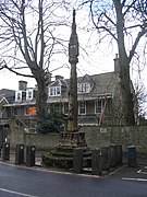 Market Cross
 -
 A newer housing estate, Blackmore Road, looking towards Boyle Close.
 -
 A bridleway


References
- ^ a b "Area: Stalbridge (Parish). Key Figures for 2011 Census: Key Statistics". Neighbourhood Statistics. Office for National Statistics. Retrieved 5 February 2015.
- ^ Jones, Daniel (1919). An English Pronouncing Dictionary. London: Dent. p. 353.
- ^ Stalbridge Town Council, 2005. Introduction. Accessed 2005-12-30.
- ^ a b Michael Pitt-Rivers, 1966. Dorset. London: Faber & Faber.
- ^ a b The Dorset Page, "Stalbridge."
- ^ "Stalbridge History Trail" (PDF). Stalbridge. Retrieved 8 December 2018.
- ISBN 1-874336-96-2
- ^ ISBN 0-86350-020-X
- ^ "Area profile for Stalbridge & Marnhull - Dorset Council". gi.dorsetcouncil.gov.uk. Retrieved 24 February 2024.
- ^ "Blackmore". ukcensusdata.com. Retrieved 28 February 2015.
- ^ StreetCheck. "Interesting Information for Stalbridge, Sturminster Newton, DT10 2PP Postcode". StreetCheck. Retrieved 30 October 2018.
- ^ a b "Stalbridge (Dorset, South West England, United Kingdom) - Population Statistics, Charts, Map, Location, Weather and Web Information". www.citypopulation.de. Retrieved 30 October 2018.
- ^ https://www.dorsetforyou.gov.uk/media/163796/Stalbridge-Part-5.2-and-5.4-Eighteenth-nineteenth-and-twentieth-century-February-2011/pdf/Stalbridge_Part_5.2_and_5.4_Eighteenth_nineteenth_and_twentieth_century_February_2011.pdf [bare URL PDF]
- ^ "Stalbridge Park".
- ^ "Stalbridge Street Map".
- ^ "Public Path Diversion Order" (PDF).
- ^ "Stalbridge trailway and nature reserve".
- ^ "Clubs and Societies".
- ^ "Full Freeview on the Mendip (Somerset, England) transmitter". UK Free TV. 1 May 2004. Retrieved 6 December 2023.
- ^ "Full Freeview on the Rowridge (Isle Of Wight, England) transmitter". UK Free TV. 1 May 2004. Retrieved 6 December 2023.
- ^ "Abbey104". Retrieved 6 December 2023.
External links
![]() Media related to Stalbridge at Wikimedia Commons
Media related to Stalbridge at Wikimedia Commons
- Stalbridge Info Community Website
- Stalbridge Town Council official website
- Stalbridge Genealogy site

| International | |
|---|---|
| National | |