
Sugut River
| Sugut River | |
|---|---|
Mount Kinabalu National Park in Ranau District | |
The Sugut River (
Conservation efforts
Some of the distinctive features of the Sugut River landscape include the dry land forest on
silvered langurs, sun bear, wild pig as well as variety of bird species, including 43 species of freshwater fish.[1] The Trusan Sugut of the river mouth is part of the Sugut Conservation Area (SCA), which was initially gazetted as a Class II commercial forest and later reclassified as a Class I Protection Forest on 24 December 2014.[5][6] In 2015, the World Wide Fund for Nature (WWF) recording the importance of the waterway for villagers as part of a three-year freshwater ecosystem conservation project of the WWF.[7]
Features
The river flows from the Mount Kinabalu system through an extensive alluvial plain before arriving at the Sulu Sea. Along the river also located the Trusan Sugut Forest Reserve.[1][6]
-
 Signboard of Timbulus Village beside the river
 -
-
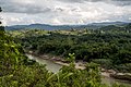
 The river with surrounding vegetation
 -
 Vehicle bridge passing through the river


See also
References
- ^ The Free Library. 1999. Retrieved 24 July 2019.
The Sugut (approximately 178 km long) is the largest river in northeast Sabah. From its high altitude origins in the Kinabalu Range, it flows through an extensive alluvial plain before arriving at the Sulu Sea. At the coast, there is a tidal swamp (stretching for about 8 km of the river course) with the banks lined by a growth of nipah palms and mangrove trees.
- ^ "National Register of River Basins [List of River Basin Management Units (RBMU) – Sabah]" (PDF). Department of Irrigation and Drainage, Malaysia. 2003. p. 34. Retrieved 24 July 2019.
- ^ a b Felix Tongkul (2015). "Status of Mount Kinabalu Water Catchments after the June 2015 Ranau Earthquake – Lessons Learned" (PDF). Sabah Forestry Department, Malaysia. p. 7/67. Archived from the original (PDF) on 24 July 2019. Retrieved 24 July 2019.
- ^ a b "The River Rangers of Sugut, Ranau". World Wide Fund for Nature. 22 March 2016. Retrieved 24 July 2019.
Mount Kinabalu is a major contributor to ecosystems in Sabah with several major river systems originating from this region, namely Labuk River, Sugut River & Kadamaian River.
- ^ "Sugut Conservation Area [Introduction]". Sabah Forestry Department, Malaysia. Archived from the original on 24 July 2019. Retrieved 24 July 2019.
- ^ a b "Trusan Sugut (Protection) Forest Reserve" (PDF). Sabah Forestry Department, Malaysia. Retrieved 24 July 2019.
- ^ Ruben Sario (22 August 2015). "Sungai Sugut villagers to photograph river under conservation project". The Star. Retrieved 24 July 2019.
Further reading
- "Kompendium (Data dan Maklumat Asas JPS)" [Compendium (DID Basic Data and Information)] (PDF) (in Malay). Department of Irrigation and Drainage, Malaysia. 2018: 26. Archived from the original (PDF) on 24 May 2019. Retrieved 24 July 2019.
{{cite journal}}: Cite journal requires|journal=(help)
External links
 Media related to Sugut River at Wikimedia Commons