
Szydłów
Szydłów | ||
|---|---|---|
Town | ||
 The Kraków Gate in Szydłów | ||
|
Car plates TSZ | | |
| Website | www.szydlow.pl | |
Szydłów[2][3][4] [ˈʂɨdwuf] is a fortified town in Staszów County, Świętokrzyskie Voivodeship, in southeastern Poland. It is the seat of the gmina (administrative district) called Gmina Szydłów. It lies approximately 13 kilometres (8 mi) west of Staszów and 43 km (27 mi) south-east of the regional capital Kielce.[5]
Szydłów's history dates to the 12th century. The town contains several tourist attractions, including several buildings and churches dating to the 14th century and the ruins of a castle from the same period, and the 16th-century Szydłów Synagogue. The first official inventory of important buildings in Poland, A General View of the Nature of Ancient Monuments in the Kingdom of Poland, led by Kazimierz Stronczyński from 1844 to 1855, describes the Szydłów Synagogue as one of Poland's architecturally notable buildings.[6]
Location
Szydłów is located in
History
First mention of Szydłów comes from the year 1191, in documents of Sandomierz Collegiate church. At that time, the village was owned by Polish Kings, located along the Vistula merchant road, which was of major importance in the late Middle Ages. On July 1, 1329, Szydłów was incorporated as a town on Środa Śląska town law (see also: Magdeburg rights).
In the mid-14th century, King
Good times came to an end in the first half of the 17th century. In 1630 Szydłów was burned by rebellious soldiers of fortune, who were not paid their salaries. Unable to enter the fortified town, the mercenaries set the suburbs on fire, and the blaze reached Szydłów.
After the Third Partition of Poland (1795), Szydłów was annexed by the Austrian Empire. After the Polish victory in the Austro-Polish War of 1809, it was regained by Poles and included within the short-lived Duchy of Warsaw, within which it became a county seat. After the duchy's dissolution in 1815, it became part of Russian-controlled Congress Poland, and in 1850, Russian authorities liquidated Szydłów County, merging it with Stopnica County. In 1869, as a punishment for participation of residents in the January Uprising, Szydłów was reduced to the status of a village.
.jpg)
In 1929 Szydłów, already part of Kielce Voivodeship, had 2,246 inhabitants, of which 30% were Jews.
Following the joint German-Soviet
In 1960 the population was 1,402. On 1 January 2019, Szydłów regained its town status.
Points of interest
- Medieval town center, with a 700-meter long defensive wall. Out of three gates, only Kraków Gate still exists.
- St. Stanisław Church (14th century)
- Gothic All Saints Church (14th–15th century)
- 14th-century Royal Castle in Szydłów, rebuilt in the 16th century. Main building of the complex is in ruins, currently the castle has a library and a museum. It is entered through a 17th-century gate.
- Ruins of the Holy Spirit Church and Hospital (16th century)
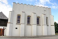
- Late-Renaissance synagogue (16th century), which now houses a Jewish Culture Museum.
-
 Saint Władysław Church
 -
 All Saints Church
 -
 Old Church ruins
 -
 Courtyard of the Castle
 -
 Szydłów Castle
 -


1.jpg)


Demography
According to the
Table 1. Population level of village in 2002—by age group[1] SPECIFICATION Measure
unitPOPULATION
(by age group in 2002)TOTAL 0–9 10–19 20–29 30–39 40–49 50–59 60–69 70–79 80 + I. TOTAL person 1,054 118 172 135 126 175 122 67 86 53 — of which in % 100 11.2 16.3 12.8 12 16.6 11.6 6.4 8.2 5 1. BY SEX A. Males person 534 67 96 81 59 88 63 21 35 24 — of which in % 50.7 6.4 9.1 7.7 5.6 8.3 6 2 3.3 2.3 B. Females person 520 51 76 54 67 87 59 46 51 29 — of which in % 49.3 4.8 7.2 5.1 6.4 8.3 5.6 4.4 4.8 2.8
Figure 1. Population pyramid of village in 2002 — by age group and sex[1]
Table 2. Population level of village in 2002 — by sex[1] SPECIFICATION Measure
unitPOPULATION
(by sex in 2002)TOTAL Males Females I. TOTAL person 1,054 534 520 — of which in % 100 50.7 49.3 1. BY AGE GROUP A. At pre-working age person 249 140 109 — of which in % 23.6 13.3 10.3 B. At working age. grand total person 610 325 285 — of which in % 57.9 30.8 27.1 a. at mobile working age person 394 210 184 — of which in % 37.4 19.9 17.5 b. at non-mobile working age person 216 115 101 — of which in % 20.5 10.9 9.6 C. At post-working age person 195 69 126 — of which in % 18.5 6.5 12

See also
- The Lesser Polish Way
References
- ^ GUS. 10 March 2011.
- )
- ISBN 83-7000-071-1.
- ^ "Szydłów, wieś, gmina Szydłów, powiat staszowski, województwo świętokrzyskie" [Szydłów, village, Szydłów Commune, Staszów County, Świętokrzyskie Province, Poland]. Topographical map prepared in 1:10,000 scale. Aerial and satellite orthophotomap (in Polish). Head Office of Geodesy and Cartography, Poland, Warsaw. 2011. geoportal.gov.pl. Retrieved 27 April 2011.
- ^ "Central Statistical Office (GUS) - TERYT (National Register of Territorial Land Apportionment Journal)" (in Polish). 2008-06-01.
- ^ Heaven's Gates; Wooden synagogues in the Territories of the Former Polish-Lithuanian Commonwealth, Maria and Kazimierz Piechotka, Wydawnictwo Krupski i S-ka, Warsaw, 2004, p. 174
- ^ Województwo sandomierskie w drugiej połowie XVI wieku; Cz.1, Mapy, plany (in Polish). Warszawa: Wydawnictwo Naukowe PWN. 1993. p. 4.
- ISBN 978-0-253-35599-7.
External links
 Media related to Szydłów (województwo świętokrzyskie) at Wikimedia Commons
| Town and seat |  | |
|---|---|---|
| Villages | ||
| Parts of villages |
| |
| Hamlets of villages |
| |