
Talk:Battle of Posada
 | Battle of Posada was one of the Warfare good articles, but it has been removed from the list. There are suggestions below for improving the article to meet the good article criteria. Once these issues have been addressed, the article can be renominated. Editors may also seek a reassessment of the decision if they believe there was a mistake. | |||||||||||||||||||||
| ||||||||||||||||||||||
| This article is rated Start-class on Wikipedia's content assessment scale. It is of interest to the following WikiProjects: | ||||||||||||||||||||||||||||||||||||||||||||||||||||||||||||||||||||||||||
| ||||||||||||||||||||||||||||||||||||||||||||||||||||||||||||||||||||||||||


Good Article passing
I passed this article into the realm of "good articles" because I think it meets all 6 requirements at
14:56, 17 March 2008 (UTC) Wikipedia:WikiProject Military history/Assessment/Battle of Posada- Thanks a lot! --talk) 18:40, 17 March 2008 (UTC)]
- Thanks a lot! --
Due to clearly not meeting the requirement of "NPOV" this should not be considered a "good article." — Preceding unsigned comment added by 2A02:2F07:4109:1F00:5D4E:683D:D3F7:CB5F (talk) 10:24, 17 December 2022 (UTC)
- And it has been delisted from being a good article since 2021... you're replying to a comment from 2008... Alin2808 (talk) 14:11, 17 December 2022 (UTC)
Charles I Robert of Hungary ?
The lead and the template use the form Charles I Robert of Hungary. Is there any evidence that this form of his name has ever been used except within this aricle and derivations from it? Jan1naD (talk • contrib) 22:12, 9 November 2009 (UTC)
not enough detail and missing ref's
The article doesn't go into the necessary background of what the conflict was technically about. Also, many lines have been tagged for references without response. 50.111.45.222 (talk) 03:03, 12 November 2021 (UTC)
GA Reassessment
- This discussion is transcluded from Talk:Battle of Posada/GA1. The edit link for this section can be used to add comments to the reassessment.
Update After seven days of no response from other editors, and per the reasons laid out below, I'm downgrading this article from GA-class to start-class. Gug01 (talk) 06:08, 19 November 2021 (UTC)
The Battle of Posada needs a lot of work and improvement to merit its status as a Good Article. Specifically, I find the article fails the following criteria right now (please see the GA Table for reference):
- 1a - The article's prose has great room for improvement across the board. One example that comes to mind is the use of the word "variant," but that's merely one example; the entire prose is clunky and could be improved.
- 1b - The article's lead section is massively deficient in particular, as it's exceedingly short, doesn't introduce the context of the article, and doesn't discuss the aftermath in any detail whatsoever.
- 2a - There are literally citation needed tags in a Good Article. This is unacceptable, and would be grounds for a quickfail, which I haven't done only because I believe in providing an opportunity for us (the community) to work together to improve articles rather than punitively docking them.
- 2b - Again, there are citation needed tags.
- 3a - Very limited discussion of the battle itself, no discussion of the political context or military campaign prelude, and very rudimentary discussion of the aftermath of the battle, which was enormous.
- 3b - The article currently goes into unnecessary deep use of quotations, including unnecessary information as well as too little information overall.
- 4 - The article relies on only three sources, all of which represent old scholarship and none of which seem to represent the Hungarian perspective of the battle. There's a wealth and diversity of sources on this pivotally-important battle online, none of which are reflected here.
- 5 - see GATable.
- 6a - Images lack US-specific copyright justification, though this problem should be relatively easy to fix given how old the images are.
- 6b - Caption prose could be improved and condensed, and many captions ought to be moved into the main text. Choices in images are rather poor and better aesthetics could be achieved.
The Battle of Posada is pivotal to Romanian history; it's a shame the article on
While the article might've met criteria in 2008 when Wikipedia was a much less-developed encyclopedia (though even then it seems there was no formal review of the article), it certainly doesn't meet them in this moment. In the table below I've inputted passes and fails to illustrate the current status of the article: Gug01 (talk) 04:14, 12 November 2021 (UTC)
| Rate | Attribute | Review Comment |
|---|---|---|
| 1. Well-written: | ||
| 1a. the prose is clear, concise, and understandable to an appropriately broad audience; spelling and grammar are correct. | ||
| 1b. it complies with the list incorporation .
|
||
| 2. Verifiable with no original research: | ||
| 2a. it contains a list of all references (sources of information), presented in accordance with the layout style guideline .
|
||
| 2b. reliable sources are cited inline. All content that could reasonably be challenged, except for plot summaries and that which summarizes cited content elsewhere in the article, must be cited no later than the end of the paragraph (or line if the content is not in prose). | ||
| 2c. it contains no original research. | ||
| 2d. it contains no copyright violations or plagiarism. | ||
| 3. Broad in its coverage: | ||
| 3a. it addresses the main aspects of the topic. | ||
| 3b. it stays focused on the topic without going into unnecessary detail (see summary style). | ||
| 4. Neutral: it represents viewpoints fairly and without editorial bias, giving due weight to each. | ||
| 5. Stable: it does not change significantly from day to day because of an ongoing edit war or content dispute. | Though there aren't edit wars per se, editors over the years have continuously chipped away at parts of this article they don't like without replacing with something new, which decreases the article's stability. Gug01 (talk) 04:18, 12 November 2021 (UTC) | |
| 6. Illustrated, if possible, by media such as audio :
| ||
| 6a. media are tagged with their copyright statuses, and valid non-free use rationales are provided for non-free content. | ||
| 6b. media are relevant to the topic, and have suitable captions .
|
||
| 7. Overall assessment. | See top of page | |
If someone dislikes my edit about the armistice please rewrite it but do not remove it.
Being that there are differing historical sources on this event, and how wikipedia tries to take all sides, we need to add the fact that Romanian sources dispute the armistice. Anyone using Google translate can simply go to the Romanian Language Wikipedia page and notice the difference, and the Hungarian language one as well. I don't want to start ethnic tensions in any way, so to avoid this I suggest we simply state this is disputed, so that an edit war doesn't begin where either nationality comes in editing the page back and forth because of "their version". 2A02:2F07:4109:1F00:5D4E:683D:D3F7:CB5F (talk) 16:12, 16 December 2022 (UTC)
- Sure, but that is no way to edit Wikipedia, the way you did it. For one, Wikipedia is NOT a reliable source (]
Yeah, except you literally just removed it, exactly like I specifically asked you not to do. If you can please just add the sources quoted in the Romanian Language wiki and leave a line saying it is disputed. I am not a wikipedian or a writer I am just trying to help, so can someone who knows what their doing take this over? — Preceding unsigned comment added by 2A02:2F07:4109:1F00:5D4E:683D:D3F7:CB5F (talk) 10:21, 17 December 2022 (UTC)
- Sure, if you can give me the source. On the Ro-wiki article it only says that A.D. Xenopol doubted an armistice happened, but there is no citation. Only at the end the book "Istoria Românilor din Dacia Traiană" by A.D. Xenopol is mentioned, but that's it, no page, no chapter, nothing else, Alin2808 (talk) 14:09, 17 December 2022 (UTC) so how can you be sure that's what it says in there?
Alin, here is the quote from the English language articje: king and Basarab agreed to an armistice, with the condition that the latter would provide guides who knew the way out of the mountains and would lead the army back to the Hungarian plain by the shortest route.[5] that number 5"source is a book entirely in Hungarian, just a page and an author name, that's it.how can you be sure that's what it says in there? See my point?
- @2A02:2F07:4109:1F00:5D4E:683D:D3F7:CB5F: First of all, yes, that's the source and that's one way of citing sources. It has the author name, it has the page and is fully mentioned in the references with further details (book title, ISBN, publisher). If you cared enough to look into it, you'll find that the reference is: "Długosz, Jan & Michael, Maurice. The Annals of Jan Długosz. (Abridged edition). IM Publications, 1997. ISBN 1-901019-00-4". And the source is not in Hungarian, don't know where you even got that from. Długosz (Jan Długosz) was Polish and the source cited is in English, you can search for it by its ISBN, see. So, now you know what you need from a source, why don't you go and bring the source to back the your claim (and the claim on Ro-wiki)? You are more than welcome to do so. Also don't forget to sign your posts with ~~~~ at the end of your reply. Cheers! Alin2808 (talk) 02:59, 18 December 2022 (UTC)
Strange map
Hi @NeimWiki,
I see you like to paint maps, however I think this is similar strange like the Byzantine situation Talk:Byzantine Empire under the Komnenos dynasty#Fake map
Could you tell me why ceratain areas of the Kingdom of Hungary, southern Transylvania (Fogaras) is marked as part of the newly established Wallachia?
Your self painted map: https://upload.wikimedia.org/wikipedia/commons/archive/6/6e/20230715090534%211330VOIVODATE.png
Do you have any academic historical sources and academic history maps regarding this?
Many academic maps contradict your map regarding this area, I do not see any detached region from south Hungary:
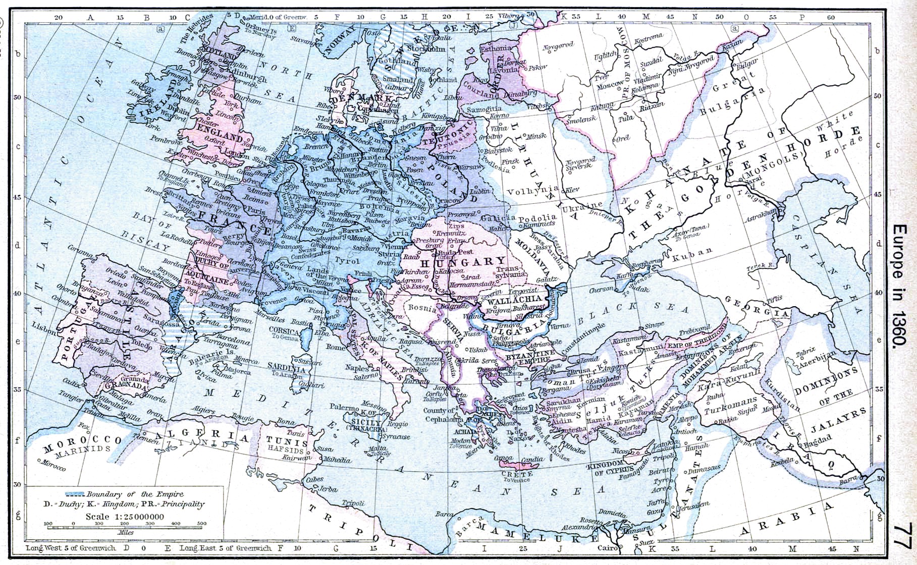
https://commons.wikimedia.org/wiki/File:Europe_in_the_14th_Century.jpg
https://commons.wikimedia.org/wiki/File:Public_Schools_Historical_Atlas_-_Europe_14th_century.jpg
https://www.accordingtophillips.com/uploads/8/1/8/3/81833274/europe-1360_orig.png
https://commons.wikimedia.org/wiki/File:Europe_1360.jpg
Another painted maps contradict your maps:
https://commons.wikimedia.org/wiki/File:Europe_in_1345.png
https://64.media.tumblr.com/4ced68cf04b685e1ec51557b70cb94ab/tumblr_pb5gc1qZFc1rasnq9o1_1280.jpg
Hungarian modern academic maps about medieval Hungary in that period:
https://baloghpet.files.wordpress.com/2019/02/nagy_lajos-1360-1280px.jpg
https://images.slideplayer.hu/41/11284622/slides/slide_25.jpg
https://images.slideplayer.hu/41/11284622/slides/slide_20.jpg
https://ofi.oh.gov.hu/sites/default/files/attachments/01_uralkodoi_gazdasagpolitika.pdf
Your map is "The Carpatho-Danubian-Pontic Space in 1330 AD, after the Battle of Posada", lets see what happened:
Basarab was the vassal of the Hungarian King, but Basarab looted in the south area of Hungary and occupied Szörényvár/Severin (1324). Basarab did not want be a vassal for the Hungarian king, he made ally with Ivan Stephen of Bulgaria. The leader of Transylvania (Szécsényi Tamás) and the leader of Banate of Severin (Széchy Dénes) suggested to the king to attack Basarab. The Hungarian king won and Basarab made again an oath of allegiance. But Basarab attacked again Hungarian territories (1330). Then the Hungarian king reconquered again the Banate of Severin and Basarab sent agent to the Hungarian king and offered money and tax payment. But the King did not accept the offer and attacked Basarab. It was late autumn, the weather and the mountains was not good place and the Hungarian army had food problem so the King made peace again with Basarab. But Basarab lied and the scouts of Basarab lead the Hungarian army in a canyon. So this was a trap and the Vlachs and Cumans, Tatars threwed stones to the army. The battle lasted 4 days long. But the king was able to move home and this was the only lost battle under his reign.
The Banate of Severin was still part of Hungary and Wallachia got a short indepence, but Nicholas Alexander the next ruler of Wallachia in 1344 made an oath of allegiance to king Louis.
I do not know any historical context where the newly establiched Wallachia would have been attacked Hungary in 1330 and would have been conquered southern Transylvania.
If Wallachian voivodes got estates in Hungary it does not mean that regions would have been part of a different country a part of Wallachia.
OrionNimrod (talk) 14:02, 7 July 2023 (UTC)
- Hi again, I see you're making a hobby of tracking my maps now.
- Please refrain from using generalised maps of Europe that do not go into detail on feudal fragmentation, as they are not representative of the medieval period and its governing system. Furthermore, all the maps you have shown have clear errors, so pick better sources next time, since these are not reliable and are extremely simplified, even anachronistic. I won't go into detail about western european errors, but I'll list all errors in the Carpathian Basin:
- https://commons.wikimedia.org/wiki/File:Europe_in_the_14th_Century.jpg
- The only information this map and its description provide is that it depicts Europe in the 14th century, a whole 100 years. Moldavia was founded somewhere between 1345 to 1359, and it was much smaller than depicted, only controlling the north-western corner. Past 1365, there is no reliable evidence, nor claim, that Moldavia had succumbed to Hungary again, instead opting for Polish vassalhood. The map does not include the Despotate of Dobruja that existed from 1325 all the way to the 1400s. The map also does not depict the Banate of Severin, which you have mentioned. It does not even show the well-documented Saxon Seats or the Szekely Seats. I do not see why you've used this map to disprove mine, as its a simplified depiction of a whole century.
- https://commons.wikimedia.org/wiki/File:Public_Schools_Historical_Atlas_-_Europe_14th_century.jpg
- Same situation, but even more simplified and uses hand-drawn borders in Hungary. Please use better sources for your research.
- https://www.accordingtophillips.com/uploads/8/1/8/3/81833274/europe-1360_orig.png
- Your definition of "academic sources and academic maps" is stretched very thin with this one. As per the link, the map depicts Europe in 1360. Ignoring the hand-drawn and simplistic borders,the lack of feudal fragmentation and the fact that its set 30 years after the Battle of Posada, this map depicts Moldavia as part of Lithuania. Its well established that at the time Moldavia was a Hungarian subject and it wouldn't be until 1362 Battle of Blue Waters that Lithuania's control over the Ruthenian Princes would be complete.
- https://upload.wikimedia.org/wikipedia/commons/e/ed/Europe_1360.jpg
- This seems to be the inspiration behind the previous map, except the author put in more effort. Wallachia was not a Hungarian subject in 1360, as Nicolae Alexandru had split from the crown and established himself as in independent orthodox ruler in 1359 by founding the Metropolis of Ungro-Wallachia. And again, this is not representative of the year 1330.
- https://commons.wikimedia.org/wiki/File:Europe_in_1345.png
- You can't seriously be using this as a source.
- https://64.media.tumblr.com/4ced68cf04b685e1ec51557b70cb94ab/tumblr_pb5gc1qZFc1rasnq9o1_1280.jpg
- This is a very simplified and innacurate depiction, besides not showing feudal fragmentation, Basarab I took over the Severin fortress in 1327 and most likely controlled Oltenia way before that. In September 1330, prior to the Battle of Posada, Charles Robert did manage to recapture the fortress of Severin, but that doesn't mean he took over the whole region of Oltenia, nor does anybody claim such a thing as far as I'm aware. If you have anything to rebute that, please provide me a link, hopefully it will be more trustworthy than your previous map. Nonetheless, Charles Robert was defeated in November 1330 at the Battle of Posada, it is a matter of scholarly debate if the Hungarians even managed to hold onto Severin past that date, but even if they did (which I've depicted), they couldn't have held onto the whole region of Oltenia, no document past this date ever implies the Hungarians had any control there.
- https://baloghpet.files.wordpress.com/2019/02/nagy_lajos-1360-1280px.jpg
- The map does not depict feudal fragmentation, and is set 12 years after the Battle of Posada.
- https://m.blog.hu/na/napitortenelmiforras/image/aközépkoralegkirályabb/magyarorszag_anjou_koraban.jpg
- This map does depict some level of feudal fragmentation, all be it not all of it, but it doesn't even show Severin as Hungarian, and isn't even dated. What am I supposed to take from this?
- https://images.slideplayer.hu/41/11284622/slides/slide_25.jpg
- Simplified map, no feudal fragmentation, not a good source, doesn't even depict Severin as Hungarian.
- https://images.slideplayer.hu/41/11284622/slides/slide_20.jpg
- What year is this supposed to be? It doesn't depict feudal fragmentation, what am I supposed to get from it?
- https://ofi.oh.gov.hu/sites/default/files/attachments/01_uralkodoi_gazdasagpolitika.pdf
- Same situation.
- To answer your original question, Fagaras was at its earliest point a Vlach autonomy within Transylvania which afer 1368 became a fief provided by the Hungarian king to the Wallachian Voivode, along with Almas and the Banate of Severin, in exchange for their fealty. This practice most likely began with Hungary's inability to control the isolated district due to its geography and orthodox population. According to legend (which is heavily contested by Romanian historiography), Negru Voda, prince of Fagaras, rode down the Carpathians with his armies and united the Vlach polities to the south, forming Wallachia, an event positioned around 1290. While some Romanian historians contest the historicity of this legend, some have adapted historical documents around it, for example:
- Oltenia and Muntenia were still not united in 1277, a fact which is known because of the mention of Bărbat in a letter of Ladislaus IV from 1285.
- A hungarian document mentions the existence of a "Vlach prince past the mountains" in 1307, which historians have argued could have been Thocomerius, the father of Basarab I, the future founder of Wallachia. There is no indication as to whether or not Oltenia and Muntenia were united at this point, as there are no more mentions of Bărbat or his descendents.
- The timeline that I've managed to compile is that around 1290, the local Voivode of Fagaras united the polities to the south of the Carpathians, either through diplomatic or military means. That Voivode may have been Thocomerius, who preceeded Basarab I.
- The manner in which the Voivode of Wallachia first came to bear the title "Herzog of Fagaras and Amlas" is suspicious, Vladislav I was defeated by the armies of Hungary in 1368, their war ended in him swearing loyalty to the Crown and acquiring this region in exchange, which would be unlikely considering he was decisively defeated. What is possible could have happened is that the King of Hungary instead recognised the Wallachian Voivode's claim to the already held Fagaras, as it was not a profitable province to reconquer. due to its georgraphy and orthodox population. This would hold up with the 1366 Decree of Torda where Orthodox nobles were stripped of their titles and in which vlach subjects are mentioned as melefactors that must be exterminated/expelled.
- If you have anything to add or any other maps you'd like to show me, please refrain from calling them "academic sources" when they're very simplified depictions. The founding of Wallachia is not a subject every historian agrees on, and the matter of who controlled an underpopulated mountainous region is inconsequential. NeimWiki (talk) 15:32, 7 July 2023 (UTC)
- You are very good knowledge in the history of medieval Hungary:@Borsoka, @Norden1990, what is your opinion about the subject? File:1330VOIVODATE.png Do you think it is ok to detach a big chunk (southern Transylvania - Fogaras) from the Hungarian crown in 1330 and attach to Wallachia? If Wallachian voivodes got estates in Hungary it does not mean that regions would have been part of Wallachia. Also those photoshopped self made WP:OR map contradict all Hungarian academic maps what I know regarding of the borders of Hungary.
- _________________________________________
- Hi @NeimWiki,
- this is not my hobby to check you, but your hobby to make photoshopped maps regarding the history of Kingom of Hungary which contradict the Hungarian academic sources. So easy to see instantly the difference between them when you add these maps to Hungarian related topics. I see you do not like the international and Hungarian maps, probably the 14th century is a too big period to show this on only 1 map (I think they are just general average maps), but I am talking about only the southern borders about that Fogaras region which was part of Transylvania not about the banate of Severin. Do you say that your maps are better regarding Hungary than the maps by Hungarian historians? Wiki is not about Wikipedia:No original research, but we need use reliable academic sources.
- Fedual fragmentation? I am talking about the main border shape of the Kingdom not about the county details, and you made a big bulge on the sourthern border of Hungary which is not presented on any academic map. Vlach autonomy does not mean the territory was detached from the Hungarian crown and if Wallachian voivodes got estates in Hungary it does not mean that regions would have been part of Wallachia. Because the Vlach voivode received fiefs from the Hungarian king (Fogaras), he became a subject of the Hungarian king, and his country became a part of Hungary. Fogaras was not part of Wallachia, but Wallachia was part of Hungary. The Byzantines therefore called it Ungro-Valachia.
- What is your evidence that Fogaras was not part of the Hungarian crown in 1330? And how long? (academic sources please)
- _________________________________________
- I think this is out of topic, but lets see:
- "with the 1366 Decree of Torda where Orthodox nobles were stripped of their titles and in which vlach subjects are mentioned as melefactors that must be exterminated/expelled." Not really, sorry I do not read the decree text that Vlach nobles was stripped off from their titles.
- Decree text:
- "because of the evil arts of many malefactors, especially Romanians, who live in that our country (…) to expel or to exterminate in this country malefactors belonging to any nation, especially Romanians."
- Which means all criminals belonging to any nation, which means against every other criminals, so not against all Romanians, just against Romanian criminal, the text emphazied the Romanians because the different way of life caused the conflicts.
- The main source of problems was the relationship between nobles and villains, which was not resolved and was further complicated as claimed by legal and social aspects of the settlement of Romanians in the Hungarian counties. Due to the different ways of life, the constantly increasing population of Romanians in Transylvania led to repeated conflicts with the Hungarians. King Louis I of Hungary visited Transylvania in 1366 to deal with the disorder. The Bishop of Transylvania complained several times that the Romanian kenezes were selling plough fields and meadows as if it were theirs, they oppressed their subjects with new burdens, and they even wanted to extricate themselves from the landlord's authority with threats. Documents from the 14th-15th centuries attest that there were many violent people among the Romanian kenezes. Several times they broke into each other's houses, it was set on fire and the more valuable items were stolen, also murder, arson, and harm on other's livestock are on records. The relationship between the semi-nomadic shepherding Romanian settlers and the permanently settled and farming Transylvanian Hungarians and Saxons was the same as between the farming Hungarians in the Great Hungarian Plains and the wandering Cumans with their flocks. For the intervention of Bishop Coblin, the Saxons and the Romanian kenezes in the Szeben region made an agreement with each other: The Romanian kenezes did not want any compensation for those atrocities which caused by Saxons, and the Saxons also forgave all murders, arsons, devastations and thefts which made by Romanians. Furthermore, the Romanians were not allowed to graze on the Saxon lands without permission and hide the evildoers, because in this case they were also burned. According to that treaty the murderer, the arsonist died by the fire if two witnesses proved it, also who was threatening to arson got the same punishment if seven witnesses testified against him. The Romanians were also obliged that they do not to walk at night and they do not practice archery. These reasons explain the strict measures taken by King Louis the Great in 1366 that the proliferating evildoers must be exterminated. Nevertheless, this did not put an end to the conflicts between Hungarians and Romanians, as is testified by a charter from 1400, which speaks of various crimes (murders, robbery, raping of women, and so on) committed by Romanians. All in all, it took a very long time for the Romanians to become a sedentary people and to grow acquainted with, among other things, the urban way of life. The Hungarians both in Transylvania and in the Danube – Tisza – Maros Region contributed to this process. This is testified by the many Romanian words concerning urban life which are clearly Hungarian loanwords: for example oras < város ‘city’, pirgar < polgár ‘citizen’, balciu < búcsú/vásár ‘fair (market)’, vama < vám ‘customs (dues)’. Part of source: [1][2] OrionNimrod (talk) 16:21, 7 July 2023 (UTC)
- Hi @NeimWiki, I see you engaged to upload more maps which contradict of the international and Hungarian academic maps. According by your photoshopped maps Fogaras/Southern Transylvania was not part of the Hungarian crown through the 14th century. I see you mention the "feudal fragmentation", but I do not see feudal fragmentation in that case, you painted Fogaras as integral part of Wallachia. You also does not show the state borders by thicker line.
- File:1330VOIVODATE.png
- File:1345VOIVODATE.png
- File:1359VOIVODATE.png
- File:1367VOIVODATE.png
- File:1391VOIVODATE.png
- Here, you painted an another region in the center of Transylvania as part of Wallachia, any explanation?
- File:1404VOIVODATE.png

- Fief was a central element in medieval contracts based on feudal law. It consisted of a form of property holding or other rights granted by an overlord to a vassal, who held it in fealty or "in fee" in return for a form of feudal allegiance, services, and/or payments. If the Hungarian king donate estates as overlord to their vassal like the land of Fogaras, it does not mean that region was part of Wallachia but part of the Hungarian crown.
- It is also strange that you happy to paint regions belonged to Hungarian crown as part of Wallachia and part of Moldavia (red in the center of Transylvania), but you do not show the vassal status of Wallachia and Moldavia which were several times Hungarian vassals.
- File:1504VOIVODATE.png
- Please modify your maps, or I will remove them from the articles because those maps are inaccurate in the present form.
- Could you tell me what is the academic base of your map paintings? Or these maps just a fan arts? Like Europa Universalis game: https://www.youtube.com/watch?v=_sfkHkKuLTE OrionNimrod (talk) 11:27, 13 July 2023 (UTC)
- @NeimWiki
- The maps listed by OrionNimrod indeed don't show the particular distribution of estates in medieval countries. Than Hungary would look something like this: https://abtk.hu/images/2021/Hirek/Tortenettudomanyi-Intezet/02.03-Arpad-haz/terkep_cimlap.jpg
- But why is that necessary? All of these were under the Hungarian crown. Or, can you link a map showing that Fogaras was under the Wallachian crown? I don't think so, just look at the Kunság autonomy: it wasn't part of Cumania, but of Hungary. Currently, your argument is: "I don't like your maps, let me figure out the boundaries instead". But you just have to adjust your works to professional sources, unless eventually they will be deleted for unreliability. Two-three small corrections and that won't happen, this whole debate gets solved and people interested in Romania will be provided with useful information. Gyalu22 (talk) 06:41, 15 July 2023 (UTC)
- After more research into the topic, I've discovered the first historical mention of Fagaras dated to 11 March 1291 actually describes it as being donated back to a Hungarian noble after previously being taken from him (presumably by vlachs). Post 1366 the district became a Wallachian possesion inside the Kingdom of Hungary, a well documented fact highlighted on my maps. This could've been resolved much faster had OrionNimrod provided me a source himself, instead of poorly drawn, oversimplified maps and weird takes on historical decrees.
- My previous claim that Fagaras must've been Wallachian at a time prior to 1366 was based on the 17th century chronicle Letopisețul Cantacuzinesc which mentions it as the estate of the legendary founder of Wallachia Negru Voda in 1290, a common narrative among historians. NeimWiki (talk) 08:56, 15 July 2023 (UTC)
- I say again what I said before. The district of Fogaras/Făgăraş was under the Hungarian crown, not under the Wallachian crown. Even if Romanians inhabited or owned the land, that doesn't make it part of one of the Romanian states. Transylvanian Saxony also wasn't part of the Holy Roman Empire. The Hungarian king awarded these lands to the Germans and thus they were his vassals and the lands were under his overlordship. This is an example, the same applies for the Fogaras Vlachs. Gyalu22 (talk) 09:46, 15 July 2023 (UTC)
- Hi @NeimWiki, we are not armchair historians here to use our researches, imaginations and different understanding of history, this is Wiki rule: WP:ORIGINAL, but we need follow and publish the academic historical sources. If there are different modern academic opinions, secondary sources then we can show more opinions.
- You wrote: "Post 1366 the district became a Wallachian possesion inside the Kingdom of Hungary" INSIDE the Kingdom of Hungary, part of the Hungarian crown, not part of Wallachia.
- Here in your previous map we can see Fogaras as integral part of Wallachia, you clearly painted the state borders: https://upload.wikimedia.org/wikipedia/commons/archive/d/d0/20230715090532%211345VOIVODATE.png
- And in other many your maps through in the 14th century Fogaras is part of Wallachia, which is contradict all Hungarian and international history maps as I showed, we can see clearly the state borders there, and that region did not miss from Hungarian medieval state in that period. Those maps were painted by academic scholars and by historians. I saw many times maps in wiki which just a vector graphic copy of an academic map, but this is ok because it follow the original one which can be copyrighted.
- I am ok to collaborate with other users, you can see I did not start edit war to remove your maps fast. This is not a personal offense, if you modify your maps, then ok. I am graphic artist, I know it is a great effort! OrionNimrod (talk) 13:45, 15 July 2023 (UTC)
- The map you linked is of 1345, which as you may realise comes before 1366. Not only that, it is an older version of my map, which I've updated this morning. NeimWiki (talk) 13:55, 15 July 2023 (UTC)
- Hi @NeimWiki, I see you changed it, it was just an example that on that previously map, you clearly emphasized the state borders: South Transylvania was integral part of the Wallachian state. Which cannot be true if I see any Hungarian and international academic maps during the time of King Louis I of Hungary. Anyway, thanks for changing and understanding! OrionNimrod (talk) 14:01, 15 July 2023 (UTC)
- The map you linked is of 1345, which as you may realise comes before 1366. Not only that, it is an older version of my map, which I've updated this morning. NeimWiki (talk) 13:55, 15 July 2023 (UTC)
- I say again what I said before. The district of Fogaras/Făgăraş was under the Hungarian crown, not under the Wallachian crown. Even if Romanians inhabited or owned the land, that doesn't make it part of one of the Romanian states. Transylvanian Saxony also wasn't part of the Holy Roman Empire. The Hungarian king awarded these lands to the Germans and thus they were his vassals and the lands were under his overlordship. This is an example, the same applies for the Fogaras Vlachs. Gyalu22 (talk) 09:46, 15 July 2023 (UTC)
