
Tierra del Fuego
Yaghans |
Tierra del Fuego (/tiˈɛərə dɛl ˈfweɪɡoʊ/, Spanish: [ˈtjera ðel ˈfweɣo]; Spanish for "Land of Fire", rarely also Fireland in English) is an archipelago off the southernmost tip of the South American mainland, across the Strait of Magellan.
The archipelago consists of the main island, Isla Grande de Tierra del Fuego, with an area of 48,100 km2 (18,572 sq mi), and a group of many islands, including Cape Horn and Diego Ramírez Islands. Tierra del Fuego is divided between Argentina, which controls the eastern part of the main island and a few small islands in the Beagle Channel, and Chile, which controls the remaining land area. The southernmost extent of the archipelago is just north of latitude 56°S.
The earliest known human settlement in Tierra del Fuego dates to approximately 8,000 BC.[1] Europeans first explored the islands during Ferdinand Magellan's expedition of 1520. Tierra del Fuego and similar namings stem from sightings of the many bonfires that the natives built.
Settlement by those of European descent and the displacement of the native populations did not begin until the second half of the nineteenth century, at the height of the Patagonian sheep farming boom and of the local gold rush.[2] Today, petroleum extraction dominates economic activity in the north of Tierra del Fuego, while tourism, manufacturing, and Antarctic logistics are important in the south.
History
Prehistory

The earliest human settlement occurred approximately 8,000 BC. The
European exploration

The name Tierra del Fuego was given by the Portuguese explorer Ferdinand Magellan while sailing for the Spanish Crown in 1520; he was the first European to visit these lands. He believed he was seeing the many fires (fuego in Spanish) of the indigenous inhabitants, which were visible from the sea, and that the "Indians" were waiting in the forests to ambush his armada.[4]
In 1525, Francisco de Hoces was the first to speculate that Tierra del Fuego was one or more islands rather than part of what was then called Terra Australis. Francis Drake in 1578 and a Dutch East India Company expedition in 1616 learned more about the geography. The latter expedition named Cape Horn at Hornos Island.
On his first voyage with
European colonization and extinction of Native Americans (1860–1910)
.jpg)
.jpg)
During the second half of the nineteenth century, Salesian Catholic missions were established in Río Grande and Dawson Island.
An 1879 Chilean expedition led by Ramón Serrano Montaner reported large amounts of
Following contact with Europeans, the native Selk'nam and
Following the signing of the Boundary Treaty of 1881, Tierra del Fuego was divided between Argentina and Chile; previously, it had been claimed in its entirety by both countries.
Recent history (1940–present)
In 1945, a division of Chilean
Geography


The archipelago consists of a main island, Isla Grande de Tierra del Fuego, often simply called Tierra del Fuego or Isla Grande, with an area of 48,100 km2 (18,572 sq mi), and a group of smaller islands. Of the main island the westernmost 29,484.7 km2 (11,384 sq mi, 61.43%) belongs to Chile, and 18,507.3 km2 (7,146 sq mi, 38.57%) belongs to Argentina. The archipelago is divided by an east–west channel, the Beagle Channel, immediately south of the main island. The largest islands south of the Beagle Channel are Hoste and Navarino.
The western part of the main island, and almost all the other islands, belong to Chile. They are part of the
Puerto Toro lies a few kilometers south of Puerto Williams. Arguably, it is the southernmost village in the world. The mostly uninhabited islands north and west of the main island are part of Magallanes Province.
The eastern part of the main island and a few small islands in the Beagle Channel belong to Argentina. They are part of the
The
The topography of Tierra del Fuego can be divided into four regions: an outer archipelago region (Spanish: Región Archipielágica) to the south and west, a mountainous region in the south (Spanish: Región Cordillerana),[9] a plains region (Spanish: Región de las Planicies Orientales)[10] plus a sub-Andean zone in-between the last two zones (Spanish: Región Sub-Andina Oriental).[11]
Geology
The geology of the archipelago is influenced by the effects of the
The
Podzols and inceptisols occur beneath Nothofagus betuloides forests in Tierra del Fuego.[15]
Climate

The Tierra del Fuego region has a subpolar
Flora
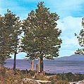
Only 30% of the islands have forests, which are classified as Magellanic subpolar. The northeastern portion of the region is made up of steppe and cool semi-desert.
Six species of tree are found in Tierra del Fuego: canelo or winter's bark (
They are the only forests in the world to have developed in a climate with such cold summers. Tree cover extends very close to the southernmost tip of South America. Winds are so strong that trees in wind-exposed areas grow into twisted shapes, inspiring people to call them "flag-trees". Tree vegetation extends to the southern tip of the region,
- Flora in Tierra del Fuego
-
 Drimys winteri flowers
 -

-
-


Forests from Tierra del Fuego have expanded beyond local importance. These forests have been a source of trees that have been transplanted abroad in places with similar climate, but which originally were devoid of trees, such as the Faroe Islands and nearby archipelagos. Most species were gathered from the coldest places in Tierra del Fuego, mainly sites with tundra borders. This effort resulted in positive changes, as the heavy winds and cool summers in the Faroe Islands did not allow the growth of trees from other regions in the world. The imported trees are used ornamentally, as curtains against wind, and to fight erosion caused by storms and grazing in the Faroe Islands.[17]
Fauna

Among the most notable animals in the archipelago are austral parakeets, gulls, guanacos,[18] South American foxes, kingfishers, Andean condors, king penguins, owls, and firecrown hummingbirds.[19] Isla Grande de Tierra del Fuego is also home to the lizard with the world's southernmost distribution, Liolaemus magellanicus.[20]
North American beavers, introduced during the 1940s, have proliferated and caused considerable damage to the island forests. The governments have established a wide-reaching program to trap and kill beavers in Tierra del Fuego.[21]
Like the mainland of Chile and Argentina to the north, this archipelago boasts some of the finest
Waters adjacent to Tierra del Fuego are very rich in
Economy
Today, the main economic activities of the archipelago are fishing, extraction of natural gas and
Energy production is a crucial economic activity. On the Argentine side of Tierra del Fuego during the period 2005–2010, petroleum and natural gas extraction contributed 20% of the region's economic output.[39]
Tierra del Fuego in the Fine Arts
- Alexander Buchan participated in the 1768–1771 first voyage of James Cook aboard HMS Endeavour, where he was one of the artists in the entourage of botanist Joseph Banks. Endeavour lay at anchor in the Bay of Good Success on 15 January 1769. He took part in an expedition which started from here.
- As a ship painter, Conrad Martens drew and created watercolor paintings in 1833 and 1834 during the second voyage of HMS Beagle in Tierra del Fuego.[40][41]
- The French painter and lithographer Évremond de Bérard illustrated the travel journal "Le Tour du Monde" with Tierra del Fuego motifs in 1861.
- Rockwell Kent painted "more than twenty large pictures of Tierra del Fuego" during his stay there in 1922 and 1923, as he reported in his autobiography It's Me O Lord: The Autobiography of Rockwell Kent.
- The German painter Ingo Kühl traveled three times to Tierra del Fuego, where he created paintings in a cycle entitled Landscapes of the End of the World (2005).[42]
-
 Alexander Buchan Inhabitants of Tierra del Fuego, 1769
 -
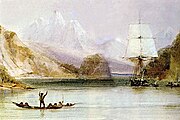 Conrad Martens HMS "Beagle" in Tierra del Fuego, between 1832 and 1836
 -
 Évremond de Bérard Tierra del Fuego, Monte Sarmiento seen from Froward Cape, 1861
 -
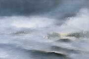 Ingo Kühl Glacier (Beagle Channel), 2005 painted in Punta Arenas


%22_2005.jpg)
See also
- Alberto de Agostini National Park
- Beagle conflict
- Beaver eradication in Tierra del Fuego
- Mamihlapinatapai
- The Voyage of the Beagle
- Tierra del Fuego National Park
- Yaghan language
Notes
- S2CID 161882222.
- ISBN 978-987-99166-9-8. Archivedfrom the original on 23 September 2023. Retrieved 1 March 2016.
- ^ Hogan, C. Michael (4 April 2008). "Bahia Wulaia Dome Middens". Megalithic Portal. Archived from the original on 10 June 2011. Retrieved 20 June 2011.
- ISBN 978-0-06-186588-6.
- ^ a b "Cook Tried to Steal Parson's Life Work" (PDF). The New York Times. 21 May 1910. Archived (PDF) from the original on 18 October 2018. Retrieved 30 May 2011.
- ^ Martinić, Mateo (1982), La Tierra de los Fuegos (in Spanish), Punta Arenas, Chile: Municipalidad de Porvenir, pp. 164–171
- ^ "Historia de Tierra del Fuego" (in Spanish). Tierradelfuego.gov.ar. Archived from the original on 17 July 2011. Retrieved 20 June 2011.
- ^ John Shipton (2004). "Monte Shipton or Monte Darwin?" (PDF). Alpine Journal. London: Alpine Club: 132–142. Archived (PDF) from the original on 19 April 2014. Retrieved 28 March 2012.
- ^ Pisano (1977), p. 124
- ^ Pisano (1977), p. 128
- ^ Pisano (1977), p. 125
- ^ Menichetti, M.; Lodolo, E.; Tassone, A. (March 2008). "Structural geology of the Fuegian Andes and Magallanes fold-and-thrust belt – Tierra del Fuego Island". Geologica Acta. 6 (1). Archived from the original on 18 July 2011. Retrieved 20 June 2011.
- ^ Hervé, Francisco; Miller, Hubert; Pimpirev Christo. 2003. Patagonia – Antarctica Connections before Gondwana Break-Up in Antarctica Contributions to Global Earth Sciences. Chapter 5.1
- .
- ^ Martínez Crovetto, Raúl. 1968. Estudios Etnobotánicos. Nombres de plantas y su utilidad según los indios Onas de Tierra del Fuego, Revista de la Facultad de Agronomía y Veterinaria de la Universidad del Nordeste, Corrientes, Argentina
- ^ Højgaard, A., J. Jóhansen, and S. Ødum (eds) 1989. A Century of Tree Planting in the Faroe Islands, Føroya Frodskaparfelag, Tórshavn.
- doi:10.2305/IUCN.UK.2016-1.RLTS.T11186A18540211.en.)
{{cite journal}}: Cite journal requires|journal=(help - doi:10.2305/IUCN.UK.2016-3.RLTS.T22687857A93172170.en.)
{{cite journal}}: Cite journal requires|journal=(help - S2CID 252717680.
- ^ Strieker, Gary (9 July 1999). "Argentina eager to rid island of beavers". Cable News Network. Archived from the original on 3 March 2008. Retrieved 30 June 2007.
- ^ Schiavini, Adrian. "ARGENTINA. PROGRESS REPORT ON CETACEAN RESEARCH, JUNE 2000 TO JUNE 2001". Archived from the original on 10 July 2019.
- ^ "Hoy en Rio Grande, Tierra del Fuego (ballena)". 18 April 2009. Archived from the original on 5 May 2014.
- ^ Goodall, R. Natalie P.; Benegas, G. L.; Dellabianca, N.; Riccialdelli, L.; Pimper, E. L. (17 January 2014). "The Presence of Southern Right Whales off Eastern Tierra del Fuego, 1987–2011" (PDF). Archived from the original (PDF) on 5 May 2014. Retrieved 6 May 2014.
- ^ "Whale Watching in the Southern Cone – Argentina". Archived from the original on 31 May 2014. Retrieved 5 May 2014.
- ^ "Whale Watching in the Southern Cone – Gallery". Archived from the original on 31 May 2014. Retrieved 5 May 2014.
- ^ "Blue Whale (Balaenoptera musculus) on Tierra del Fuego Check List". Archived from the original on 17 September 2016.
- ^ "Minke Whale (Sei Whale?)". 9 December 2011. Archived from the original on 24 June 2016 – via Flickr.
- ^ "Minke Whale (Balaenoptera acutorostrata) on Tierra del Fuego Check List". Archived from the original on 4 January 2018.
- ^ "Record of a dwarf minke whale (Balaenoptera acutorostrata) in northern Brazil" (PDF). Archived (PDF) from the original on 5 May 2014.
- ^ "Scotia Sea: Part 5. The Great Marine Mammals". Archived from the original on 5 May 2014. Retrieved 5 May 2014.
- ^ "Sailing to the Sea Lions and Les Eclaireurs Lighthouse in Catamarans". Archived from the original on 20 January 2013.
- ^ "Southern Sea Lions: Tierra del Fuego, Argentina". 25 September 2011. Archived from the original on 5 May 2014.
- ^ "Mark Horrell: Tierra del Fuego". 28 February 2003. Archived from the original on 4 November 2016 – via Flickr.
- ^ "Ballenas en el Canal de Beagle". Archived from the original on 5 May 2014.
- ^ "Ushuaia Photo: leopard seal". Archived from the original on 20 September 2016.
- ^ "Expedition Uncovers Wildlife Wonders at Tierra del Fuego". 25 February 2011. Archived from the original on 9 July 2011.
- ^ "Cruceros Australis – Fjords of Tierra del Fuego, Patagonia & Cape Horn, Punta Arenas – Ushuaia – Punta Arenas". Archived from the original on 5 May 2014.
- ^ "Instituto Nacional de Estadística y Censos". Archived from the original on 6 April 2007. Retrieved 28 April 2018.
- ISBN 0-521-21822-5
- ^ "A Voyage of Sketches: The Art of Conrad Martens". Cambridge Digital Library. 2014. Archived from the original on 11 December 2021 – via www.youtube.com.
- ^ Kühl, Ingo (2006). "Landschaften am Ende der Welt / Paisages del fin del mundo / mit einem Text von / con un texto de Antonio Skármeta". I. Kühl. Archived from the original on 11 March 2022. Retrieved 16 April 2022 – via Deutsche Nationalbibliothek.
References
- Bridges, Lucas. 1948. Uttermost Part of the Earth. Reprint with introduction by Gavin Young, Century Hutchinson, 1987. ISBN 0-7126-1493-1
- Keynes, Richard. 2002. Fossils, Finches and Fuegians: Charles Darwin's Adventures and Discoveries on the Beagle, 1832–1836. HarperCollinsPublishers, London. Reprint: 2003.
- Bollen, Patrick. 2000. "Tierra del Fuego" B/W Photobook. Lannoo Publishers, Tielt, Belgium. ISBN 90-209-4040-6
- Pisano Valdés, E. (1977). "Fitogeografía de Fuego-Patagonia chilena. I.-Comunidades vegetales entre las latitudes 52 y 56º S". Anales del Instituto de la Patagonia (in Spanish). Vol. VIII. Punta Arenas.
{{cite book}}: CS1 maint: location missing publisher (link)
External links
- Official website of Argentine Tierra del Fuego
- Chile Cultural Society – Tierra del Fuego
- Chisholm, Hugh, ed. (1911). . Encyclopædia Britannica (11th ed.). Cambridge University Press.
| International | |
|---|---|
| National | |
| Other | |