
Titiwangsa station
3°10′24″N 101°41′44″E / 3.173296°N 101.695555°E
AG3 SP3 MR11 PY17 Titiwangsa | |||||||||||||||||||||||||||||||||||
|---|---|---|---|---|---|---|---|---|---|---|---|---|---|---|---|---|---|---|---|---|---|---|---|---|---|---|---|---|---|---|---|---|---|---|---|
| Coordinates | 3°10′23″N 101°41′43″E / 3.17306°N 101.69528°E | ||||||||||||||||||||||||||||||||||
| Owned by | Prasarana Malaysia (LRT & Monorail)
MRT Corp (MRT) | ||||||||||||||||||||||||||||||||||
| Operated by | Rapid Rail | ||||||||||||||||||||||||||||||||||
| Line(s) | 3 Ampang 4 Sri Petaling 8 KL Monorail 12 Putrajaya 13 Circle MRT (Proposed) | ||||||||||||||||||||||||||||||||||
| Platforms | 2 side platforms (LRT) 2 side platforms (Spanish solution) (Monorail) 1 island platform (MRT) | ||||||||||||||||||||||||||||||||||
| Tracks | 2 (LRT) 1 (Monorail) 2 (MRT) | ||||||||||||||||||||||||||||||||||
| Construction | |||||||||||||||||||||||||||||||||||
| Structure type | AG3 SP3 MR11 CC08 (Elevated) PY17 (Underground) | ||||||||||||||||||||||||||||||||||
| Platform levels | 4 | ||||||||||||||||||||||||||||||||||
| Parking | Not available | ||||||||||||||||||||||||||||||||||
| Other information | |||||||||||||||||||||||||||||||||||
| Station code | AG3 SP3 MR11 PY17 CC08 | ||||||||||||||||||||||||||||||||||
| History | |||||||||||||||||||||||||||||||||||
| Opened | 6 December 1998 (LRT)[1] 31 August 2003 (Monorail) 16 March 2023 (MRT) | ||||||||||||||||||||||||||||||||||
| Opening | 2028-2030 (MRT Circle Line) | ||||||||||||||||||||||||||||||||||
| Services | |||||||||||||||||||||||||||||||||||
| |||||||||||||||||||||||||||||||||||
Titiwangsa station is a rapid transit
Situated on
The station is planned to be an integration station with the Circle Line of the KVMRT project.[2]
History
First opened in 1998 as part of the former STAR LRT line's second phase of development, the station was intended to connect Titiwangsa to other parts of the city and surrounding areas. Under Phase 2 of the STAR line, a 15 km track with 11 stations was built to serve the northern and southern areas of Kuala Lumpur to cater for the Commonwealth Village and the National Sports Complex in Bukit Jalil, during the 1998 Commonwealth Games in Kuala Lumpur. At that time, Titiwangsa station was named as "Tun Razak" station.[3]
LRT station

The Titiwangsa LRT station is a
Monorail station

The Monorail station is a later addition in the area that is intended to connect the LRT station with the
MRT station
The underground MRT station is the latest addition to the integrated station, serving the
The station's theme encapsulates the essence of "rhythm", capturing a dynamic and harmonious arrangement characterized by regular, repetitive patterns of movement or sound, emphasizing elements such as pattern, flow and tempo. The selected color palette for the theme is "ocean blue", inspired by Titiwangsa, a district named after the Titiwangsa Lake Park, which was previously an area of tin mines.[5]
An elevated station has also been planned for the MRT3 Circle Line in the future, making it as the next metro hub in the city with 5 integrated transit lines.
Integrated LRT and Monorail station
Seamless transfer and fare integration was achieved on 1 March 2012 when the "paid-area" or restricted areas of both the LRT and monorail stations, which previously operated as two separate stations, were linked up with a footbridge, allowing passengers to transfer without needing to buy new tokens for the first time since the monorail became operational in 2003.
Details
Station layout
| L2 | LRT Ampang and Sri Petaling Lines Platform Level | Side platform | |
| Platform 1 (→) | |||
| Platform 2 3 Ampang towards AG18 Ampang or 4 Sri Petaling towards SP31 Putra Heights (←) | |||
| Side platform | |||
| KL Monorail Platform Level | Side platform (Spanish solution) | ||
| Platform 1 & 2 KL Sentral (←)
| |||
| Side platform (Spanish solution) | |||
| L1 | LRT station Concourse | Faregates, Ticketing Office, Ticketing Machine, Station Control, Unpaid Area Escalators to/from Street Level | |
| Paid Area Linkway | Paid-area Pedestrian Overhead Walkway Linking Concourses of the KL Monorail and LRT Ampang, Sri Petaling Line and MRT Putrajaya Line stations | ||
| Monorail Station Concourse | Faregates, Ticketing Office, Ticketing Machine, Station Control, Unpaid Area Escalators to/from Street Level | ||
| MRT Station Concourse | MRT Putrajaya Line Concourse, Faregates | ||
| G | Street Level | Titiwangsa Bus Interchange, Escalators to Monorail and LRT Station Concourses | |
| B1 | Faregates, Exit to MRT Station Entrance B | ||
| B2 | MRT Station Platform Level | Platform 1: 12 Putrajaya towards PY41 Putrajaya Sentral (→) | |
| Island platform | |||
| Platform 2: 12 Putrajaya towards PY01 Kwasa Damansara (←) | |||
Exits and entrances
| Entrance | Location | Destination | Picture |
|---|---|---|---|
| A | Intersecrtion of Jalan Pekeliling Lama and Jalan Tun Razak | Jalan Tun Razak, KPJ Sentosa Hospital, Damai Hospital, Hab Bas Titiwangsa, Kompleks Damai, Tun Razak 2 Residence, Tun Razak Residence, Kuala Lumpur Hospital, Jalan Setiawan, Jalan Cemur, Jalan Taiping, Jalan Bidor, Pusat Transit Gelandangan Kuala Lumpur | 
|
| B | Jalan Tun Razak (towards westbound) near Gombak River Bridge | Jalan Tun Razak, Hab Bas Titiwangsa, Titiwangsa Taxi Terminal, Jalan Batu Bata, Jalan Larut, Jalan Sultan Azlan Shah
|

|
| C | Intersection of Jalan Tun Razak and Jalan Pahang Timur | Jalan Tun Razak, MRT Titiwangsa via Entrance A, LRT Titiwangsa via Entrance D, KPJ Tawakkal Hospital | 
|
| D | Jalan Tun Razak (towards eastbound) near Gombak River Bridge | Jalan Pahang Barat, Jalan Tun Razak, MRT Titiwangsa via Entrance A, MR Titiwangsa via Entrance C, Menara PJD, Jalan Sentul Manis, Jalan Kampar, Jalan Sentul, SMK Maxwell | .jpg)
|
| E | Off Jalan Pangkor | Hab Bas Titiwangsa (Titiwangsa Bus Hub), Jalan Pangkor, Jalan Ahmad, Jalan Lumut, Jalan 1/68D, Jalan Datuk Haji Eusoff, Wisma PMB, Menara Teo Chew | 
|
| PJD | Menara PJD | Menara PJD | .jpg)
|
| A | Intersection of Jalan Pahang Barat and Jalan Tun Razak | Jalan Pahang Barat, Jalan Tun Razak, LRT Titiwangsa via Entrance D, MR Titiwangsa via Entrance C, Menara PJD, Jabatan Penguatkuasaan Dewan Bandaraya Kuala Lumpur (DBKL)
|
_01.jpg)
|
| B | Umnamed road from Jalan Pahang Barat towards Jalan Tun Razak | Jalan Tun Razak, Masjid Balai Islam, Institut Perubatan Respiratori Hospital Kuala Lumpur, Wat Meh Liew Thai Buddhist Temple, Pahang Roundabout, Titiwangsa Lake Park | _01.jpg)
|
| C Deffered |
Intersection of Jalan Pekeliling Lama and Jalan Tun Razak | Jalan Pekeliling Lama, Hab Bas Titiwangsa, Tun Razak 2 Residence, Tun Razak Residence, Jalan Ahmad, Kuala Lumpur Hospital, MR Titiwangsa via Entrance A or B | 
|
Bus hub
Titiwangsa Hub Hab Titiwangsa | |
|---|---|
| Intercharge bus hub | |
.jpg) | |
| General information | |
| Other names | hj |
| Location | Jalan Pekeliling, Selangor Malaysia |
| Bus operators |
|
| Connections | |
The Titiwangsa station is located close to a bus hub, also known as the Pekeliling Bus Station, just north beside the Gombak River and simply consisting of several rows of shelters. The station serves
.| No. | Terminus | Operator | Ref. | Image | ||
|---|---|---|---|---|---|---|
| Ayer Panas | ↺ | Hab Titiwangsa | Rapid Bus | [6] | ||
| Hab Titiwangsa | ⇌ | Awana Bus Terminal | Wawasan Sutera | |||
| Titiwangsa | ↺ | KLCC | Rapid Bus | [7] | 
| |
| Terminal Maluri | ⇌ | Hab Titiwangsa | Rapid Bus | [8] | ||
| Hab Titiwangsa | ↺ | KL Sentral
|
Kuala Lumpur City Hall (Go KL City Bus) | [9] | 
| |
| Hab Titiwangsa | ↺ | Bukit Bintang | Kuala Lumpur City Hall (Go KL City Bus) | [10] | 
| |
| Hab Titiwangsa | ↺ | MINDEF | Kuala Lumpur City Hall (Go KL City Bus) | [11] | 
| |
Around the station
Gallery
-
 The exterior of the KL Monorail's Titiwangsa terminal station, with the terminating line's buffer stop.
 -
 The platform level of theAmpang Line's Titiwangsa station.
 -
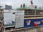
 Construction of the MRT station in October 2021
 -
 Titiwangsa MRT underground station
 -
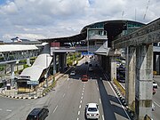
 Titiwangsa bus hub, 2023
 -
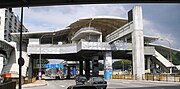
 Titiwangsa Monorail station
_(exterior),_Kuala_Lumpur.jpg)
_07.jpg)
_03.jpg)


References
- ^ "Rapid KL | DI SINI BERMULA KISAH REL URBAN MALAYSIA …". Facebook.
- ^ "MYMRT | MRT Corp - Official webpage for the Klang Valley My Rapid Transit". www.mymrt.com.my. Archived from the original on 2017-06-27. Retrieved 2017-05-29.
- ^ Chia Mui Wee (1998). Persepsi pengguna terhadap penggunaan perkhidmatan pengangkutan Sistem Transit Aliran Ringan Sdn. Bhd (in Malay). Universiti Malaya: Bahagian Pentadbiran Perniagaan,Fakulti Ekonomi dan Pentadbiran, Universiti Malaya. p. 87.
- ^ "MYMRT | MRT Corp - Official webpage for the Klang Valley My Rapid Transit". www.mymrt.com.my. Archived from the original on 2017-05-25. Retrieved 2017-05-29.
- ^ "MRT SENTUL BARAT STATION (4)". online.fliphtml5.com. Retrieved 2023-06-28.
- ^ "Peta laluan, jadual, hentian untuk laluan 254 - Ayer Panas Chow Kit". Moovit. 31 July 2018. Archived from the original on 19 April 2019. Retrieved 23 March 2020.
- ^ "Peta laluan, jadual, hentian untuk laluan 302 - Hab Titiwangsa Suria KLCC". Moovit. 22 November 2017. Archived from the original on 19 April 2019. Retrieved 23 March 2020.
- ^ "Peta laluan, jadual, hentian untuk laluan 402 - Hab Titiwangsa". Moovit. 21 November 2017. Archived from the original on 26 April 2019. Retrieved 24 March 2020.
- ^ "Peta laluan, jadual, hentian untuk laluan GoKL Hab Titiwangsa KL Sentral". Moovit. Archived from the original on 9 May 2019. Retrieved 9 May 2019.
- ^ "Peta laluan, jadual, hentian untuk laluan GoKL Hab Titiwangsa Bukit Bintang". Moovit. Archived from the original on 9 May 2019. Retrieved 9 May 2019.
- ^ "Peta laluan, jadual, hentian untuk laluan GoKL Hab Titiwangsa Mindef". Moovit. 2 March 2019. Archived from the original on 9 May 2019. Retrieved 9 May 2019.