
U.S. Route 63 in Arkansas
Route map:
This article is about the section of U.S. Route 63 in Arkansas. For the entire route, see
North end  US 63 in Mammoth Spring
Location Country United States State Arkansas Counties Union, Bradley, Cleveland, Jefferson, Arkansas, Prairie, Monroe, Woodruff, Cross, Poinsett, Craighead, Greene, Lawrence, Sharp, Fulton Highway system
US 63 at the southern terminus of I-530 in Pine Bluff 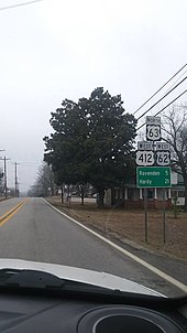
US Highway 62 joins US 63 and 412 in Imboden
US 167 at Junction City


 US 79 in Pine Bluff
 US 70 in Hazen
 I-40 north of Hazen
 US 49 in Brinkley


 Future I-57 / US 67 in Hoxie
 US 412 near Walnut Ridge
 US 62 in Imboden
| ← | → |
U.S. Highway 63 (US 63) is a north-south U.S. highway that begins in
US 167 in Junction City. The highway runs north through the eastern part of the state, serving rural areas of South Arkansas and the Arkansas Delta, as well as Pine Bluff and Jonesboro. The highway exits the state at Mammoth Spring traveling into Missouri
.
Route description
U.S. 63 enters into Arkansas from Louisiana concurrent with
US 270. US 63 passes through the rural Cleveland County, then enters into Jefferson County
.
.jpg)
In Jefferson County, US 63 serves the city of
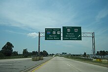
US 49 north to Jonesboro. US 63 leaves US 49 and follows I-555 until I-555 terminates, together serving as a bypass for southern Jonesboro. In Hoxie, US 63 intersects with US 67 (Future I-57). Northwest of here near Portia the highway overlaps with US 412
.
In Imboden, US 62 joins this overlap. In Hardy, US 63 leaves the two highways. In Mammoth Spring, US 63 crosses into Missouri, traveling to West Plains.

History
Portions of U.S. 63 in northern Arkansas have their origins in the work of the
1927 Mississippi flood and the realignment of U.S. 63 in 1967. Northwest of Tyronza, Old U.S. 63 runs for about 1-1/4 miles of original concrete pavement;[1] it was listed on the National Register of Historic Places in 2009.[2] Four bridges built in the 1920s (three before the 1927 flood and one after, are also on the National Register; three southeast of Marked Tree, and one southeast of Tyronza.[3][4]
On March 11, 2016, Interstate 555 (I-555) was dedicated after a new resolution passed in December 2015 allowing farm equipment to use the roadway when it became an interstate.
In April 2019,
AASHTO to reroute US 63 concurrent with US 49 between Brinkley and Jonesboro, eliminating the concurrencies with I-55 and I-555, and part of the concurrency with I-40.[5] The rerouting took effect in 2021.[6] However, a small section of US 63 in Jonesboro was redesignated as I-555 on November 23 of the same year, making US 63 partly concurrent with I-555 again.[7]
Major intersections
| County | Location | mi | km | Exit | Destinations | Notes | ||
|---|---|---|---|---|---|---|---|---|
US 167 south – Ruston | Louisiana state line | |||||||
| | 10.4 | 16.7 | South end of AR 7 overlap | |||||
South Arkansas Regional Airport | Interchange; US 82 exit 22 | |||||||
| 15.0 | 24.1 | 15 | US 167B north (Hillsboro Street) | Interchange | ||||
| 16.2 | 26.1 | Interchange; North end of US 167 / AR 7 overlap; US 63 north follows exit 16 | ||||||
| Old Union | 22.5 | 36.2 | ||||||
| | 33.2 | 53.4 | ||||||
AR 600 – Moro Bay State Park | ||||||||
| | 48.9 | 78.7 | South end of AR 160 overlap | |||||
| North end of AR 160 overlap | ||||||||
| 53.4 | 85.9 | US 63B south – Hermitage | ||||||
| Carmel | 62.2 | 100.1 | South end of AR 8 overlap | |||||
| | 64.1 | 103.2 | ||||||
| Warren | 65.4 | 105.3 | ||||||
| 65.9 | 106.1 | US 63B north | ||||||
| 66.9 | 107.7 | US 278B | ||||||
| 68.4 | 110.1 | North end of AR 8 overlap | ||||||
| 69.0 | 111.0 | US 63B south / AR 189 south – Monticello | ||||||
| Cleveland | Rye | 74.8 | 120.4 | South end of AR 35 overlap | ||||
| Pansy | North end of AR 35 overlap | |||||||
| Calmer | South end of AR 114 overlap | |||||||
| North end of AR 114 overlap | ||||||||
| Jefferson | | South end of AR 54 overlap | ||||||
| Pinebergen | North end of AR 54 overlap | |||||||
US 63B north – Little Rock | South end of I-530 / US 65 / US 79 overlap; US 63 south follows exit 43 | |||||||
| | 44 | AR 530 south – Star City, Monticello | ||||||
| Pine Bluff | 46 | North end of I-530 / US 65 overlap; South end of US 65B overlap; US 63 north follows exit 46 | ||||||
US 65B north / Harding Street / Market Street | North end of US 65B overlap | |||||||
| | ||||||||
UAPB | ||||||||
Altheimer Business District | ||||||||
| Arkansas | Humphrey | |||||||
| | ||||||||
| | ||||||||
| | Phillips Community College | |||||||
US 79 north (West Michigan Street) – Clarendon, Arkansas County Agricultural Museum | North end of US 79 overlap | |||||||
| | De Witt, Clarendon | |||||||
| Prairie | | |||||||
| | South end of AR 86 overlap | |||||||
| Siedenstricker | North end of AR 86 overlap | |||||||
| Hazen | South end of US 70 overlap | |||||||
Hazen Business District | North end of US 70 overlap | |||||||
| South end of I-40 overlap; US 63 south follows exit 193 | ||||||||
| See I-40 (Exit 193 - 216) See US 49 (Arkansas milepost 54.97 to 125.53) See I-555 (Exit 45 to 49) | ||||||||
AR 18 west) / I-555 | Interchange; North end of freeway; North end of AR 18 overlap; northern terminus of I-555 | |||||||
| | Bono Business District | |||||||
| | ||||||||
| | Bono Business District | |||||||
| Greene |
No major junctions | |||||||
| Lawrence | Sedgwick | South end of AR 228 overlap | ||||||
| North end of AR 228 overlap | ||||||||
| Walnut Ridge | ||||||||
US 63B north – Hoxie | ||||||||
| Interchange; South end of US 412 overlap, exit 121A-B. | ||||||||
| Hoxie | Interchange | |||||||
| | Hoxie Business District | |||||||
| | ||||||||
Powhatan Courthouse, Lake Charles | Interchange | |||||||
| South end of AR 117 overlap | ||||||||
| North end of AR 117 overlap | ||||||||
| Imboden | South end of US 62 overlap | |||||||
| Randolph |
No major junctions | |||||||
| Lawrence | Ravenden | |||||||
AR 58E west – Williford | ||||||||
| | ||||||||
| Hardy | South end of AR 175 overlap | |||||||
US 63B north – Hardy, Historic District | ||||||||
| North end of US 62 / US 412 / AR 175 overlap | ||||||||
| Fulton | Mammoth Spring | |||||||
| | Missouri state line | |||||||
| 1.000 mi = 1.609 km; 1.000 km = 0.621 mi | ||||||||
See also
- National Register of Historic Places in Poinsett County, Arkansas
References
- ^ "NRHP nomination for Highway A-7, Tyronza Segment" (PDF). Arkansas Preservation. Retrieved 2014-11-24.
- ^ "National Register Information System". National Register of Historic Places. National Park Service. March 13, 2009.
- ^ "NRHP nomination for Highway A-7, Bridges Historic District" (PDF). Arkansas Preservation. Retrieved 2014-11-24.
- ^ "NRHP nomination for Highway A7, Ditch No. 6 Bridge" (PDF). Arkansas Preservation. Retrieved 2014-11-24.
- ^ "Application from ArDOT to AASHTO Highways Special Committee on U. S. Route Number" (PDF). April 23, 2019.
- .
- ^ "Highway 63 in Jonesboro redesignated as I-555". Talk Business & Politics. 23 November 2021. Retrieved 22 May 2023.
External links
KML is from Wikidata