
Vouvant
Vouvant | |
|---|---|
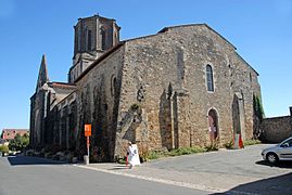
 The Notre-Dame de l'Assomption church in Vouvant | |
 Coat of arms | |
Location of Vouvant  | |
 Vouvant  Vouvant | |
| Coordinates: 46°34′20″N 0°46′11″W / 46.5722°N 0.7698°W | |
| Country | France |
| Region | Pays de la Loire |
| Department | Vendée |
| Arrondissement | Fontenay-le-Comte |
| Canton | La Châtaigneraie |
| Intercommunality | Pays-de-Fontenay-Vendée |
| Government | |
| • Mayor (2022–2026) | Xavier Philippot[1] |
| Area 1 | 20.20 km2 (7.80 sq mi) |
| Population (2021)[2] | 834 |
| • Density | 41/km2 (110/sq mi) |
| Time zone | UTC+01:00 (CET) |
| • Summer (DST) | UTC+02:00 (CEST) |
| INSEE/Postal code | 85305 /85120 |
| Elevation | 35–110 m (115–361 ft) |
| 1 French Land Register data, which excludes lakes, ponds, glaciers > 1 km2 (0.386 sq mi or 247 acres) and river estuaries. | |
Vouvant (French pronunciation: [vu.vɑ̃]) is a commune in the department of Vendée, in the Pays de la Loire region in western France.
Vouvant is labelled as Les Plus Beaux Villages de France (since 1988), Petites Cités de Caractère, and the village has obtained two flowers out of five in the Concours des villes et villages fleuris.
It is the only remaining fortified town in the Vendée. Its inhabitants are called Vouvantais. Over 10% of the population of Vouvant is British owing to a gradual occupation or purchase of real estate by English families.
Sites and monuments
Several sites and monuments are present in Vouvant :
- Walled enclosure of the French Ministry of Culturesince 1927. The city fortifications has been protected as a monument historique since 1984.
- Notre-Dame de l'Assomption Church, classed as a monument historique in 1840 by Prosper Mérimée, built from the 11th century under the leadership of William V, Duke of Aquitaine :
- Théodelin's nave : 11th century ;
- crypt : 11th century, modified in the 12th century and rebuilt during restoration works in 1882–1884 for the ceiling ;
- square gable wall of the north portal, choir, apse and two small apses : second half of the 12th century ;
- triangular gable wall of the north portal and Gothic sculptures : 1458–1464 ;
- transept and the first three spans of the nave : wholly rebuilt during restoration works in 1882–1890.
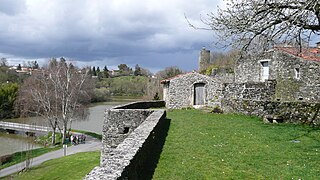
- Medieval bridge (dated from the 13th-15th centuries for the oldest parts), protected as a monument historique since 1927.
- Reproduction of the Grotto of Lourdes, on the bank of the Mère river. Realized in 1958.
- Public washing place (19th century).
- Forest of Mervent-Vouvant, Vendée's largest forest (5,518 ha (13,640 acres)).
-
 Tour Mélusine
 -
 Tour Mélusine
 -
 Notre-Dame de l’Assomption church
 -
 North portal of the church
 -
 Théodelin's nave
 -
 Jardin du prieuré
 -
 Entrance of Vouvant
 -
 Fortifications and the Mère river
 -
 Mère river, with the Tour Mélusine in the background
 -
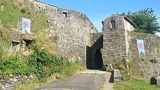 Postern Gate
 -
 Postern Gate
 -
 View from the Postern Gate
 -
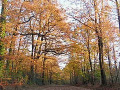 Forest of Mervent-Vouvant
 -
 The river, in the heart of the forest


See also
References
- ^ "Répertoire national des élus: les maires" (in French). data.gouv.fr, Plateforme ouverte des données publiques françaises. 6 June 2023.
- ^ "Populations légales 2021". The National Institute of Statistics and Economic Studies. 28 December 2023.
Wikimedia Commons has media related to Vouvant.
| International | |
|---|---|
| National | |
This Vendée geographical article is a stub. You can help Wikipedia by expanding it. |