
Tourtour
Tourtour | |
|---|---|
 Overview of Tourtour | |
 Coat of arms | |
Location of Tourtour  | |
 Tourtour  Tourtour | |
| Coordinates: 43°35′25″N 6°18′11″E / 43.5903°N 6.3031°E | |
| Country | France |
| Region | Provence-Alpes-Côte d'Azur |
| Department | Var |
| Arrondissement | Brignoles |
| Canton | Flayosc |
| Government | |
| • Mayor (2020–2026) | Fabien Brieugne[1] |
| Area 1 | 28.69 km2 (11.08 sq mi) |
| Population (2021)[2] | 585 |
| • Density | 20/km2 (53/sq mi) |
| Time zone | UTC+01:00 (CET) |
| • Summer (DST) | UTC+02:00 (CEST) |
| INSEE/Postal code | 83139 /83690 |
| Elevation | 375–904 m (1,230–2,966 ft) (avg. 635 m or 2,083 ft) |
| 1 French Land Register data, which excludes lakes, ponds, glaciers > 1 km2 (0.386 sq mi or 247 acres) and river estuaries. | |
Tourtour (French pronunciation: Var department in the Provence-Alpes-Côte d'Azur region in southeastern France. It is a member of Les Plus Beaux Villages de France ("The most beautiful villages of France") association.
Geography
Called "the village in the sky of Provence" (le village dans le ciel de Provence), Tourtour overlooks a large part of Provence from the town of Fréjus along the Mediterranean coast in the east to the Montagne Sainte-Victoire, a favorite subject of the painter Paul Cézanne, in the west.
In popular culture
The Bastide de Tourtour, a local hotel, was prominently featured in the film Day of the Jackal and the 2010 ITV series "Monte Carlo or bust".
Sister cities
Gallery
- Sights of Tourtour
-
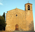 The Romanesque Saint-Denis Church
 -
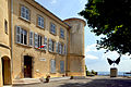 Tourtour town hall
 -
 Grimaldi tower


See also
References
- ^ "Répertoire national des élus: les maires" (in French). data.gouv.fr, Plateforme ouverte des données publiques françaises. 13 September 2022.
- ^ "Populations légales 2021". The National Institute of Statistics and Economic Studies. 28 December 2023.
External links
Wikimedia Commons has media related to Tourtour.
- Village de Tourtour
- (in German) Pictures Tourtour
| International | |
|---|---|
| National | |
| Geographic | |
This Var geographical article is a stub. You can help Wikipedia by expanding it. |