
Walter Liberty Vernon
FRIBA | |
|---|---|
 | |
| 10th New South Wales Government Architect | |
| In office 1 August 1890 – 11 August 1911 | |
| Preceded by | George McRae |
| Succeeded by | James Barnet |
| 10th Mayor of East St Leonards | |
| In office 9 February 1887 – 18 February 1888 | |
| Preceded by | George Ranken |
| Succeeded by | Patrick William Glacken |
| Alderman of the Borough of East St Leonards | |
| In office 4 March 1885 – 29 July 1890 | |
| Ward | East Ward (1889–1890) |
| Alderman of the Municipality of North Sydney | |
| In office 29 July 1890 – 10 February 1891 | |
| Personal details | |
| Born | 11 August 1846 Colonel |
| Commands | |
Early life
Vernon was born 11 August 1846 in
Career in Australia
Vernon established a private practice in Sydney, and then partnered with William Wardell from 1884 until 1889. Vernon assisted with works already in progress, designed buildings and supervised Wardell's Melbourne projects in 1884–85. Vernon was an alderman on East St Leonards Municipal Council in 1885–90, serving a single term as Mayor from 1887 to 1888.[2][3] When the Borough of East St Leonards amalgamated to form the Municipality of North Sydney on 29 July 1890, Vernon was an Alderman of the new council, but did not seek re-election when his term expired in February 1891.[4] Elected a fellow of the Royal Institute of British Architects in 1885, he joined the (Royal) Art Society of New South Wales in 1884, (Sir) John Sulman's Palladian Club and the Institute of Architects of New South Wales in 1887, and the Sydney Architectural Association in 1891.[1]
On 1 August 1890 Vernon was appointed as the New South Wales Government Architect, however his staff numbers were reduced significantly.[5] Vernon showed that the system of design competitions were twice as expensive and the activities of this office were boosted in 1894 when extra funding was committed as a way of creating relief work during the Depression of the 1890s.
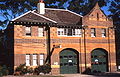
As an architect practising in Australia, Vernon favoured what were later known as the Federation styles, such as the Free Classical, Arts and Crafts, and Free Style.
Examples of the former were his fire station in St Johns Road,
For more substantial public buildings, Vernon continued the tradition whereby such buildings were designed in a Classical style. Notable examples were the Art Gallery of New South Wales, the Mitchell Library (part of the State Library), Central railway station and Newcastle Court House.[7] The Art Gallery has been described as "masterly symmetry featuring Ionic colonnades."[6] Central Station has been described as "the grandest railway station in Australia."[7]: p.2/108
Vernon also designed significant additions to existing buildings, such as Customs House in Circular Quay; Randwick Police Station; the Chief Secretary's Building, Sydney; Balranald Post Office; Armidale Post Office; and the former Premier's Office, Sydney. His office was also responsible for the public decorations during the Federation celebrations of 1901.
in 1906, he advocated
He retired as New South Wales Government Architect in 1911 and returned to private practice, establishing a partnership with
Death and funeral
Following the amputation of a leg, Vernon died of
Legacy
Vernon had an outstanding career as an architect, with many of his buildings being listed on various national and/or state heritage registers.
Partial list of works
The following buildings and structures were designed either in part or in full by Vernon, that are listed on active Commonwealth or State heritage registers include:
| Work | Suburb/city | Type | Style | Completed | Involvement | Image | Heritage registers |
Notes |
|---|---|---|---|---|---|---|---|---|
| Admiralty House | Kirribilli |
Government residence | Victorian Italianate | 1891-92 | Italianate enlargements | _Admiralty_House-1.jpg) |
|
[15][16][17][18] |
| Annandale Post Office | Annandale | Post office | Federation Free Classical | 1896 | Architect |  |
|
[19][20][21] |
| Armidale Post Office | Armidale |
Post office | Federation Queen Anne |
1897 | Loggia only |  |
|
[22][23] |
| Art Gallery of New South Wales | The Domain, Sydney | Art gallery | Federation Academic Classical | 1895-1906 |
|
 |
|
[24][25] |
| ASN Co building | 1-5 Hickson Road, The Rocks |
Warehouse | Pre-Federation Anglo Dutch | 1884-1885 |
|
 |
|
[26][27][28] |
| Australian Museum | College Street, Sydney | Natural history museum | 1896-1899 | South wings | .jpg) |
|
[29][30] | |
Banco Road Court |
St James Road, Sydney | Court house | Federation Free Classical | 1895-1896 | Architect |  |
|
[31][32][33] |
| Bloomfield Hospital | Orange | Hospital | 1923-1931 | Initial design only | NSW Register | [34] | ||
| Broken Hill Post Office | Broken Hill | Post office | Federation Arts and Crafts |
1890-1892 | Alterations and additions | .jpg) |
|
[35][36][37] |
| Brooklyn Hotel (Façade preserved as the Johnson's Building) |
229 George Street, The Rocks | Public hotel | Free Federation Style | 1912-1912 | Architect |  |
|
[38][39] |
| Burwood Post Office (former) | Burwood | Post office | Federation Anglo Dutch Revival | 1892 | Architect (assisted by George Oakeshott) |
 |
|
[40][41] |
| Casino Post Office | Casino | Post office |
|
1879 | Alterations and additions |
|
[42][43][44] | |
| Central Local Court House | 98 Liverpool Street, Sydney | Court house (and former police station) |
Federation Free Classical | 1892 |
|
Police_Courts_Sydney-1.jpg) |
|
[45][46] |
| Central railway station | Railway Square | Terminus railway station |
|
1901-1906 |
|
 |
|
[47][48][49] |
Colonial Secretary's building |
121 Macquarie Street, Sydney | Government administration | Victorian Second Empire | 1894-1896 |
|
.jpg) |
|
[50][51] |
| Coroner's Court (former) | 102-104 George Street, The Rocks | Coroner's Court and morgue |
Federation Free Style | 1906-1908 | Architect |
|
[52][53] | |
| Kitchen block, Cumberland Hospital and Parramatta Female Factory (former) |
Parramatta/Westmead | Hospital |
|
1892-1893 | Alterations and additions |
|
[54][55][56][57][58] | |
| Customs House | Alfred Street, Sydney | Customs house |
1896-1903 | Alterations and additions | .jpg) |
|
[59][60][61] | |
| David Berry Hospital Precinct | Berry | Hospital | 1909 |
|
NSW Register | [62] | ||
| Glen Innes Post Office | Glen Innes | Post office | Federation Arts and Crafts |
1895-1896 | Architect |  |
|
[63][64][65] |
| Health Department Building (former) | 93-97 Macquarie Street, Sydney | Government administration (now a hotel) |
Federation Free Style | 1896-1898 | Architect |
|
[66][67] | |
| Hestock | 14 Crescent Street, Hunters Hill |
House | Federation Arts & Crafts | 1885 | Architect |
|
[68][69] | |
| Inverell Post Office | Inverell |
Post office | Federation Arts and Crafts |
1904 | Architect |
|
[70][71] | |
| Leura (now part of Cranbrook School, Sydney) |
24 Victoria Road, Bellevue Hill | House | Federation Queen Anne |
1891 |
|
NSW Register | [72] | |
| Lidcombe Hospital Precinct | Lidcombe | Hospital | 1885-1906 |
|
|
[73][74][75] | ||
Liverpool TAFE College (former Liverpool Hospital, Block F) |
Liverpool | Teacher's college | 1902-1907 | Alterations and additions | .jpg) |
|
[76][77] | |
| Long Bay Correctional Centre | Malabar | Gaol | 1899-1914 | Architect |  |
NSW Register | [78] | |
| Maitland Court House | Maitland | Court house | Federation Free Classical | 1895 | Architect |
|
[79][80] | |
| Millers Point Post Office | Millers Point | Post office | Federation Free Classical | 1891 | Architect |
|
[81][82] | |
| Mining Museum (former) | 36-64 George Street, The Rocks | Museum | Federation Warehouse | 1902-1909 | Architect |  |
NSW Register | [83] |
| Mitchell Library, State Library of NSW | Sydney | Library | Federation Academic Classical | 1906-1910 | Architect |  |
|
[84][85] |
| Mudgee Post Office | Mudgee | Post office | Victorian Free Classical | 1902 | Alterations and additions |  |
|
[86][87][88][89] |
| Newcastle Court House | Newcastle | Court house | Victorian Italianate | 1902 | Alterations and additions |  |
|
[90][91] |
| Newcastle Customs House | Newcastle | Customs house | Italian Renaissance Revival | 1899 | Alterations and additions |  |
|
[92][93] |
| Newcastle Post Office | Newcastle | Post office | Federation Academic Classical | 1900-1903 | Architect |  |
|
[94][95][96][97] |
| Paddington Post Office | Paddington | Post office |
|
c. 1885 | Alterations and additions |  |
|
[98][99][100] |
| Parkes Post Office | Parkes | Post office | 1901-1903 | Alterations and additions | .jpg) |
|
[101][102] | |
| Pyrmont Post Office | Pyrmont | Post office | Federation Free Style | 1901 | Architect |  |
|
[103][104][105] |
| Randwick Post Office (former) and Jubilee Fountain |
Randwick | Post office | Federation Free Style | 1897-1898 | Architect | .jpg) |
|
[106][107] |
Registrar-General's Building (also called the Land Titles Office) |
Prince Albert Road, Sydney | Government administration | Federation Gothic | 1908-1913 | Principal architect (with E. H. Farmer) |
 |
|
[108][109] |
| Royal Botanic Gardens Herbarium and Shelter House |
The Domain | Herbarium and cottage | 1899 |
|
|
[110][111][112] | ||
| Royal Edward Victualling Yard Group | Darling Island, Pyrmont | Naval warehouse and ordinance stores (former) |
Federation Warehouse | 1904-1912 | Architect (Buildings A, B and C) |
.jpg) |
|
[113][114] |
| Shop and Residence | 182 Cumberland Street, The Rocks | Shop and residence | Classic Free Style Edwardian | 1911-1912 | Architect (assisted by E. L. Drew) |
NSW Register | [115] | |
| Silverwater Correctional Complex, Erwin House and Engineer's Cottage |
Silverwater |
Gaol | 1911-1918 | Alterations and additions | NSW Register | [116] | ||
| Singleton Post Office (former) | Singleton | Former post office | 1899 | Alterations and additions |
|
[117][118] | ||
InterContinental Hotel |
117-119 Macquarie Street, Sydney | Government administration |
|
1898-1900 |
|
.jpg) |
|
[119][120] |
Other places were Vernon had involvement, either in part or in full, that are not listed on active Commonwealth or State heritage registers include the Anderson Stuart building,
Gallery
-
 Pyrmont Fire Station
 -
 Randwick Fire Station
 -
 Darlinghurst Fire Station
 -
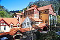 Jenolan Caves House, in the Blue Mountains
Pyrmont_Fire_Station-1.jpg)

Darlinghurst_Fire_Station-b.jpg)

See also
References
- ^ ISSN 1833-7538. Retrieved 12 October 2017.
- New South Wales Government Gazette. No. 97. New South Wales, Australia. 10 March 1885. p. 1596. Retrieved 11 April 2019 – via National Library of Australia.
- ^ "BOROUGH OE EAST ST. LEONARDS". New South Wales Government Gazette. No. 91. New South Wales, Australia. 15 February 1887. p. 1120. Retrieved 10 April 2019 – via National Library of Australia.
- ^ "MUNICIPAL". The Daily Telegraph. New South Wales, Australia. 15 January 1891. p. 6. Retrieved 22 June 2020 – via Trove.
- ^ "Government Gazette Appointments and Employment". New South Wales Government Gazette. No. 429. New South Wales, Australia. 12 August 1890. p. 6280. Retrieved 11 April 2019 – via National Library of Australia.
- ^ a b c d A Pictorial Guide to Identifying Australian Architecture. Apperly (Angus and Robertson Publishers). 1994.
- ^ a b c d e f g The Heritage of Australia. Macmillan Company. 1981.
- ^ "The Federal Capital". Yass Evening Tribune. 31 May 1906. p. 2. Retrieved 15 March 2022.
- ^ "FEDERAL CAPITAL SITE". Sydney Morning Herald. 30 May 1906. p. 9. Retrieved 15 March 2022.
- ^ "The halfway house – Parliament buildings". New Zealand History Online. Retrieved 12 February 2012.
- ^ "New Parliament Buildings". Thames Star. Vol. XLVII, no. 10273. 28 September 1911. p. 1. Retrieved 12 February 2012.
- ^ "Late Colonel Vernon". The Sydney Morning Herald. 20 January 1914. p. 7. Retrieved 27 March 2014.
- ^ "Northbourne Avenue, Vernon Circle, Commonwealth Avenue, State Circle, Capital Circle, Canberra Avenue, Hume Place and Monaro Highway (National Route 23) – Acton to Fyshwick". Road Photos & Information: Australian Capital Territory. Paul Rands. Retrieved 21 September 2014.
- ^ "Vernon Circle". ACT Government, Environment and Planning. Retrieved 21 September 2014.
- ^ "Admiralty House Garden and Fortifications (CHL) (Place ID 105399)". Australian Heritage Database. Australian Government. Retrieved 12 October 2017.
- ^ "Admiralty House Garden and Fortifications (Place ID 102281)". Australian Heritage Database. Australian Government. Retrieved 12 October 2017.
- ^ "Admiralty House and Lodge (CHL) (Place ID 105398)". Australian Heritage Database. Australian Government. Retrieved 12 October 2017.
- ^ "Admiralty House and Lodge (Place ID 2890)". Australian Heritage Database. Australian Government. Retrieved 12 October 2017.
- .
- ^ "Annandale Post Office (CHL) (Place ID 105489)". Australian Heritage Database. Australian Government. Retrieved 12 October 2017.
- ^ "Annandale Post Office (Place ID 1697)". Australian Heritage Database. Australian Government. Retrieved 12 October 2017.
- .
- ^ "Armidale Post Office (Place ID 290)". Australian Heritage Database. Australian Government. Retrieved 13 October 2017.
- .
- ^ "Art Gallery of NSW (Place ID 2349)". Australian Heritage Database. Australian Government. Retrieved 13 October 2017.
- .
- .
- ^ "Australasian Steam Navigation Company Building (Place ID 2123)". Australian Heritage Database. Australian Government. Retrieved 12 October 2017.
- .
- ^ "Australian Museum (Place ID 1896)". Australian Heritage Database. Australian Government. Retrieved 12 October 2017.
- .
- ^ "Banco Court Building (Place ID 1902)". Australian Heritage Database. Australian Government. Retrieved 15 October 2017.
- ^ "St James Road Banco Court". Sydney Living Museums. Government of New South Wales. 2017. Retrieved 15 October 2017.
- .
- .
- ^ "Broken Hill Post Office (CHL) (Place ID 105499)". Australian Heritage Database. Australian Government. Retrieved 13 October 2017.
- ^ "Broken Hill Post Office (Place ID 544)". Australian Heritage Database. Australian Government. Retrieved 13 October 2017.
- .
- ^ "Brooklyn Hotel (Place ID 2391)". Australian Heritage Database. Australian Government. Retrieved 13 October 2017.
- .
- ^ "Burwood Post Office (former) (Place ID 3356)". Australian Heritage Database. Australian Government. Retrieved 13 October 2017.
- .
- ^ "Casino Post Office (CHL) (Place ID 105492)". Australian Heritage Database. Australian Government. Retrieved 13 October 2017.
- ^ "Casino Post Office (Place ID 217)". Australian Heritage Database. Australian Government. Retrieved 13 October 2017.
- .
- ^ "Central Police Courts (Place ID 2194)". Australian Heritage Database. Australian Government. Retrieved 15 October 2017.
- ^ "Central Railway Station (Place ID 2196)". Australian Heritage Database. Australian Government. Retrieved 12 October 2017.
- .
- .
- .
- ^ "Chief Secretarys Building (Place ID 1824)". Australian Heritage Database. Australian Government. Retrieved 12 October 2017.
- .
- ^ "Coroner's Court (former) (Place ID 2463)". Australian Heritage Database. Australian Government. Retrieved 12 October 2017.
- ^ "Former Female Factory Precinct Parramatta (Place ID 106234)". Australian Heritage Database. Australian Government. Retrieved 12 October 2017.
- .
- .
- .
- ^ "Kitchen Block (Place ID 3056)". Australian Heritage Database. Australian Government. Retrieved 12 October 2017.
- .
- ^ "Sydney Customs House (former) [CHL] (Place ID 105436)". Australian Heritage Database. Australian Government. Retrieved 12 October 2017.
- ^ "Sydney Customs House (former) (Place ID 1787)". Australian Heritage Database. Australian Government. Retrieved 12 October 2017.
- .
- .
- ^ "Glen Innes Post Office (CHL) (Place ID 105494)". Australian Heritage Database. Australian Government. Retrieved 12 October 2017.
- ^ "Glen Innes Post Office (Place ID 321)". Australian Heritage Database. Australian Government. Retrieved 12 October 2017.
- .
- ^ "Health Department Building (former) (Place ID 2403)". Australian Heritage Database. Australian Government. Retrieved 12 October 2017.
- .
- ^ "Hestock (Place ID 2721)". Australian Heritage Database. Australian Government. Retrieved 15 October 2017.
- .
- ^ "Inverell Post Office (Place ID 10626)". Australian Heritage Database. Australian Government. Retrieved 12 October 2017.
- .
- .
- ^ "Lidcombe Hospital (former) (Place ID 105753)". Australian Heritage Database. Australian Government. Retrieved 12 October 2017.
- ^ "Lidcombe Hospital (former) Group (Place ID 2960)". Australian Heritage Database. Australian Government. Retrieved 12 October 2017.
- .
- ^ "Liverpool Hospital (former) (Place ID 3294)". Australian Heritage Database. Australian Government. Retrieved 12 October 2017.
- .
- .
- ^ "Maitland Courthouse (Place ID 1237)". Australian Heritage Database. Australian Government. Retrieved 12 October 2017.
- .
- ^ "Millers Point Post Office (Place ID 19160)". Australian Heritage Database. Australian Government. Retrieved 12 October 2017.
- .
- .
- ^ "State Library of NSW (Place ID 1847)". Australian Heritage Database. Australian Government. Retrieved 12 October 2017.
- .
- ^ "Mudgee Post Office (CHL) (Place ID 105498)". Australian Heritage Database. Australian Government. Retrieved 12 October 2017.
- ^ "Mudgee Post Office (Place ID 484)". Australian Heritage Database. Australian Government. Retrieved 12 October 2017.
- ^ "Mudgee Post Office Group (Place ID 483)". Australian Heritage Database. Australian Government. Retrieved 12 October 2017.
- .
- ^ "Newcastle Courthouse (Place ID 1297)". Australian Heritage Database. Australian Government. Retrieved 12 October 2017.
- .
- ^ "SCustoms House (former) (Place ID 1306)". Australian Heritage Database. Australian Government. Retrieved 12 October 2017.
- ^ "Newcastle Post Office (CHL) (Place ID 105507)". Australian Heritage Database. Australian Government. Retrieved 12 October 2017.
- ^ "Newcastle Post Office (Place ID 1287)". Australian Heritage Database. Australian Government. Retrieved 12 October 2017.
- ^ "Newcastle Post Office Annex (former) (Place ID 1288)". Australian Heritage Database. Australian Government. Retrieved 12 October 2017.
- ^ "Newcastle Post Office Group (Place ID 1286)". Australian Heritage Database. Australian Government. Retrieved 12 October 2017.
- .
- ^ "Paddington Post Office (CHL) (Place ID 105300)". Australian Heritage Database. Australian Government. Retrieved 15 October 2017.
- ^ "Paddington Post Office (Place ID 19158)". Australian Heritage Database. Australian Government. Retrieved 15 October 2017.
- .
- ^ "Parkes Courthouse Group (Place ID 954)". Australian Heritage Database. Australian Government. Retrieved 13 October 2017.
- .
- ^ "Pyrmont Post Office (CHL) (Place ID 105510)". Australian Heritage Database. Australian Government. Retrieved 12 October 2017.
- ^ "Pyrmont Post Office (Place ID 2040)". Australian Heritage Database. Australian Government. Retrieved 12 October 2017.
- .
- ^ "Randwick Post Office (Place ID 1769)". Australian Heritage Database. Australian Government. Retrieved 12 October 2017.
- .
- ^ "Registrar-General's Building (Place ID 1845)". Australian Heritage Database. Australian Government. Retrieved 15 October 2017.
- .
- ^ "Herbarium, Sydney Botanical Gardens (Place ID 1868)". Australian Heritage Database. Australian Government. Retrieved 15 October 2017.
- ^ "Shelter House, Sydney Botanical Gardens (Place ID 1875)". Australian Heritage Database. Australian Government. Retrieved 15 October 2017.
- .
- ^ "Royal Edward Victualling Yard Group (Place ID 2057)". Australian Heritage Database. Australian Government. Retrieved 15 October 2017.
- .
- .
- .
- ^ "Singleton Post Office and Stables (former) (Place ID 14341)". Australian Heritage Database. Australian Government. Retrieved 15 October 2017.
- .
- ^ "Treasury Building & Premiers Office (Place ID 1829)". Australian Heritage Database. Australian Government. Retrieved 15 October 2017.
- .
- .
- ^ "Medical School (Place ID 1886)". Australian Heritage Database. Australian Government. Retrieved 15 October 2017.
- ^ "Balranald Post Office (Place ID 688)". Australian Heritage Database. Australian Government. Retrieved 13 October 2017.
- .
- ^ "Bowral Courthouse (Place ID 1544)". Australian Heritage Database. Australian Government. Retrieved 15 October 2017.
- ^ "Braidwood Courthouse (former) (Place ID 1162)". Australian Heritage Database. Australian Government. Retrieved 13 October 2017.
- .
- ^ "Mitchell Campus Original Farm and Farm School Buildings (Place ID 819)". Australian Heritage Database. Australian Government. Retrieved 15 October 2017.
- .
- ^ "Condobolin Courthouse (Place ID 701)". Australian Heritage Database. Australian Government. Retrieved 15 October 2017.
- .
- ^ "Condobolin Courthouse (Place ID 929)". Australian Heritage Database. Australian Government. Retrieved 15 October 2017.
- .
- ^ "Cowra Courthouse (Place ID 930)". Australian Heritage Database. Australian Government. Retrieved 15 October 2017.
- .
- ^ "Crows Nest Fire Station (Place ID 2910)". Australian Heritage Database. Australian Government. Retrieved 15 October 2017.
- .
- ^ "Darlinghurst Fire Station (Place ID 1996)". Australian Heritage Database. Australian Government. Retrieved 15 October 2017.
- .
- ^ "Darlinghurst Police Station and Residence (Place ID 2348)". Australian Heritage Database. Australian Government. Retrieved 15 October 2017.
- .
- ^ "Lands Board Office Buildinge (Place ID 472)". Australian Heritage Database. Australian Government. Retrieved 15 October 2017.
- ^ "Lands Office (Place ID 14374)". Australian Heritage Database. Australian Government. Retrieved 15 October 2017.
- .
- ^ "Hay Courthouse (Place ID 764)". Australian Heritage Database. Australian Government. Retrieved 15 October 2017.
- .
- ^ "Land Board Office (Place ID 767)". Australian Heritage Database. Australian Government. Retrieved 15 October 2017.
- .
- ^ "Hunters Hill Post Office (Place ID 2656)". Australian Heritage Database. Australian Government. Retrieved 15 October 2017.
- .
- ^ "Kogarah Community Aid and Information Centre (Place ID 3329)". Australian Heritage Database. Australian Government. Retrieved 15 October 2017.
- .
- ^ "Lismore Post Office (Place ID 235)". Australian Heritage Database. Australian Government. Retrieved 15 October 2017.
- .
- ^ "Narrandera Courthouse and Police Station Group (Place ID 729)". Australian Heritage Database. Australian Government. Retrieved 15 October 2017.
- .
- ^ "Newtown Post Office (Place ID 1784)". Australian Heritage Database. Australian Government. Retrieved 15 October 2017.
- .
- ^ "Lands Board Office (Place ID 905)". Australian Heritage Database. Australian Government. Retrieved 15 October 2017.
- .
- ^ "Parkes Courthouse Group (Place ID 954)". Australian Heritage Database. Australian Government. Retrieved 15 October 2017.
- .
- ^ "Pyrmont Fire Station (Place ID 2058)". Australian Heritage Database. Australian Government. Retrieved 15 October 2017.
- .
- ^ "Randwick Police Station (Place ID 1769)". Australian Heritage Database. Australian Government. Retrieved 15 October 2017.
- .
- ^ "Redfern Courthouse (Place ID 1777)". Australian Heritage Database. Australian Government. Retrieved 15 October 2017.
- .
- ^ "Paterson Reid and Bruce Ltd Building (Place ID 1853)". Australian Heritage Database. Australian Government. Retrieved 15 October 2017.
- ^ "Summer Hill Main Street Study - Inventory, 152 Smith Street". 1993.
- .
- ^ "Police Station (former) (Place ID 2079)". Australian Heritage Database. Australian Government. Retrieved 15 October 2017.
- .
- ^ "Wagga Wagga Courthouse (Place ID 751)". Australian Heritage Database. Australian Government. Retrieved 15 October 2017.
- .
- ^ "Stable Square (Place ID 3132)". Australian Heritage Database. Australian Government. Retrieved 15 October 2017.
- .
- ^ "Wyalong Courthouse (Place ID 921)". Australian Heritage Database. Australian Government. Retrieved 15 October 2017.
External links
| International | |
|---|---|
| Artists | |
| People | |