
Weminuche Wilderness
| Weminuche Wilderness | |
|---|---|
wilderness area) | |
 Aspen in the Weminuche Wilderness | |
 Weminuche | |
| Location | Colorado, USA |
| Nearest city | South Fork, CO |
| Coordinates | 37°40′N 107°30′W / 37.667°N 107.500°W[1] |
| Area | 499,771 acres (2022.5 km2) |
| Established | 1975 |
| Governing body | U.S. Forest Service |
The Weminuche Wilderness is a
The Weminuche Wilderness is dissected by a narrow north-south corridor within the Animas River Gorge through which the Durango and Silverton Narrow Gauge Railroad travels between Silverton and Durango. To the west of this corridor are the West Needle Mountains. To the east lie the Needle Mountains and the bulk of the wilderness. Two train stops within the gorge allow hikers access into the Needle Mountains.[5]
The Wilderness was named after the
Geology
The surface geology of the Weminuche Wilderness is characterized by two geologic providences. The western third of the wilderness is within the Needle Mountains Proterozoic complex while the remainder of the wilderness is within the San Juan volcanic field.[6][7][8][9]
The
To the east lies the San Juan volcanic field. While this region was also uplifted during the Laramide Orogeny, additional mountain building occurred as Tertiary volcanism deposited lava and ash, which in some places was over 6,000 feet (1,829 m) thick. These volcanic rocks overlay Cretaceous sedimentary rock, which is exposed in only a few places on the southern edge of the wilderness.[5][6][7]
The Weminuche Wilderness was glaciated during the Pleistocene and the current landscape is dominated by glacial landforms including horns, arêtes, cirques, tarns, moraines, and U-shaped valleys.[5]
Flora and fauna
At lower elevations, particularly along the southern side of the wilderness, are
Infestations of spruce beetle have ravaged the Engelmann spruce within the wilderness. Substantial outbreaks began in the late 1990s and have general moved from southeast to northwest through the wilderness. As of 2017, over 120,000 acres (490 km2) of forest had been impacted. In places, particularly in older stands, the kill has been nearly 100%.[10][11]
The wilderness is known for its herds of elk. Other mammals include mule deer, bighorn sheep, moose, marmots, and pikas. Also present are black bears, mountain lions, re-introduced lynx, bobcats, and coyotes. Mountain goats have been introduced in the wilderness and are now common at higher elevations, particularly in the Needle Mountains. There are concerns over the environmental impact of these non-native goats, particularly their harm to native bighorn sheep populations. Current management in the Weminuche Wilderness allows the mountain goats to persist. This is in contrast to active efforts to eliminate or reduce non-native mountain goat populations in other protected areas such as Rocky Mountain National Park, Grand Teton National Park, and Olympic National Park.[5][12][13][14][15]
Hiking
Travel through the wilderness is limited to those on foot and horseback. There are nearly 500 miles (800 km) of interconnected trails in the wilderness, which provide for multiple options for both day and multi-day trips. Forming the backbone to this network is the Continental Divide Trail, which traverses the wilderness 83 miles (134 km) from Wolf Creek Pass in the southeast to Stony Pass in the northwest. This network of trails is accessed from over 30 trailheads located around the periphery of the wilderness. Two of these trailheads are the Needleton and Elk Park stops on the Durango and Silverton Narrow Gauge Railroad, which provide the most direct access to the highly visited Needle Mountains.[5][16][17]
Chicago Basin
The most popular trail in the wilderness is the Needle Creek Trail (Forest Trail 504) which begins at the Needleton train stop and leads southeast 6 miles (9.7 km) up into Chicago Basin. From Chicago Basin, where camping is permitted, climbers can reach three fourteeners (Windom Peak, Mount Eolus, and Sunlight Peak) and several thirteeners via day hikes. Chicago Basin sees approximately 10,000 visitor use days each year, most seeking to climb one or more fourteeners, and the area can be crowded. Environmental impacts have resulted in use restrictions in the Chicago Basin area that go beyond regulations applied to the wilderness as a whole.[5][16][17][18][19]
Continental Divide Trail
Beyond the Chicago Basin area, trails in the wilderness see much less traffic and solitude can be found. The Continental Divide Trail (CDT) is a 3,100-mile (5,000 km)
The Stony Pass Trailhead is on a four-wheel drive road and has limited parking. To facilitate transportation, there are other nearby trailheads that can be used to exit the Weminuche Wilderness. These include the Elk Park train stop, the Molas Pass Trailhead, the Highland Mary Trailhead, and the Silverton Trailhead just outside the town of Silverton.[17][22]
Gallery
-
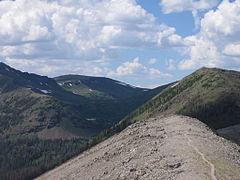 Looking north on the Continental Divide Trail between the Palisade Meadows cutoff and the Knife Edge.
 -
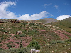 Abandoned mine shack near the Continental Divide Trail.
 -
 Grassy hills nearLemon Reservoir.


References
- ^ "Weminuche Wilderness". Geographic Names Information System. United States Geological Survey, United States Department of the Interior. Retrieved August 7, 2012.
- ^ "Weminuche Wilderness". San Juan National Forest. U.S. Forest Service. Retrieved 25 March 2021.
- ^ "Weminuche Wilderness: Rio Grande". Rio Grande National Forest. U.S. Forest Service. Retrieved 25 March 2021.
- ^ "Weminuche Wilderness". Wilderness.net. Wilderness Connect. Retrieved 25 March 2021.
- ^ ISBN 0898867843.
- ^ a b c Larson, Esper S. Jr.; Cross, Whitman (1956). Geology and Petrology of the San Juan Region, Southwestern Colorado. Professional Paper 258. Washington, D.C.: U.S. Geological Survey. Retrieved 24 March 2021.
- ^ a b c Larson, Esper S. Jr.; Cross, Whitman (1956). Geology and petrology of the San Juan region, southwestern Colorado: Map. Professional Paper 258. Washington, D.C.: U.S. Geological Survey. Retrieved 24 March 2021.
- ^ a b Barker, Fred (1956). Precambrian Geology of the Needle Mountains, Southwestern Colorado. Professional Paper 644-A. Washington, D.C.: U.S. Geological Survey. Retrieved 24 March 2021.
- ^ a b Gonzales, David A.; Conway, Clay M. (1994). "The Needle Mountains Proterozoic Complex: A Summary". Proterozoic Geology of the Western and Southeastern Needle Mountains, Colorado; Field Trip Guidebook. Open-File Report 94-437. Washington, D.C.: U.S. Geological Survey. pp. 31–50. Retrieved 24 March 2021.
- ^ Romero, Jonathan (17 January 2019). "As beetle kill spreads, will the drive from Durango to Silverton resemble Wolf Creek Pass?". durangoherald.com. The Durango Herald. Archived from the original on 4 February 2019. Retrieved 27 March 2021.
- ^ Romero, Jonathan (19 February 2021). "Beetle kill marches west across San Juan Mountains". durangoherald.com. The Durango Herald. Archived from the original on 16 March 2021. Retrieved 27 March 2021.
- ^ Mitten, Jeff (6 December 2019). "Introduced mountain goats have colonized much of the land above the trees". colorado.edu. Colorado Arts and Science Magazine. Archived from the original on 27 March 2021. Retrieved 27 March 2021.
- ^ "Non-native Species". nps.gov. Rocky Mountain National Park. 11 April 2019. Archived from the original on 11 November 2020. Retrieved 27 March 2021.
- ^ "Mountain Goat Management Plan EA". nps.gov. Grand Teton National Park. 19 March 2021. Archived from the original on 19 March 2021. Retrieved 27 March 2021.
- ^ "Mountain Goat Management Plan / EIS". nps.gov. Olympic National Park. Archived from the original on 20 August 2020. Retrieved 27 March 2021.
- ^ ISBN 978-1-56579-516-7.
- ^ a b c Trailhead and trail information is available at Colorado Trail Explorer. This includes information on the Needle Creek Trail and the Continental Divide Trail. Off-trail distances can also be computed. Accessed 28 March 2021
- ^ "Trip Planning Information: Weminuche Wilderness" (PDF). U. S. Forest Service. Retrieved 28 March 2021.
- ^ "Chicago Basin". San Juan Mountains Association. Retrieved 28 March 2021.
- ^ "CDT Weminuche Traverse Map". Caltopo.com. Retrieved 1 April 2021.
- ^ "CDT Weminuche Traverse Profile". Caltopo.com. Retrieved 1 April 2021.
- ^ ISBN 978-1-60732-837-7.