
Olympic National Park
| Olympic National Park | |
|---|---|
 Cedar Creek and Abbey Island from Ruby Beach | |
 Location in Washington  Location in the United States | |
| Location | Jefferson, Clallam, Mason, and Grays Harbor counties, Washington, United States |
| Nearest city | Port Angeles |
| Coordinates | 47°58′10″N 123°29′55″W / 47.96935°N 123.49856°W |
| Area | 922,650 acres (3,733.8 km2)[1] |
| Established | June 29, 1938 |
| Visitors | 2,432,972 (in 2022)[2] |
| Governing body | National Park Service |
| Website | Olympic National Park |
| Criteria | Natural: vii, ix |
| Reference | 151 |
| Inscription | 1981 (5th Session) |
Olympic National Park is a United States
President
Park purpose
As stated in the foundation document:[12]
The purpose of Olympic National Park is to preserve for the benefit, use, and enjoyment of the people, a large wilderness park containing the finest sample of primeval forest of Sitka spruce, western hemlock, Douglas fir, and western red cedar in the entire United States; to provide suitable winter range and permanent protection for the herds of native Roosevelt elk and other wildlife indigenous to the area; to conserve and render available to the people, for recreational use, this outstanding mountainous country, containing numerous glaciers and perpetual snow fields, and a portion of the surrounding verdant forests together with a narrow strip along the beautiful Washington coast.
Natural and geologic history
Coastline
The coastal portion of the park is a rugged, sandy beach along with a strip of adjacent forest. It is 60 miles (97 km) long but just a few miles wide, with native communities at the mouths of two rivers. The

The beach has unbroken stretches of wilderness ranging from 10 to 20 miles (16 to 32 km). While some beaches are primarily sand, others are covered with heavy rock and very large boulders. Bushy overgrowth, slippery footing, tides, and misty rainforest weather all hinder foot travel. The coastal strip is more readily accessible than the interior of the Olympics; due to the difficult terrain, very few backpackers venture beyond casual day-hiking distances.[14]
The most popular piece of the coastal strip is the 9-mile (14 km) Ozette Loop. The Park Service runs a registration and reservation program to control the usage levels of this area. From the trailhead at
There are thick groves of trees adjacent to the sand, which results in chunks of timber from fallen trees on the beach. The mostly unaltered Hoh River, toward the south end of the park, discharges large amounts of naturally eroded timber and other drift, which moves north, enriching the beaches. Even today driftwood deposits form a commanding presence, biologically as well as visually, giving a taste of the original condition of the beach viewable to some extent in early photos. Drift material often comes from a considerable distance; the Columbia River formerly contributed huge amounts to the Northwest Pacific coasts.
The smaller coastal portion of the park is separated from the larger, inland portion. President Franklin D. Roosevelt originally had supported connecting them with a continuous strip of parkland.

The park is known for its unique
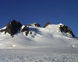
Glaciated mountains
Within the center of Olympic National Park rise the
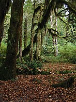
Temperate rainforest

The western side of the park is mantled by
As opposed to
Valleys on the eastern side of the park also have notable
Ecology

According to the A. W. Kuchler U.S. Potential natural vegetation Types, the park encompasses five classifications: Alpine Meadows & Barren, aka Alpine tundra (52) potential vegetation type with an Alpine Meadow (11) potential vegetation form; a Fir/Hemlock (4) vegetation type with a Pacific Northwest conifer forest (1) vegetation form; a cedar/hemlock/Douglas fir vegetation type with a Pacific Northwest conifer forest (1) vegetation form; Western spruce/fir vegetation type (15) with a Rocky Mountain conifer forest (3) vegetation form; and a spruce/cedar/hemlock (1) vegetation type with a Pacific Northwest conifer forest (1) vegetation form.[21]
Because the park sits on an isolated
The park also provides habitat for many species (like the
The park contains an estimated 366,000 acres (572 sq mi; 1,480 km2) of old-growth forests.[24]
Forest fires are infrequent in the rainforests of the park's western side; however, a severe drought after the driest spring in 100 years, coupled with an extremely low snowpack from the preceding winter, resulted in a rare rainforest fire in the summer of 2015.[25][26]
-
 The summit of Mount Olympus from the Blue Glacier
 -
 Subalpine fir in a meadow on Hurricane Ridge
 -
-
 Foggy sea stacks


Climate
According to the
| Climate data for Elwha Ranger Station, Washington, 1991–2020 normals, extremes 1942–2017 | |||||||||||||
|---|---|---|---|---|---|---|---|---|---|---|---|---|---|
| Month | Jan | Feb | Mar | Apr | May | Jun | Jul | Aug | Sep | Oct | Nov | Dec | Year |
| Record high °F (°C) | 64 (18) |
67 (19) |
70 (21) |
80 (27) |
87 (31) |
93 (34) |
96 (36) |
97 (36) |
91 (33) |
76 (24) |
70 (21) |
65 (18) |
97 (36) |
| Mean maximum °F (°C) | 51.1 (10.6) |
51.9 (11.1) |
60.1 (15.6) |
70.6 (21.4) |
77.8 (25.4) |
82.6 (28.1) |
87.6 (30.9) |
87.0 (30.6) |
79.5 (26.4) |
67.1 (19.5) |
55.4 (13.0) |
49.8 (9.9) |
90.7 (32.6) |
| Mean daily maximum °F (°C) | 41.1 (5.1) |
43.8 (6.6) |
49.7 (9.8) |
56.3 (13.5) |
63.4 (17.4) |
67.2 (19.6) |
73.6 (23.1) |
74.5 (23.6) |
68.1 (20.1) |
55.5 (13.1) |
45.6 (7.6) |
40.7 (4.8) |
56.6 (13.7) |
| Daily mean °F (°C) | 37.0 (2.8) |
38.3 (3.5) |
42.3 (5.7) |
47.1 (8.4) |
53.3 (11.8) |
57.2 (14.0) |
62.2 (16.8) |
63.0 (17.2) |
58.1 (14.5) |
48.5 (9.2) |
40.8 (4.9) |
36.7 (2.6) |
48.7 (9.3) |
| Mean daily minimum °F (°C) | 32.8 (0.4) |
32.8 (0.4) |
34.9 (1.6) |
37.8 (3.2) |
43.2 (6.2) |
47.2 (8.4) |
50.7 (10.4) |
51.6 (10.9) |
48.0 (8.9) |
41.5 (5.3) |
36.1 (2.3) |
32.7 (0.4) |
40.8 (4.9) |
| Mean minimum °F (°C) | 24.3 (−4.3) |
24.5 (−4.2) |
28.5 (−1.9) |
31.3 (−0.4) |
35.3 (1.8) |
40.4 (4.7) |
44.2 (6.8) |
44.9 (7.2) |
40.6 (4.8) |
32.6 (0.3) |
27.1 (−2.7) |
23.5 (−4.7) |
18.9 (−7.3) |
| Record low °F (°C) | 2 (−17) |
8 (−13) |
15 (−9) |
26 (−3) |
29 (−2) |
32 (0) |
31 (−1) |
36 (2) |
32 (0) |
21 (−6) |
10 (−12) |
8 (−13) |
2 (−17) |
| Average precipitation inches (mm) | 8.87 (225) |
6.14 (156) |
6.94 (176) |
3.28 (83) |
1.91 (49) |
1.39 (35) |
0.74 (19) |
1.14 (29) |
1.63 (41) |
5.85 (149) |
10.06 (256) |
9.92 (252) |
57.87 (1,470) |
| Average snowfall inches (cm) | 1.0 (2.5) |
0.5 (1.3) |
0.2 (0.51) |
0.0 (0.0) |
0.0 (0.0) |
0.0 (0.0) |
0.0 (0.0) |
0.0 (0.0) |
0.0 (0.0) |
0.0 (0.0) |
0.2 (0.51) |
0.1 (0.25) |
2.0 (5.1) |
| Average precipitation days (≥ 0.01 in) | 17.8 | 15.4 | 18.2 | 13.8 | 11.5 | 9.5 | 4.9 | 4.8 | 8.0 | 15.0 | 18.6 | 18.4 | 155.9 |
| Average snowy days (≥ 0.1 in) | 0.4 | 0.2 | 0.1 | 0.0 | 0.0 | 0.0 | 0.0 | 0.0 | 0.0 | 0.0 | 0.2 | 0.5 | 1.4 |
| Source 1: NOAA[30] | |||||||||||||
| Source 2: XMACIS[31] | |||||||||||||
| Climate data for Hoh Rainforest Visitor Center (elevation: 745 ft / 227 m), 1981–2010 | |||||||||||||
|---|---|---|---|---|---|---|---|---|---|---|---|---|---|
| Month | Jan | Feb | Mar | Apr | May | Jun | Jul | Aug | Sep | Oct | Nov | Dec | Year |
| Mean daily maximum °F (°C) | 44.7 (7.1) |
47.9 (8.8) |
51.4 (10.8) |
55.8 (13.2) |
61.8 (16.6) |
65.4 (18.6) |
70.8 (21.6) |
72.2 (22.3) |
67.4 (19.7) |
58.8 (14.9) |
48.9 (9.4) |
43.9 (6.6) |
57.5 (14.2) |
| Daily mean °F (°C) | 39.8 (4.3) |
41.2 (5.1) |
43.5 (6.4) |
46.8 (8.2) |
52.1 (11.2) |
56.1 (13.4) |
60.5 (15.8) |
61.3 (16.3) |
57.5 (14.2) |
50.8 (10.4) |
43.2 (6.2) |
38.8 (3.8) |
49.3 (9.6) |
| Mean daily minimum °F (°C) | 34.8 (1.6) |
34.4 (1.3) |
35.6 (2.0) |
37.8 (3.2) |
42.4 (5.8) |
46.8 (8.2) |
50.1 (10.1) |
50.5 (10.3) |
47.6 (8.7) |
42.7 (5.9) |
37.6 (3.1) |
33.8 (1.0) |
41.2 (5.1) |
| Average precipitation inches (mm) | 20.59 (523) |
14.45 (367) |
14.78 (375) |
10.60 (269) |
6.39 (162) |
4.68 (119) |
2.16 (55) |
2.76 (70) |
4.15 (105) |
13.11 (333) |
22.55 (573) |
19.07 (484) |
135.29 (3,436) |
| Average relative humidity (%)
|
85.1 | 76.0 | 76.8 | 74.1 | 71.9 | 73.9 | 68.8 | 69.9 | 69.0 | 74.2 | 83.0 | 83.1 | 75.5 |
| Average dew point °F (°C) | 35.7 (2.1) |
34.2 (1.2) |
36.7 (2.6) |
39.0 (3.9) |
43.3 (6.3) |
47.9 (8.8) |
50.2 (10.1) |
51.4 (10.8) |
47.4 (8.6) |
42.9 (6.1) |
38.4 (3.6) |
34.1 (1.2) |
41.8 (5.4) |
| Source: PRISM Climate Group[32] | |||||||||||||
Human history

Before the influx of European settlers, Olympic's human population consisted of Native Americans, whose use of the peninsula was thought to have consisted mainly of fishing and hunting. However, recent reviews of the record,[citation needed] coupled with systematic archaeological surveys of the mountains (Olympic and other Northwest ranges) are pointing to much more extensive tribal use of especially the subalpine meadows than seemed formerly to be the case. Most if not all Pacific Northwest indigenous cultures were adversely affected by European diseases (often decimated) and other factors, well before ethnographers, business operations and settlers arrived in the region, so what they saw and recorded was a much-reduced native culture base. Large numbers of cultural sites are now identified in the Olympic mountains, and important artifacts have been found.
When settlers began to appear, extractive industry in the
The formal record of a proposal for a new national park on the Olympic Peninsula begins with the expeditions of well-known figures Lieutenant Joseph P. O'Neil and Judge James Wickersham, during the 1890s. These notables met in the Olympic wilderness while exploring, and subsequently combined their political efforts to have the area placed within some protected status. On February 22, 1897, President Grover Cleveland created the Olympic Forest Reserve, which became Olympic National Forest in 1907.[33] Following unsuccessful efforts in the Washington State Legislature to further protect the area in the early 1900s, President Theodore Roosevelt created Mount Olympus National Monument in 1909, primarily to protect the subalpine calving grounds and summer range of the Roosevelt elk herds native to the Olympics.
Public desire for preservation of some of the area grew until President Franklin D. Roosevelt signed a bill creating a national park in 1938. The Civilian Conservation Corps constructed a headquarters in 1939 with funds from the Public Works Administration. It is now on the National Register of Historic Places.[34] The national park was expanded by 47,753 acres (19,325 ha) in 1953 to include the Pacific coastline between the Queets and Hoh rivers, as well as portions of the Queets and Bogachiel valleys.[35]
Even after ONP was declared a park, though,
Fauna

Animals that inhabit this national park include chipmunks, squirrels, skunks, six species of bats, weasels, coyotes, muskrats, fishers, river otters, beavers, red foxes, mountain goats, martens, bobcats, black bears, Canadian lynxes, moles, snowshoe hares, shrews, and cougars. Whales, dolphins, sea lions, seals, and sea otters swim near this park offshore. Birds that fly in this park including raptors are Winter wrens, Canada jays, Hammond's flycatchers, Wilson's warblers, Blue Grouses, Pine siskins, ravens, spotted owls, Red-breasted nuthatches, Golden-crowned kinglets, Chestnut-backed chickadees, Swainson's thrushes, Red crossbills, Hermit thrushes, Olive-sided flycatchers, bald eagles, Western tanagers, Northern pygmy owls, Townsend's warblers, Townsend's solitaires, Vaux's swifts, band-tailed pigeons, and evening grosbeaks.
Recreation

There are several roads in the park, but none penetrate far into the interior. The park features a network of hiking trails, although the size and remoteness mean that it will usually take more than a weekend to get to the high country in the interior. The sights of the rain forest, with plants run riot and dozens of hues of green, are well worth the possibility of rain sometime during the trip, although July, August, and September frequently have long dry spells.

An unusual feature of ONP is the opportunity for backpacking along the beach. The length of the coastline in the park is sufficient for multi-day trips, with the entire day spent walking along the beach. Although idyllic compared to toiling up a mountainside (Seven Lakes Basin is a notable example), one must be aware of the tide; at the narrowest parts of the beaches, the high tide washes up to the cliffs behind, blocking passage. Several promontories must be struggled over, using a combination of muddy steep trails and fixed ropes.
During winter, the viewpoint known as
Rafting is available on both the Elwha and Hoh Rivers. Boating is common on Ozette Lake, Lake Crescent, and Lake Quinault.[38] Fishing is allowed in the Ozette River, Queets River (below Tshletshy Creek), Hoh River, Quinault River (below North Shore Quinault River Bridge), Quillayute River and Dickey River.[38] A fishing license is not required to fish in the park. Fishing for bull trout and Dolly Varden trout is not allowed and must be released if incidentally caught.[39]

Views of the Olympic National Park can be seen from the Hurricane Ridge viewpoint. The road leading west from the Hurricane Ridge visitor center has several picnic areas and trailheads. A paved trail called the Hurricane Hill trail is about 1.6 miles (2.6 km) long each way, with an elevation gain of about 700 feet (210 m). It is not uncommon to find snow on the trails even as late as July. Several other dirt trails of varying distances and difficulty levels branch off of the Hurricane hill trail. The picnic areas are open only in the summer and have restrooms, water, and paved access to picnic tables.
The Hurricane Ridge visitor center burned down on May 7, 2023. Constructed in the 1950s, it contained a 3D topographical map of the Olympics, a media center which showed nature documentaries of the area as well as other interpretive exhibits, and a gift shop.[40] There is currently no timeline for when the center will be replaced; the project to rebuild the lodge and establish a temporary visitors' center was allocated $80 million in federal funding in late 2023.[41]

Elwha Ecosystem Restoration Project
The
See also
- Madison Creek Falls
- La Push Beach
- Ruby Beach
- Rialto Beach
- Sol Duc River
- National Register of Historic Places listings in Olympic National Park
- List of national parks of the United States
References
- ^ "Listing of acreage – December 31, 2011" (XLSX). Land Resource Division, National Park Service. Retrieved March 7, 2013. (National Park Service Acreage Reports)
- ^ "Annual Park Ranking Report for Recreation Visits in: 2022". nps.gov. National Park Service. Retrieved July 23, 2023.
- ^ Olympic National Park. "Directions and Transportation". National Park Service. Retrieved January 11, 2023.
- ^ "The Economy of the Olympic Peninsula and Potential Impacts of the Draft Congressional Watershed Conservation Proposal" (PDF). Bozeman: Headwaters Economics. March 2012. p. 6. Retrieved January 11, 2023.
- ISBN 9781426208690.
- ^ Olympic National Park. "Park Newsletter July/August 2009". National Park Service. Retrieved July 8, 2011.
- ^ "Proclamations and Orders Volume 2". National Park Service. Appendix III - National Park Service.
- ^ "The National Parks: Index 2009–2011". National Park Service. Retrieved January 11, 2023.
- ^ "Daniel J. Evans Wilderness". Wilderness Connect. Retrieved January 11, 2023.
- ^ a b Landers, Rich (December 7, 2016). "Olympic Wilderness re-named for Sen. Dan Evans". The Spokesman-Review. Retrieved August 18, 2017.
- ^ Ollikainen, Rob (August 18, 2017). "Ceremony marks change of name to Daniel J. Evans Wilderness". Peninsula Daily News. Retrieved August 18, 2017.
- ^ "Foundation Document Overview: Olympic National Park, Washington" (PDF). National Park Service History eLibrary. National Park Service. Retrieved January 11, 2023.
- ^ Olympic National Park. "Coast". National Park Service. Retrieved August 23, 2009.
- ^ "The best hikes in Olympic National Park offer sea stacks, waterfalls and ancient petroglyphs". Lonely Planet. October 14, 2021. Retrieved January 11, 2023.
- ^ Olympic National Park. "Ozette Loop". National Park Service. Retrieved January 11, 2023.
- ^ Olympic National Park. "Lake Ozette Area Brochure". National Park Service. Retrieved January 11, 2023.
- ^ Olympic National Park. "Weather Brochure". National Park Service. Retrieved January 11, 2023.
- ^ "11 Things You Didn't Know About Olympic National Park". U.S. Department of the Interior Blog. June 28, 2018. Retrieved January 11, 2023.
- ^ Wolford, Brooke (January 6, 2021). "Rainforest in Washington is the wettest in the continental US, officials say". The Olympian. McClatchy.
- ^ "Weather". Sequim Tourism, WA. Sequim, WA. Retrieved January 11, 2023.
- ^ Kuchler, A. W. "U.S. Potential Natural Vegetation, Original Kuchler Types, v2.0 (Spatially Adjusted to Correct Geometric Distortions)". Uploaded by Conservation Biology Institute. Retrieved July 15, 2019 – via Data Basin.
- ^ Blair, Seabury Jr. (May 17, 1992). "cougar warning". Kitsap Sun. Retrieved January 8, 2014.
- ^ "Mountain Goats in Olympic National Park: Biology and Management of an Introduced Species". National Park Service. Retrieved January 8, 2014.
- OCLC 31933118.
- ^ "Paradise Fire". InciWeb. 2015. Archived from the original on October 22, 2017.
- ^ Olympic National Park. "Current Fire Status". National Park Service. Paradise Fire (2015). Retrieved January 12, 2023.
- ^ "World Maps of Köppen-Geiger climate classification". Climate Change & Infectious Diseases Group.
- Britannica.com. Retrieved January 12, 2023.
- ^ "USDA Plant Hardiness Zone Map". Agricultural Research Service. USDA. View Maps. Retrieved January 13, 2023.
- ^ "U.S. Climate Normals Quick Access – Station: Elwha RS, WA". National Oceanic and Atmospheric Administration. Retrieved December 10, 2022.
- ^ "xmACIS2". National Oceanic and Atmospheric Administration. Retrieved February 15, 2023.
- ^ "PRISM Climate Group, Oregon State University". www.prism.oregonstate.edu. Retrieved July 15, 2019.
- ^ Olympic National Park. "Timeline of Human History". National Park Service. Retrieved January 13, 2023.
- ^ "Olympic National Park Headquarters - Port Angeles WA". Living New Deal. Retrieved August 6, 2021.
- ^ Setzer, Christopher (July 16, 2019). "Olympic National Park". HistoryLink. Retrieved November 26, 2021.
- ISBN 9781594858949.
- ^ Scruggs, Gregory (December 31, 2022). "Wild Olympics wilderness expansion proposal falls short in Congress". The Seattle Times. Retrieved March 3, 2024.
- ^ a b Olympic National Park. "Boating". National Park Service. Retrieved December 7, 2022.
- ^ Olympic National Park. "Fishing". National Park Service. Retrieved November 6, 2021.
- ^ "Hurricane Ridge". National Park Service.
- ^ Scruggs, Gregory (October 27, 2023). "Murray earmarks $80M to rebuild Hurricane Ridge Day Lodge". The Seattle Times. Retrieved March 3, 2024.
- ^ Coastal and Marine Hazards and Resources Program (June 17, 2019). "Elwha River Restoration Project". U.S. Geological Survey. Retrieved March 4, 2022.
External links
 Media from Commons
 Travel information from Wikivoyage
- Official website
- Historic American Engineering Record (HAER) No. WA-166, "Olympic National Park Road System, Port Angeles, Clallam County, WA", 46 photos, 39 data pages, 4 photo caption pages
- "The Pacific Northwest: Olympic Peninsula Community Museum". University of Washington.
- "The Evergreen Playground". Olympic Peninsula Community Museum. University of Washington.
- Kirk, Ruth. "Olympic National Park". Full Focus. KBTC Public Television. Archived from the original on July 2, 2011.
- Kirk, Ruth (November 3, 2009). Full Focus: Olympic National Park. PBS.
- "Hurricane Ridge". National Park Service.