
Windsor, New South Wales
| Windsor Federal division(s) | Macquarie | ||||||||||||||
|---|---|---|---|---|---|---|---|---|---|---|---|---|---|---|---|
| |||||||||||||||
Windsor is a historic town in north-west of
Demographics


At the 2016 census, Windsor had a reported population of 1,891 people, with a median age of 42. The most common ancestries in Windsor were English (30.9%), Australian (28.9%), Irish (10.3%), Scottish (7.5%), and German (2.8%). Most people from Windsor were born in Australia (78.8%), followed by England (3.3%), and New Zealand (1.5%).[1]
The most common religious group in Windsor was Christianity (65.8%), 25.2% being Catholic and 23.0% Anglican. The second largest group was No Religion (28.9%).[1]
The most common occupations in Windsor included Professionals (15.9%), Technicians and Trades Workers (15.1%), Clerical and Administrative Workers (13.6%), Managers (12.8%), and Labourers (11.0%). The median weekly household income was A$1,422.[1]
Geography
Greater Windsor area include South Windsor, Bligh Park, Windsor Downs, McGraths Hill and Mulgrave suburbs. People from Colo, Wilberforce, Ebenzeer, Freemans Reach, Glossodia and Pitt Town also comes to Windsor for shopping and day to day needs.
Windsor's proximity to the Hawkesbury River has resulted in numerous disastrous floods. A horseshoe on the outside wall of the Macquarie Arms pub marks the level the flood peaked at in 1867. During the 1867 flood, beaches along the Hawkesbury River to Barrenjoey were littered with the debris from the town.
History
The Windsor area was originally inhabited by the
Windsor is the fourth oldest place of
While in Windsor,
Windsor was chosen during settlement because of its agricultural potential and accessible location. In 1813 a report was given to Governor Macquarie from Earl Bathurst detailing a proposed invasion of the Hawkesbury River by France.[4] This planned invasion that did not eventuate targeted the Windsor granary in order to cut off supply to Sydney, demonstrating the relative importance of this new settlement on a global scale. Windsor is 56 km (35 mi) north-west of Sydney, and easily accessible by coastal shipping from Sydney along the Hawkesbury River. It was known as the "bread basket", ensuring the survival of the starving colony. The extensive agriculture caused major silting in the Hawkesbury River; by the 1890s the Hawkesbury River had become so blocked with silt, ships could not travel up to Windsor from the coast. By then, a railway (in 1864) and road (in 1814) had been built to compensate.
On 1 January 1803,


.jpg)
Attractions and Heritage listings
Major attractions of Windsor are The Windsor Mall (Water Wheel), Windsor Mall Sunday Market, Hawkesbury Regional Museum, Howe Park, Windsor Beach, Macquarie Park, Governor Philip Park, Hawkesbury Regional Gallery, St Matthew's Anglican Church, Windsor Bridge and Hawkesbury Paddlewheeler.
Windsor has a number of heritage-listed sites, including:
|
|
Media
The studios of local community radio station, Hawkesbury Radio, are located in Windsor.
Transport
Urban sprawl of metropolitan Sydney has almost reached Windsor. The town is now regarded as an outer suburb which has retained its appeal as a small country town. Growth in the Hawkesbury area has created an increased need for public transport and roads. Most people from Windsor traveled to work by car in 2016 (68.9%).[1] Only 9.0% of people used public transport.[1]
Windsor railway station opened 1 December 1864.[29] It is on the Richmond branch.
Located in the town centre is the
The new bridge has a centreline height of 17.8 metres Australian Height Datum (AHD) (ie significantly higher than the typical water level – peak flood levels at Windsor bridge are 11.1 metres AHD and 17.2 metres AHD for the five year and 100 year ARI events respectively.[33]). In 2021 the bridge was closed due to flooding in March 2021,[34] and further work on the new bridge was completed[35]
Windsor is also connected to Parramatta via the 31-kilometre-long (19 mi) Windsor Road cycleway, with much of its route via the North-West T-way.[36]
Commercial area
The Windsor Mall Sunday Market are held weekly on Sunday between 9.00am to 3.00pm. The markets contain stalls selling jewellery, books, arts and crafts, paintings, fashion items, fresh locally grown produce, locally produced jams and many food and drink stands.
Gallery
-
 Historic Home in Windsor
 -
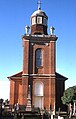 St Matthew's Anglican Church, designed by Francis Greenway
 -
 Interior of St Matthew's Church
 -
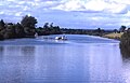 Hawkesbury River at Windsor
 -
 Poster Contest (Royal Australian Historical Society)


.jpg)
Bibliography
- Bowd, D. G. Macquarie Country: A History of the Hawkesbury. Library of Australian History, 1994.
- CAWB. ‘Windsor Bridge.’ http://www.cawb.com.au/the-place.html
- Fitzpatrick, J.C.L. When We Were Boys Together: reminiscences of the Hawkesbury district. C. McHardy, c2004.
- Jack, Ian, and Jan Barkley-Jack. St Matthews Windsor - An Anglican Landmark celebrating 200 years. Rosenberg Publishing, 2016.
- Proudfoot, Helen. The Hawkesbury: A Thematic History. Hawkesbury City Council, 2017. https://www.hawkesbury.nsw.gov.au/__data/assets/pdf_file/0004/119911/The-Hawkesbury-A-Thematic-History-2017-February.pdf
- Smith, Heather. Leaving The Barracks - Windsor Police Station, 1862 – 2010. H. Smith, 2011.
- Steele, James. Early Days of Windsor. https://gutenberg.net.au/ebooks13/1302241h.html
See also
- Dillwynia Women's Correctional Centre
- John Morony Correctional Centre
- Windsor Wolves
- Richmond, New South Wales
References
- ^ a b c d e f Australian Bureau of Statistics (27 June 2017). "Windsor (State Suburb)". 2016 Census QuickStats. Retrieved 14 October 2018.
- ^ Windsor Postcode Archived 14 February 2022 at the Wayback Machine Australia Post
- ^ Baker, Helen (1967). Historic Buildings. Windsor and Richmond (1st ed.). The State Planning Authority of New South Wales.
- ^ "Reports of a possible French invasion off the Hawksbury". Hawkesbury Historical Society. Archived from the original on 19 March 2012. Retrieved 18 December 2016.
- .
- .
- .
- .
- .
- .
- .
- .
- .
- .
- .
- .
- .
- .
- .
- .
- .
- .
- .
- .
- .
- .
- .
- .
- ^ Station Names. Date of opening, closing and/or change of name. Public Transport Commission of New South Wales. Administrative Branch (Archives Section) (3rd ed.). February 1979 [1965]. p. 37.
{{cite book}}: CS1 maint: others (link) - ^ Liz Foschia (4 December 2013). "NSW Premier's office accused of political interference in Windsor Bridge approval". ABC News. Australia. Archived from the original on 31 October 2016. Retrieved 15 January 2015.
- ^ CAWB. "An Alternative – CAWB". Community Action for Windsor Bridge. Archived from the original on 20 December 2016. Retrieved 6 December 2016.
- ^ Windsor Bridge replacement Archived 18 April 2020 at the Wayback Machine Transport for NSW
- ^ "Windsor Bridge EIS - Chapter 7.7 - Hydrology" (PDF). Roads-waterwasys.transport.nsw.gov.au. November 2012. Archived (PDF) from the original on 8 March 2022. Retrieved 1 February 2022.
- ^ "The New Windsor Bridge has re-opened after flooding forced its closure". Facebook.com. Archived from the original on 1 February 2022. Retrieved 1 February 2022.
- ^ "Windsor Bridge replacement". Roads-waterways.transport.nsw.gov.au. 30 January 2023. Archived from the original on 24 November 2021. Retrieved 24 November 2021.
- ^ 83 Macquarie St, Parramatta NSW 2150 to 98 Macquarie St, Windsor NSW 2756 (Map). Google Maps. Retrieved 18 December 2016.
External links
| International | |
|---|---|
| National | |
| Geographic | |