
Zennor Head
| Zennor Head | |
|---|---|
National Trust |
Zennor Head
Etymology
The name "Zennor Head" originates from the name of a local saint, Senara. According to local legend, Senara was thrown off a headland in Brittany in a barrel after being falsely accused of adultery by her husband and washed up on the Cornish coast, founding Zennor and giving her name to the eponymous village (and subsequently Zennor Head, Zennor Quoit and Porthzennor Cove), before continuing to Ireland.[1][2] The "s" changed to a "z", an occurrence common in the West Country but rare elsewhere, and as such is the largest coastal feature in the United Kingdom to begin with the letter "Z".[1]
History

The headland is bordered by Cornish granite hedges, and the farming system dates from about 4000 BC, the time of the Bronze Age in Cornwall.[2] The surrounding area and village of Zennor has been continually occupied for over 4,000 years.[3] Zennor Head was mined extensively for copper and tin in the 19th century, and drainage adits remain visible on the eastern side.[3]
The promontory was donated to the
Geography and geology
Zennor Head is located on the north coast of Cornwall, England, facing the Atlantic Ocean. A headland extending some 750 metres (2,460 ft), it is surrounded by steep cliffs plunging into the sea below. It is west of the town of St Ives, and north-east of the town of Penzance. The nearest human settlement is the village of Zennor, and the headland is flanked by two coves, Pendour and Porthzennor. The nearest headland is Gurnard's Head, 1.6 kilometres to the west.[1][10] Access is from the South West Coast Path, or the B3306 road (West Cornwall coast road).[3] There is a deep inlet known as Horseback Zawn on the western side, where seabirds nest.[3] The headland is topped by an Ordnance Survey "Trig Point".[11] The Killas strata, which is exposed over the majority of Zennor Head, is a
Fauna and Flora

Zennor Head is home to a variety of wildlife, including the
The headland is primarily covered with grass, as well as
Gallery
-
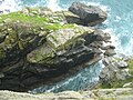
 Perched rock at the foot of Zennor Head
 -
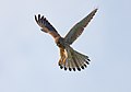 Common kestrel
 -
 Eastern flank
 -
 Thrift, a coastal plant
 -
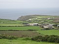 Zennor Head from inland
 -
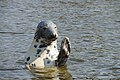 Grey seal
 -
 Horseback Zawn


References
- ^ ISBN 978-1-84046-754-3
- ^ a b "About Zennor". Zennor Parish Council. Archived from the original on 22 April 2009. Retrieved 17 February 2012.
- ^ a b c d e f g h i j k l Zennor Head Walk – National Trust[permanent dead link], retrieved 30 October 2012
- The National Trust. 1953.
- ^ "Walk - Zennor". South West Coast Path. Retrieved 2 January 2013.
- ^ "The Coastal Footpath". Homepage.ntlworld.com. Archived from the original on 25 April 2012. Retrieved 25 February 2012.
- ^ Champion, Jim (15 August 2009). "Coast path temporarily closed near Zennor Head". Geograph. Retrieved 31 October 2012.
- ^ "Penwith Heritage Coast". Britain Express. Retrieved 17 February 2012.
- ^ Map of Zennor (PDF) (Map). Zennor Village: Zennor Parish Council. Retrieved 1 January 2013.[permanent dead link]
- ^ Walking in Britain; by David Else, Sandra Bardwell, Belinda Dixon, Peter Dragicevich. Lonely Planet
- ISBN 978-0-319-23148-7
- ^ Cornwall Wildlife Trust (2012). "Killas". Cornish Geology. Archived from the original on 14 January 2011. Retrieved 25 February 2012.
- ISBN 0-521-78673-8.
- ^ G. A. Steven (1934). A Short Investigation into the Habits, Abundance, and Species of Seals on the North Cornwall Coast. Journal of the Marine Biological Association of the United Kingdom (New Series), 19, pp 189–501 doi:10.1017/S0025315400046580
- ^ West Penwith, Penzance & Land's End accessed 4 March 2012
- ^ Coombe, D. E., & Morisset, P. (1967). Further observations on Trifolium occidentale. Watsonia, 6, 271–275.
- ^ Sparrius, L. B., James, P. W., & Allen, M. A. (2005). The sorediate variety of Sclerophytomyces circumscriptus. The Lichenologist, 37(4), 285–290.
- ISBN 978 0953461301.