
Pentire Head
Pentire Head | |
|---|---|
 View of Pentire Point taken from Polzeath | |
 Location in Cornwall | |
| Coordinates: 50°35′02″N 4°55′08″W / 50.584°N 4.919°W | |
| Grid position | SW934802 |
| Location | Cornwall |
Pentire Head (Cornish: Penn Tir, meaning "headland")[1] is a headland and peninsula on the Atlantic coast in North Cornwall, England, and is about one mile square. The headland projects north-west with Pentire Point at its north-west corner and The Rumps promontory at its north-east corner.[2]
Etymology
The origin of the name is from Cornish penn (head) and tir (land): another headland with the name Pentire is further west near Crantock.
Geography

Pentire Point and
The entire headland forms the Pentire Peninsula
A small island named Newland, but sometimes referred to as Puffin Island[
The South West Coast Path closely follows the coastline of the headland, and sightseeing boat tours regularly travel along the coast from the nearby port of Padstow.
History
On The Rumps is an Iron Age cliff castle dating back to the second century BC. The site was first recorded in 1584 when it was referred to as Pentire Forte, and was excavated by the Cornwall Archaeological Society between 1963 and 1967.[15] Today the fort itself can be identified by the three ramparts crossing the narrower strip of land linking the Rumps headland to the main part of Pentire Head. It is thought that the various ramparts have different dates and may have exploited existing features in their construction,[16] while excavation indicates that there were three phases of building and two phases of occupation with hut platforms and domestic debris having been found along with evidence of a pallisade and a timber gate.[15] The castle is listed on the English Heritage at risk register as it is in danger of being lost to erosion. The state of the site was described as declining in 2019.[17][18]
"For The Fallen"

The poet Laurence Binyon wrote "For the Fallen" (first published in The Times in September 1914) while sitting by the cliffs between Pentire Point and The Rumps. A stone plaque was erected in 2001 to commemorate the fact and bears the inscription
FOR THE FALLEN
Composed on these cliffs 1914
The plaque also bears the fourth stanza of the poem:
They shall grow not old, as we that are left grow old
Age shall not weary them, nor the years condemn
At the going down of the sun and in the morning
We will remember them
Gallery of images
-
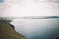 The view from Pentire Point, looking towards Polzeath and Trebetherick Point.
 -
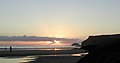
 Another view of Polzeath from Pentire Point.
 -
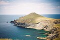
 Pentire Point and Puffin island.
 -
 Puffin island and Pentire Point at sunset.
 -
 Puffin island seen from Pentire Point.
 -
 The Rumps, site of Iron Age cliff fortifications.
 -
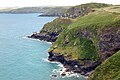 Looking across Port Quin Bay from the east side of Pentire Head.


See also
- They Shall Not Grow Old (2018 documentary film)
References
- ^ Place-names in the Standard Written Form (SWF) Archived 2013-05-15 at the Wayback Machine : List of place-names agreed by the MAGA Signage Panel Archived 2013-05-15 at the Wayback Machine. Cornish Language Partnership.
- ISBN 978-0-319-22938-5
- ^ "Pentire Peninsula" (PDF). Natural England. 17 September 1986. Retrieved 25 October 2011.
- ^ Ferris, L. C. (1969). Pebbles on Cornwall's beaches. Tor Mark Press. p. 12.
- ^ Barton, R M. Cornwall's structure and scenery. Tor Mark Press. p. 37.
- ^ Ferris, L. C. (1969). Pebbles on Cornwall's beaches. Tor Mark Press. p. 37.
- ^ "Pentire Cliffs, Polzeath, St Minver, Cornwall, England, UK". Mindat.org. Retrieved 28 March 2020.
- ^ a b "Pentire Mine, Polzeath, St Minver, Wadebridge District, Cornwall, England, UK". Mindat.org. Retrieved 28 March 2020.
- ^ "The Rumps to Polzeath around Pentire Point". Walks in Cornwall with mining/quarrying heritage. iWalk Cornwall. Retrieved 28 November 2020.
- ISBN 0 9520627 0 4.
- ^ "Pentireglaze mines, Cornwall". www.cornwall-calling.co.uk. cornwall calling. Retrieved 28 March 2020.
- ^ "The Rumps to Polzeath around Pentire Point". iWalk Cornwall. Retrieved 28 November 2020.
- ^ "Pentireglaze Mine, Polzeath, St Minver, Wadebridge District, Cornwall, England, UK". Mindat.org. Retrieved 13 September 2022.
- ^ "Where to park around Polzeath and Port Quin". National Trust. Retrieved 28 March 2020.
- ^ a b "Promontory fort called The Rumps". AncientMonuments.uk. Retrieved 28 March 2020.
- ^ "Pentire". National Trust. Retrieved 28 March 2020.
- ^ "Heritage at Risk 2019". Historic England. 2019. Retrieved 15 October 2020.
- ^ "The Rumps promontory fort, St. Minver Highlands - Cornwall". Historic England. 2020. Retrieved 15 October 2020.
External links
 Media related to Pentire Head at Wikimedia Commons
- Pentire Point at Polzeath
| Unitary authorities | |
|---|---|
| Major settlements (cities in italics) |
|
| Rivers | |
| Topics | |