
Świętochłowice
Świętochłowice
Świyntochłowice (Silesian) | ||
|---|---|---|
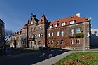
 Downtown | ||
|
Car plates SW | | |
| Primary airport | Katowice Airport | |
| Website | www | |
Świętochłowice (Polish:
It is situated in the
History
Initially, Świętochłowice was divided into two parts: the older Małe Świętochłowice (Little Świętochłowice) and newer Duże Świętochłowice (Big Świętochłowice), which date back to the 12th and 13th centuries, respectively.

In 1742 the settlement was annexed by
In early September 1939, during the German invasion of Poland which started World War II, Świętochłowice was the site of Polish defense, also by the civilian population. Already on September 3–4, 1939, Wehrmacht and Freikorps troops murdered 10 Poles in Świętochłowice (see Nazi crimes against the Polish nation).[5] Afterwards, the town was occupied by Germany. In 1943, the Germans established the Eintrachthütte concentration camp, a forced labour subcamp of the Auschwitz concentration camp.[6] In early 1945 it was occupied by the Soviets, who established the Zgoda labour camp.
After the war, Świętochłowice once again restored to Poland. In 1951 its city limits were extended with Chropaczów and Lipiny becoming new districts.[3]
Location

Świętochłowice is situated in the middle of a highly populated area of Upper Silesia and is part of the Metropolis GZM, the largest urban center in Poland and one of the largest in Europe.
Places adjacent to Świętochłowice | ||||||||||||||||
|---|---|---|---|---|---|---|---|---|---|---|---|---|---|---|---|---|
| ||||||||||||||||
Population
Currently (2013) Świętochłowice has about 53,000 inhabitants and is thus the city county with the highest population density in Poland. The population of the entire urban area is about 3.5 million.
Climate and soil
Świętochłowice is situated in Silesian-Krakowian climate-zone. The annual precipitation totals to about 700 mm (28 in). The wettest month is July and the driest February. The average temperature is approximately −2.5 °C (27 °F) in January and 18 °C (64 °F) in July.
Brunate and swamp soils predominate in Świętochłowice.
Districts

Świętochłowice has five administrative subdivisions:
Sights
The Silesian Uprisings Museum, devoted to the history of the Silesian Uprisings (1919–1921), is located in Świętochłowice. In addition, the city has historical industrial architecture, town halls, churches, tenement houses and familoks.
-
 Silesian Uprisings Museum
 -
 Town Hall
 -
 Church of St. John the Baptist
 -
 Former mine and steelwork headquarters


Sport
The most popular sport in Świętochłowice is motorcycle speedway. The Skałka Stadium is located in the Centrum.
Sport clubs
- Śląsk Świętochłowice – football, speedway
- Naprzód Lipiny – football
- Czarni Świętochłowice – football
Sportspeople of Świętochłowice in Olympic Games


- 1928 – Amsterdam
- football – Teodor Peterek
- gymnastics – Paweł Galus, Franiciszek Pampuch, Teofil Rost, Franciszek Tajstra
- 1936 – Berlin
- football – Hubert Gad, Ryszard Piec, Teodor Peterek
- gymnastics – Klara Sierońska-Kostrzewa
- 1952 – Helsinki
- football – Ewald Cebula
- swimming – Gotfryd Gremlowski
- 1956 – Melbourne
- gymnastics – Małgorzata Błaszczyk-Wasilewska
- 1960 – Rome
- football – Roman Lentner
- 1964 – Tokyo
- gymnastics – Gerda Bryłka-Krajciczek, Małgorzata Wilczek-Rogoń
- gymnastics –
- 1976 – Montreal
- fencing – Barbara Wysoczańska
- weightlifting – Leszek Skorupa
- 1976 – Innsbruck
- ice-hockey – Kordian Jajszczok
- 1980 – Moscow
- fencing – Barbara Wysoczańska
Politics
The President of Świętochłowice is Daniel Beger. He was elected in 2018.
Notable people
- Ewald Cebula (1917–2004), footballer
- Arthur Goldstein (1887–1943), German journalist and communist politician
- Krzysztof Hanke (born 1957), actor and satiris
- Salomon Morel (1919–2007), commandant of Zgoda labour camp
- Teodor Peterek (1910–1969), footballer
- Jacob Sonderling (1878–1964), German-American Rabbi
- Paweł Waloszek (1938–2018), motorcycle speedway rider
Twin towns – sister cities
Świętochłowice is twinned with:[7]
 Heiloo, Netherlands
 Laa an der Thaya, Austria
 Nový Jičín, Czech Republic
 Rimavská Sobota, Slovakia
 Tai'an, China
 Tiszaújváros, Hungary
- Torez, Ukraine
References
- ^ "Population. Size and structure and vital statistics in Poland by territorial division in 2019. As of 30th June". stat.gov.pl. Statistics Poland. 2019-10-15. Retrieved 2020-02-14.
- European Spatial Planning Observation Network (ESPON) "Project 1.4.3". Archived from the originalon 2009-07-28. Retrieved 2009-03-28.
- ^ a b c d e f g Iwona Szopa. "Jak powstały Świętochłowice?". UM Świętochłowice (in Polish). Retrieved 9 February 2020.
- ^ a b c Miejska strategia rozwiązywania problemów społecznych Świętochłowic na lata: 2006–2015, Świętochłowice 2005, p. 13 (in Polish)
- ^ Wardzyńska, Maria (2009). Był rok 1939. Operacja niemieckiej policji bezpieczeństwa w Polsce. Intelligenzaktion (in Polish). Warszawa: IPN. p. 135.
- ^ "Eintrachthütte". Memorial and Museum Auschwitz-Birkenau. Retrieved 8 May 2021.
- ^ "Miasta partnerskie". swietochlowice.pl (in Polish). Świętochłowice. Retrieved 2020-03-11.
External links
- Official web
- Jewish Community in Świętochłowice on Virtual Shtetl
- Świętochłowician discussion forum
| City counties |  | |
|---|---|---|
| Land counties | ||
| International | |
|---|---|
| National | |
| Geographic | |