
Aach, Baden-Württemberg
This article needs additional citations for verification. (July 2008) |
Aach | |
|---|---|
 | |
 Coat of arms | |
Location of Aach within Konstanz district 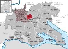 | |
 Aach  Aach | |
| Coordinates: 47°50′44″N 8°51′6″E / 47.84556°N 8.85167°E | |
| Country | Germany |
| State | Baden-Württemberg |
| Admin. region | Freiburg |
| District | Konstanz |
| Government | |
| • Mayor (2017–25) | Manfred Ossola[1] (CDU) |
| Area | |
| • Total | 10.69 km2 (4.13 sq mi) |
| Elevation | 545 m (1,788 ft) |
| Population (2022-12-31)[2] | |
| • Total | 2,384 |
| • Density | 220/km2 (580/sq mi) |
| Time zone | UTC+01:00 (CET) |
| • Summer (DST) | UTC+02:00 (CEST) |
| Postal codes | 78267 |
| Dialling codes | 07774 |
| Vehicle registration | KN |
| Website | www.aach.de |
Lordship of Aach Herrschaft Aach | |||||||||
|---|---|---|---|---|---|---|---|---|---|
| before 1100 – 1805 | |||||||||
| Status | Lordship | ||||||||
| Capital | Aach | ||||||||
| Common languages | Mediatised to Baden | 1805 | |||||||
| |||||||||
Aach (German pronunciation: [ˈaːx] ⓘ) is a small town in the German state of Baden-Württemberg (the region of Hegau). Being situated close to Lake Constance and the Swiss border, it is mostly known for the Aachtopf — Germany's biggest natural spring in terms of production. The town was originally twinned with the region of Colmnitz, but following the integration of Colmnitz into Klingenberg, Saxony the town is now twinned with Klingenberg itself.
History
Aach was first mentioned in the year 1100, as part of the
In 1499 battles of the Swabian War took place right before gates of Aach. Only 26 years later, in 1525, the German Peasants' War reached Aach, when region's aristocrats flew from the uprisings to the city, whereupon it was occupied by the rebel peasants. However, the uprisings were thrown down quickly by September 1525.
On March 25, 1799, there was a battle in Aach between Austria and France in the Napoleonic Wars. After Austria's defeat in the Third Coalition 1805, Aach came to the Kingdom of Württemberg (from 1810 the Grand Duchy of Baden), which joined the German Empire in 1871.
After World War II Aach became a part of the new (West) German state of Baden-Württemberg. Following district boundary redrawings in 1973, the city moved from the Stockach district to its current distract, Konstanz.
Jewish history
The first record of Jews in Aach is dated to 1518, in which the Jews of nearby Geisingen were accused of murdering a Christian child, an incident that can be considered a Blood libel. Every ten years, the local Jews were required to renew their residence permits. Between 1560 and 1570, five Jewish families resided in the town. Jews could host a maximum of five guests. They were required to notify the authorities upon the arrival of a Jewish visitor, and he could not trade with the local townspeople. In 1583, residence rights, now truncated to five-year increments, were renewed for Aach's six Jewish families. Additional restrictions were imposed on the town Jews, forbidding them to deal with agricultural products, and chant at the synagogue.[3]
Population change
| Year | Population | Change (%) | Year | Population | Change (%) | Year | Population | Change (%) | ||
|---|---|---|---|---|---|---|---|---|---|---|
| 1871 | 914 | n/a | 1950 | 1117 | +1.9 | 1990 | 1575 | +13.6 | ||
| 1880 | 954 | +4.4 | 1956 | 1274 | +14.1 | 1995 | 1973 | +25.3 | ||
| 1890 | 949 | -0.5 | 1961 | 1453 | +14.1 | 2000 | 2113 | +7.1 | ||
| 1900 | 972 | +2.4 | 1965 | 1427 | -1.8 | 2005 | 2230 | +5.5 | ||
| 1910 | 1011 | +4.0 | 1970 | 1355 | -5.0 | 2010 | 2175 | -2.5 | ||
| 1925 | 1014 | +0.3 | 1975 | 1415 | +4.4 | 2015 | 2243 | +3.1 | ||
| 1933 | 960 | -5.3 | 1980 | 1387 | -1.98 | 2020 | 2314 | +3.2 | ||
| 1939 | 1096 | +14.2 | 1987 | 1387 | = | 2025 | n/a | n/a | ||
| Source: Statistisches Landesamt Baden-Württemberg: Struktur- und Regionaldatenbank | ||||||||||
Geography
Aach is situated at the edge of the
The neighbouring settlements are Eigeltingen in the north, Orsingen-Nenzingen in the east, Volkertshausen in the south, and Mühlhausen-Ehingen in the west.
Land zoning
The following table shows the percentage of land in the town allocated for specific users, as of 31 December in the respective years.
| Zone | 1988 | 2000 | 2010 |
|---|---|---|---|
| Agricultural land | 50.7 % | 47.9% | 42.6 % |
| Forest | 40.4 % | 40.7 % | 41.8 % |
| Housing and transport | 7.9 % | 10.6 % | 13.2 % |
| Water | 0.7 % | 0.6 % | 1.1 % |
| Other | 0.3 % | 0.2 % | 1.3 % |
| Source: Statistisches Landesamt Baden-Württemberg: Struktur- und Regionaldatenbank | |||
Law and government
Aach has formed a cooperation with the nearby City of
Aach has a city council with ten seats. The last elections in 2017 brought five for the
| Party | Vote Share | Seats | 2014 Result | |
|---|---|---|---|---|
| CDU | 47.93 % | 5 | 40.5 %, 4 Seats | |
| Freie Wählervereinigung Aach | 41.23 % | 4 | 30.0 %, 3 Seats | |
| Unabhängige Freie Liste Aach | 10.84 % | 1 | – | |
| SPD | – | – | 23.8 %, 2 Seats | |
| FDP | – | – | 5.6 %, 1 Seat |
Coat of arms
Blazon: "In red a golden (yellow) lion with three silver (white) stars distributed between the paws."
Significance: The lion can be considered as an indication of the affiliation to Habsburg. The stars served to distinguish it from the coat of arms of the dominion.
Landmarks

Buildings
- The old town hall at Stadtstraße 38 was named as "monument of the month" for November 2008 by the Denkmalstiftung Baden-Württemberg.
- On the edge of the town lies the old ruins of the Tower of Aach, dating back to the 11th century.
Natural beauties
The Aachtopf, the strongest spring in Germany, is located in the town area of Aach. The Aachtopf is the source of the Radolfzeller Aach, which flows into Lake Constance. It is fed by the water of the Danube, which seeps northwards about twelve kilometres (as the crow flies) from the source of the Aach between Immendingen and Fridingen in the karstified limestone of the White Jurassic (Danube seepage) and emerges here with an average discharge of 8,300 L/s (minimum 1,300 L/s, maximum 24,100 L/s).
For more attractions in Aach, see the respective list on the German Wikipedia.
Economy and Infrastructure
Business
Various commercial enterprises are located in the town of Aach, most of them in an inter-municipal commercial area with the municipality of Volkertshausen.
Education
In Aach there is a public primary school with circa 100 pupils. The public secondary school was closed in summer 2010 after only 13 pupils attended this school in the last school year. There is also a kindergarten in Aach.
Transport
The nearest train station is five kilometres away in Mühlhausen-Ehingen. There are connections to long-distance trains from Singen, twelve kilometres away, or from the station in Engen, six kilometres away.
Bus connections go to Singen, Stockach and in the direction of Engen.
Aach is not far from the Hegau motorway junction. There are fast connections in all directions via the Bundesstraße 81, the Bundesstraße 98 and the two-lane Landesstraße 33. The town is also located on Landesstraße 31 (Freiburg im Breisgau-Friedrichshafen).
Personalities
- Otto Trippel (1891–1954), Documentary filmmaker
- Andreas Mettler (* 1968), Games designer and developer
- Thomas Rid (* 1975), Political Scientist and non-fiction author
References
- ^ Aktuelle Wahlergebnisse, Staatsanzeiger, accessed 13 September 2021.
- Statistisches Landesamt Baden-Württemberg. June 2023.
- ^ Richard Gottheil. "AACH". Jewish Encylocpedia. Retrieved 17 February 2020.
External links
- (in German) Aach:History and images
Towns and municipalities in Konstanz (district) | ||
|---|---|---|
 | ||
| International | |
|---|---|
| National | |
| Geographic | |