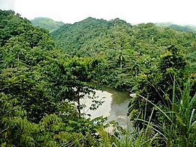
Alejandro de Humboldt National Park
This article needs additional citations for verification. (May 2011) |
| Alejandro de Humboldt National Park | |
|---|---|
 Alejandro de Humboldt National Park | |
| Location | Cuba |
| Nearest city | Guantánamo |
| Coordinates | 20°27′N 75°00′W / 20.450°N 75.000°W |
| Area | 711.38 km2 (274.67 sq mi)[1] |
| Type | Natural |
| Criteria | ix, x |
| Designated | 2001 (25th session) |
| Reference no. | 839rev |
| Region | Latin America and the Caribbean |
Alejandro de Humboldt National Park (
Geography
The rivers that flow off the peaks of the park are some of the largest in the insular Caribbean. The park is said to be the most humid place in Cuba[3] and this causes a high biological diversity. The park has an area of 711.38 km2 (274.67 sq mi),[1] of which 685.72 km2 (264.76 sq mi) land area and 22.63 km2 (8.74 sq mi) marine area. Elevation ranges from sea level to 1,168 m (3,832 ft) on El Toldo Peak.
The region around Alejandro de Humboldt National Park is geologically complex, containing
Wildlife
The area comprising the national park was a
Over 900 total plant species have been recorded at the park, along with 45 species of reptiles, 21 amphibian species, and 10 mammal species.[4]
Important Bird Area
The park has been recognised as an
History
The Alexander von Humboldt National Park has historically been an area of land little used by man, with only one archaeological site from the
The park began to be laid out in the 1960s, with the declaration of the Jaguani and Cupeyal del Norte nature reserves. This continued into the 1980s with the proposal of the Ojito del Agua Refuge, associated with the last sighting of the royal woodpecker, a last remnant of this species which was already extinct in its other habitats in the United States and Mexico. In 1996 these protected areas were united to form a national park that was named after Alexander von Humboldt. Being one of the most important biosphere reserves in the Caribbean basin, the national park, along with Cuchillas del Toa was declared a UNESCO World Natural Heritage Site in 2001.
There are unique flora and fauna elements in this unique ecosystem, with some of the highest indexes of endemicity in the archipelago.
See also
References
- ^ a b National Protected Areas System of Cuba (2005). "Protected Areas". Retrieved 2009-07-09.[permanent dead link]
- ^ a b c "Alejandro de Humboldt National Park". UNESCO World Heritage Centre. United Nations Educational, Scientific, and Cultural Organization. Retrieved 29 May 2021.
- ^ Radio Habana. "Parque Nacional Alejandro de Humboldt" (in Spanish). Archived from the original on 2007-10-05. Retrieved 2007-10-10.
- ^ a b c Republic of Cuba (1998). Parque Nacional Alejandro de Humboldt (PDF) (Report). Retrieved 29 May 2021.
- ^ "Alejandro de Humboldt". BirdLife Data Zone. BirdLife International. 2021. Retrieved 22 February 2021.

