
Antakya
Antakya | |
|---|---|
Clockwise from top: View overlooking Antakya, St. Paul Church, Habib-i Neccar Mosque, Church of Saint Peter, Antakya Ulu Mosque | |
|
Flag Emblem of Antakya Metropolitan Municipality | |
 Map showing Antakya District in Hatay Province | |
 Antakya | |
| Coordinates: 36°12′09″N 36°09′38″E / 36.20250°N 36.16056°E | |
| Government | |
| Area | |
| • Total | 703 km2 (271 sq mi) |
| Elevation | 67 m (220 ft) |
| Population (2022)[1] | |
| • Total | 399,045 |
| Area code | 0326 |
| Website | www |


Antakya (Turkish pronunciation:
Today's city stands partly on the site of the ancient
On 6 February 2023, the city was heavily damaged by two powerful earthquakes with their epicentre in Kahramanmaraş. Some of the historical sites, including the Church of St Paul, have been destroyed.[10] The earthquakes destroyed several neighbourhoods in the city and left thousands homeless. The death toll in Hatay Province, which includes Antakya, was estimated at over 20,000.[11]
History


Antiquity
Humans have occupied the area of Antioch since the
The Macedonian King
Rashidun period

In 637, during the reign of the Byzantine emperor
In 969, the city was reconquered for the
Crusader era

The Crusaders' Siege of Antioch between October 1097 and June 1098 during the First Crusade resulted in its fall. The Crusaders caused significant damage, including a massacre of its population, both Christian and Muslim.[14] Following the defeat of Seljuk forces arriving with the aim to break the siege only four days after its capture by the crusaders, Bohemond I became its overlord.[14] It remained the capital of the Latin Principality of Antioch for nearly two centuries.
In 1268 it fell to the
Ottoman city
This section needs expansion. You can help by adding to it. (July 2015) |

The city was initially the centre of the
In 1822 (and
French Mandate and Turkish annexation
Antioch was part of the
The district Antakya was created in 2013 from part of the former central district of Hatay.[17][18]
Demographics
Language
A British traveller visiting Antakya in 1798 reported that generally, Turkish was spoken, while, by contrast, the prevalent language in Aleppo at the time was Arabic.[19] Most Alawites and Armenians spoke Turkish as a second language.[20]
Religion
In 1935,
| Religion | Population (Percentage) |
|---|---|
Sunni Muslims |
19,720 (58%)[21] |
| Alawites | 8,670 (25.5%)[21] |
| Christians | 4,930 (14.5%)[21] |
| Others | 680 (2%) |
| Total | 34,000 (100%)[21] |
Antakya was home to one of the most ancient Jewish communities for over 2,200 years.[22]
Recent history

Mount Habib-i Neccar (Habib An-Najar in
Antakya is a provincial capital of considerable importance as the centre of a large district. The draining of

Its location near the Syrian border makes Antakya more cosmopolitan than many cities in Turkey. It did not attract the mass immigration of people from eastern Anatolia in the 1980s and 1990s that radically swelled the populations of Mediterranean cities such as
It has a reputation in Turkey as a place for spells, fortune telling, miracles and spirits.[citation needed]
Local crafts include a soap scented with the oil of
.jpg)
2023 earthquakes

On 6 February 2023, Antakya suffered heavy damage as a result of a
In the aftermath, President Recep Tayyip Erdogan promised to an immediate reconstruction of the affected areas. During a visit to the city in September 2023, The New York Times reported that heavily buildings were still being demolished and no large-scale reconstruction works were observed. Many damaged buildings remained standing but abandoned while survivors continue to live in tents. Hatay's mayor, Lutfu Savas, said only half of the estimated 38,000 buildings registered to be dismantled had been fulfilled. In Gülderen, there were ongoing works to build 2,300 apartment units in 122 blocks.[28]
Geography
Antakya is located on the banks of the
The plain of
Composition
There are 95
- Açıkdere
- Akasya
- Akçaova
- Akcurun
- Akevler
- Akhisar
- Aksaray
- Alaattin
- Alahan
- Alazı
- Altınçay
- Anayazı
- Apaydın
- Arpahan
- Aşağıoba
- Avsuyu
- Aydınlıkevler
- Bağrıyanık
- Barbaros
- Biniciler
- Bitiren
- Boşin
- Bozhüyük
- Büyükdalyan
- Cebrail
- Cumhuriyet
- Demirköprü
- Derince
- Dikmece
- Doğanköy
- Dutdibi
- Ekinci
- Emek
- Esenlik
- Esentepe
- Fevziçakmak
- Gazi
- Gazipaşa
- General Şükrü Kanatlı
- Gökçegöz
- Gülderen
- Güllübahçe
- Günyazı
- Güzelburç
- Habib-i Neccar
- Hacı Ömer Alpagot
- Haraparası
- Hasanlı
- Havuzlar
- İplik Pazarı
- Kantara
- Karaali
- Karaalibölüğü
- Kardeşler
- Karlısu
- Kisecik
- Kışlasaray
- Kocaabdi
- Küçükdalyan
- Kuruyer
- Kuyulu
- Kuzeytepe
- Madenboyu
- Mansurlu
- Maraşboğazı
- Maşuklu
- Melekli
- Meydan
- Narlıca
- Odabaşı
- Oğlakören
- Orhanlı
- Ovakent
- Paşaköy
- Saçaklı
- Saraycık
- Saraykent
- Şehitler
- Serinyol
- Şeyhali
- Şirince
- Sofular
- Suvatlı
- Tahtaköprü
- Tanışma
- Üçgedik
- Ulucami
- Ürgenpaşa
- Üzümdalı
- Uzunaliç
- Yaylacık
- Yenicami
- Yeşilova
- Zenginler
- Zülüflühan
Climate
Antakya's climate is classified as
| Climate data for Antakya (1991–2020, extremes 1940–2020) | |||||||||||||
|---|---|---|---|---|---|---|---|---|---|---|---|---|---|
| Month | Jan | Feb | Mar | Apr | May | Jun | Jul | Aug | Sep | Oct | Nov | Dec | Year |
| Record high °C (°F) | 20.5 (68.9) |
26.6 (79.9) |
30.5 (86.9) |
37.5 (99.5) |
42.5 (108.5) |
43.2 (109.8) |
44.6 (112.3) |
43.9 (111.0) |
43.5 (110.3) |
39.2 (102.6) |
32.5 (90.5) |
25.1 (77.2) |
44.6 (112.3) |
| Mean daily maximum °C (°F) | 12.5 (54.5) |
14.9 (58.8) |
19.0 (66.2) |
23.0 (73.4) |
27.0 (80.6) |
29.7 (85.5) |
31.6 (88.9) |
32.5 (90.5) |
31.4 (88.5) |
28.2 (82.8) |
20.3 (68.5) |
13.9 (57.0) |
23.7 (74.7) |
| Daily mean °C (°F) | 8.2 (46.8) |
9.9 (49.8) |
13.6 (56.5) |
17.4 (63.3) |
21.6 (70.9) |
25.1 (77.2) |
27.6 (81.7) |
28.3 (82.9) |
26.1 (79.0) |
21.5 (70.7) |
14.3 (57.7) |
9.5 (49.1) |
18.6 (65.5) |
| Mean daily minimum °C (°F) | 5.0 (41.0) |
5.9 (42.6) |
9.1 (48.4) |
12.6 (54.7) |
16.9 (62.4) |
21.3 (70.3) |
24.4 (75.9) |
25.2 (77.4) |
21.7 (71.1) |
16.2 (61.2) |
9.8 (49.6) |
6.2 (43.2) |
14.5 (58.1) |
| Record low °C (°F) | −11.8 (10.8) |
−6.8 (19.8) |
−4.2 (24.4) |
1.5 (34.7) |
7.7 (45.9) |
11.6 (52.9) |
15.9 (60.6) |
15.4 (59.7) |
7.9 (46.2) |
2.3 (36.1) |
−3.0 (26.6) |
−6.6 (20.1) |
−11.8 (10.8) |
| Average precipitation mm (inches) | 179.5 (7.07) |
162.0 (6.38) |
145.1 (5.71) |
108.4 (4.27) |
89.8 (3.54) |
20.3 (0.80) |
8.1 (0.32) |
5.4 (0.21) |
61.7 (2.43) |
56.0 (2.20) |
99.2 (3.91) |
188.7 (7.43) |
1,124.2 (44.26) |
| Average precipitation days | 13.57 | 12.07 | 11.20 | 9.73 | 5.67 | 1.83 | 0.80 | 0.80 | 4.33 | 7.70 | 8.03 | 11.40 | 87.1 |
| Mean monthly sunshine hours | 105.4 | 130.0 | 186.0 | 219.0 | 282.1 | 327.0 | 341.0 | 319.3 | 273.0 | 217.0 | 156.0 | 102.3 | 2,658.1 |
| Mean daily sunshine hours | 3.4 | 4.6 | 6.0 | 7.3 | 9.1 | 10.9 | 11.0 | 10.3 | 9.1 | 7.0 | 5.2 | 3.3 | 7.3 |
| Source: Turkish State Meteorological Service[35] | |||||||||||||
Education
Besides the campus in Serinyol, MKU has its faculties spread out in all main districts of the province including Altınözü, Antakya, Belen, Dörtyol, Erzin, Hassa, İskenderun, Kırıkhan, Reyhanlı, Samandağ and Yayladağı.
Main sights
.jpg)

The long and varied history has created many architectural sites of interest. There is much for visitors to see in Antakya, although many buildings have been lost in the rapid growth and redevelopment of the city in recent decades.
- mosaicsin the world.
- The rock-carved Church of St Peter, with its network of refuges and tunnels carved out of the rock, a site of Christian pilgrimage. There are also tombs cut into the rock face at various places along the Orontes valley.
- Old market district: It offers plenty of traditional shops, where you can explore what you have not seen before. It is exactly in the city centre, you are in when you see the sign Uzun Çarşı Caddesi.
- The seedy Gündüz cinema in the city centre was once used as parliament building of the Republic of Hatay.
- The waterfalls at the Harbiye/ Daphne promenade.
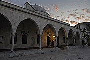
- The Habib'i Neccar Mosque, the oldest mosque in Antakya and one of the oldest in Anatolia.
- The labyrinth of narrow streets and old Antakya houses. This district is the oldtown in fact.
- Vespasianus Titus Tunnel-Samandagı. It is approximately 35 km. far from the centre.
- Beşikli Cave and Graves (the antique city of Seleukeia Pierria)
- St. Simon Monastery
- Bagras (Bakras) Castle, which was built in antiquity and restored many times in later centuries (particularly during the Crusades, when it was a stronghold of the Knights Templar), served as a watchtower on the 27 km (17 mi) mountain road from İskenderun (Alexandretta) to Antakya (Antioch).
- The panoramic view of the city from the heights of Mount Habib-i Neccar
- St. Paul Orthodox Church
With its rich architectural heritage, Antakya is a member of the Norwich-based European Association of Historic Towns and Regions.[37] The Roman bridge (thought to date from the era of Diocletian) was destroyed in 1972 during the widening and channelling of the Orontes.[citation needed]

-
 Antakya Yeni Camii Exterior
 -
 Antakya Habib-i Neccar Camii Interior
 -
 Antakya Habib-i Neccar Camii Exterior
 -
 Antakya Sarimiye Mosque Minaret
 -
 Antakya Ulu Cami Entrance to courtyard
 -
 Antakya Ulu Cami
 -
 Antakya Ulu Cami
 -
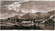 View of the river in the 1780s, by Louis-François Cassas.
 -
 Medina gate in the 1780s, by Louis-François Cassas.
 -
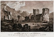 Ruins of the Seleucus palace in the 1780s, by Louis-François Cassas.
 -
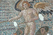 Mosaics of Eros are standing on the wings of two Psyches and whipping them on in Hatay Archaeology Museum
 -
 Dionysus mosaic in Hatay Archaeology Museum


.jpg)


Transport
The city is served from Hatay Airport.
Sports
Antakya has one male professional
Cuisine
The cuisine of Antakya is renowned. Its cuisine is considered Levantine rather than Turkish. The cuisine offers plenty of meals, where beef and lamb are mainly used. Popular dishes include the typical Turkish kebab, served with spices and onions in flat unleavened bread, with yoghurt as ali nazik kebab, oruk, kaytaz böreği and katıklı ekmek. Hot, spicy food is a feature of this part of Turkey, along with Turkish coffee and local specialties. Here are some savoury foods:
- İçli köfte and other wheat stuffed with minced meat; or baked in ovens in cylinder-cone shape. Saç oruğu is made of the same ingredients, however in circular shape.
- Kaytaz böreği: It is patty that is made of wheat, beef, tomato and onion.
- Katıklı ekmek: Ingredients in Katıklı Ekmek usually consist of wheat, traditional pepper (paste), spices such as sesame and theme, çökelek or cheese. It looks like an ancestor of pizza. Not a lot of restaurants serve it, however it can be found in old-market that is located in the centre and Harbiye.
- Pomegranate syrup, used as a salad dressing, called debes ramman, a traditional Levantine Arabic dressing.
- Semirsek, a thin bread with hot pepper, minced meat or spinach filling
- Spicy chicken, a specialty of Harbiye
- Za'atar (Zahter) a traditional Levantine Arabic paste of spiced thyme, oregano, and sesame seeds, mixed with olive oil, spread on flat (called pide or in English pita) bread.
- Fresh chick peas, munched as a snack.
- Hirise, boiled and pounded wheat meal.
- Aşur, meat mixed with crushed wheat, chickpea, cumin, onion, pepper and walnut
- Hummus - the chick-pea dip
- pureed fava beans
- Patlıcan salatası: Patlıcan salatası or babaganoush, made of baked and sliced aubergines that mixed with pepper and tomato. It is usually served with pomegranate syrup.
- Taratur: Known also as Tarator, made of walnuts, 'tahin', yoghurt and garlic.
- Süzme yoğurt: A type of yoghurt that its water content is removed with traditional methods.
- Ezme biber: It is made of pepper and walnuts.
- curdsserved in spicy olive oil
- Çökelek - the spicy sun-dried cheese
- Eels from the Orontes, spiced and fried in olive oil
- Sweets/desserts
- Künefe - a hot cheese, kadaif-based sweet. Antakya is Turkey's künefe capital; the pastry shops in the centre compete to claim being kings Turkish: kral of the pastry.[citation needed]
- Müşebbek - rings of deep fried pastry.
- Peynirli irmik helvası - Peynirli İrmik Helvası is a dessert that is made of semolina, sugar and traditional cheese that is the same as used in künefe. It is served warm, especially in restaurants in the region Harbiye, rather than künefe shops that are located in the centre.
Twin towns
Antakya is
 Aalen, Germany (since 1995).
Notable people
- Alexandros (1st century BC) Greek sculptor
- George of Antioch
- Ignatius of Antioch, Patriarch of Antioch
- John Chrysostom (349–407) Patriarch of Constantinople
- Gospel of St. Luke and Acts of the Apostles
- Seljukidgovernor of the city up to its capture by the Crusaders
- Righteous among the nations
- Republic of Hatayduring its existence between the years 1938 and 1939.
References
- ^ TÜİK. Retrieved 19 September 2023.
- ^ Nakib, Bülent (2004). Antakya ağzı: dilbilgisi ve sözlük (in Turkish). Hatay Folklor Araştırmaları Derneği. p. 43.
Anteke : Antakya adının Antakya ağzında söyleniş biçimi
- ^ Büyükşehir İlçe Belediyesi, Turkey Civil Administration Departments Inventory. Retrieved 19 September 2023.
- ^ "İl ve İlçe Yüz ölçümleri". General Directorate of Mapping. Retrieved 19 September 2023.
- ^ "The mixture of Roman, Greek, and Jewish elements admirably adapted Antioch for the great part it played in the early history of Christianity. The city was the cradle of the church." — "Antioch," Encyclopaedia Biblica, Vol. I, p. 186 (p. 125 of 612 in online .pdf file. Warning: Takes several minutes to download).
- ^ "Acts 11:26 - The Church at Antioch". Bible Hub.
- ISBN 9781612346618.
- ^ ISBN 9788872103104.
- ISBN 9781501707971.
- ^ Borges, Anelise (2023-02-10). "'Antakya is finished': Thousands left homeless in ruined city". euronews. Retrieved 2023-02-12.
- ^ "Lütfü Savaş: Hatay'da 20 bin kişi öldü, 24 bin yaralı vartrans-title=Lütfü Savaş: 20 thousand people died and 24 thousand were injured in Hatay" (in Turkish). Artı Gerçek. 18 February 2023. Retrieved 18 November 2023.
- ^ "Ahemed b. Tolun".
- ^ a b Rockwell 1911, p. 131.
- ^ ISBN 9780415737210.
- ^ "History of Armenia by Vahan Kurkjian – Chapter 30". penelope.uchicago.edu.
- ^ Sarah D. Shields, Fezzes in the River: Identity Politics and European Diplomacy in the Middle East on the Eve of World War II, 2011
- ^ "Law No. 6360". Official Gazette (in Turkish). 6 December 2012.
- ^ "İl İdaresi ve Mülki Bölümler Şube Müdürlüğü İstatistikleri - İl ve İlçe Kuruluş Tarihleri" (PDF) (in Turkish). p. 39. Retrieved 20 September 2023.
- ^ Travels in Africa, Egypt, and Syria, from the Year 1792 to 1798, by William George Browne, year 1806 on page 449 (and page 442 for Aleppo).
- ^ ISBN 9781576079195.
- ^ ISBN 9781781907276.
- ^ "Last Jew Of Antakya, A 2,300-Year-Old Jewish Community, Puts On Tefillin And Says 'I'm Leaving'". VINnews. Vos Iz Neias?. 20 February 2023. Retrieved 20 February 2023.
- ^ "Christian Arab Congregation In Antakya, Turkey". Edge of Humanity Magazine. 7 February 2017.
- ^ Chudacoff, Danya (May 14, 2014). "Turkey's Jewish community longs for the past". Aljazeera. Retrieved February 18, 2018.
- ^ Avotaynu: the international review of Jewish genealogy, Volume 14, G. Mokotoff, 1998, p. 40.
- ^ Rahav-Meir, Sivan (20 February 2023). "The last Jew of Antakya". Israel National News. Retrieved 20 February 2023.
- ^ "Turkey earthquake: BBC reports from Antakya, a city reduced to rubble". BBC. Retrieved 8 February 2023.
- ^ a b Hubbard, Ben; Kirac, Nimet (1 October 2023). "An Ancient City, Now in Ruins, Struggles to Keep Its Soul". The New York Times. Retrieved 18 November 2023.
- ^ "Hatay'da son durum: '2 bine yakın yıkılmış bina var, kayıplarımız çok fazla'" [The latest situation in Hatay: 'There are nearly 2,000 destroyed buildings, our losses are too high']. BBC News (in Turkish). 6 February 2023. Retrieved 7 February 2023.
- ^ "ASIA/TURKEY - Antioch, the earthquake destroys mosques and churches. Catholic parish welcomes displaced people". agenzia fides. Retrieved 8 February 2023.
- ^ Gct (2023-02-07). "The Historic Antakya Greek Orthodox Church In Hatay Damaged By The Earthquake". Retrieved 2023-02-09.
- ^ "Turkey earthquake: 2500-year-old Jewish presence in Antakya may come to an end". Middle East Eye. Retrieved 2023-02-15.
- ^ "Hatay'daki yıkım SÖZCÜ muhabirinin objektifine böyle yansıdı" [This is how the destruction in Hatay was reflected in the lens of SÖZCÜ reporter]. sozcu.com.tr (in Turkish). 7 February 2023. Archived from the original on 7 February 2023. Retrieved 7 February 2023.
- ^ Mahalle, Turkey Civil Administration Departments Inventory. Retrieved 19 September 2023.
- ^ "Resmi İstatistikler: İllerimize Ait Mevism Normalleri (1991–2020)" (in Turkish). Turkish State Meteorological Service. Retrieved 28 June 2021.
- ^ "About Mustafa Kemal University (MKU)". MKU. Retrieved 2011-03-26.
- ^ Association of Historic Towns of Turkey
- Glanville Downey (1963). Ancient Antioch. Princeton University Press.
- Rockwell, William Walker (1911). . In Chisholm, Hugh (ed.). Encyclopædia Britannica. Vol. 2 (11th ed.). Cambridge University Press. pp. 130–132.