
Baltimore–Washington Parkway
| ||||
|---|---|---|---|---|
| Restrictions | No commercial vehicles south of MD 175[a] | |||
| Major junctions | ||||
| South end | ||||
| ||||
| North end | ||||
| Location | ||||
| Country | United States | |||
| State | Maryland | |||
| Counties | Prince George's, Anne Arundel, Baltimore, City of Baltimore | |||
| Highway system | ||||
| ||||
The Baltimore–Washington Parkway (also referred to as the B–W Parkway) is a
Upon entering Baltimore, the
Plans for a parkway linking Baltimore and Washington date back to Pierre Charles L'Enfant's original layout for Washington, D.C. in the 18th century but did not fully develop until the 1920s. Major reasons surrounding the need for a parkway included high accident rates on adjacent US 1 and defense purposes before World War II. In the mid-1940s, plans for the design of the parkway were finalized and construction began in 1947 for the state-maintained portion and in 1950 for the NPS-maintained segment. The entire parkway opened to traffic in stages between 1950 and 1954.
Following completion of the B–W Parkway, suburban growth took place in both Washington, D.C. and Baltimore. In the 1960s and the 1970s, there were plans to give the segment of the parkway owned by the NPS to the state and make it a part of
Route description
NPS segment
The parkway begins at a large hybrid
_at_the_exit_for_Maryland_State_Route_450_(Bladensburg,_Annapolis)_in_Landover,_Prince_George%27s_County,_Maryland.jpg)
The portion of the B–W Parkway between the southern terminus and
It continues north as a four-lane
_from_the_Spellman_Overpass_in_Greenbelt,_Prince_George%27s_County,_Maryland.jpg)
Just past the Capital Beltway, the route heads into the heart of the city of Greenbelt, having an interchange with
Outside the Beltsville Agricultural Research Center, the parkway comes to
_just_south_of_Maryland_State_Route_175_(Jessup_Road)_in_Jessup,_Anne_Arundel_County,_Maryland.jpg)
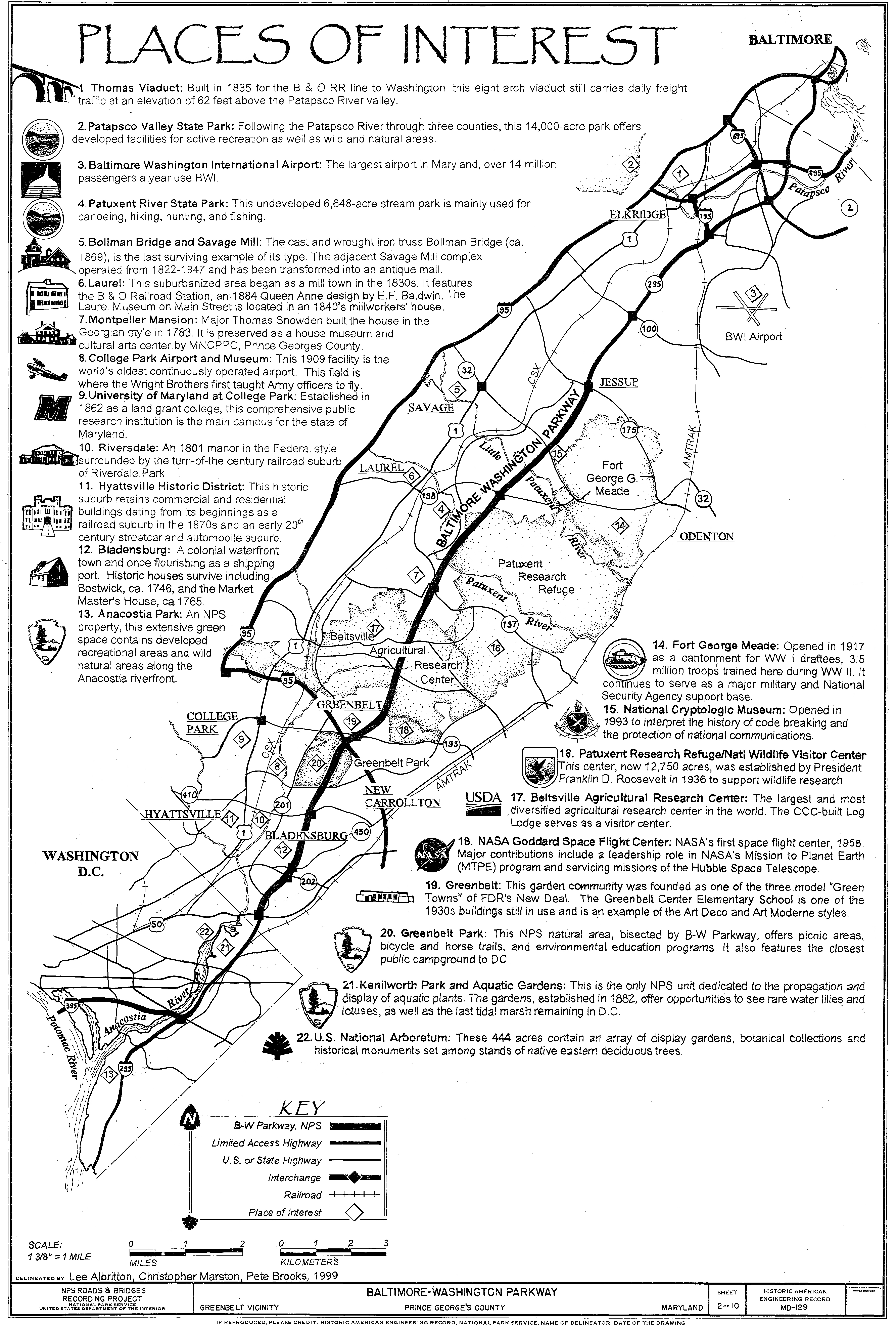
Continuing north, the parkway encounters MD 32 (Savage Road) near Fort Meade.[1][4] MD 32 offers northbound travelers direct access into the fort and to the National Security Agency, while the next interchange, another employee-only access road into Fort Meade, features only a southbound exit and northbound entrance.[4] Fort Meade itself is a military installation opened in 1917 that trained 3.5 million troops during World War II and is still a major fort. To the west of the parkway off MD 32 is the Savage Mill, which was an operating cotton mill from 1822 to 1947 and is currently an antique mall, and the Bollman Truss Railroad Bridge, an 1869 cast and wrought iron bridge along the Baltimore and Ohio Railroad, which is now CSX's Capital Subdivision, line between Baltimore and Washington D.C.[6] After this interchange, the road continues to a cloverleaf interchange with MD 175 (Jessup Road), where NPS maintenance of the parkway comes to an end at the south end of the interchange.[1][4]
Maryland Route 295
_just_north_of_Maryland_State_Route_175_(Jessup_Road)_in_Severn,_Anne_Arundel_County,_Maryland.jpg)
Past the MD 175 junction, MD 295 signage begins and the road continues north as a four-lane grade-separated freeway maintained by the Maryland State Highway Administration, where the truck ban ends. This permits trucks to serve into Fort Meade from Baltimore and BWI Airport. This section of the road features standard MUTCD green signage. It heads through wooded areas and comes to a
Still on a northeast track, the route widens to six lanes and intersects West Nursery Road near
In Baltimore, MD 295 continues as a limited-access freeway maintained by the
_near_West_Camden_Street_in_downtown_Baltimore_City,_Maryland.jpg)
MD 295 continues northeast on Russell Street, where it is unsigned for the remainder of the route, through a mix of industrial and commercial areas, heading to the northwest of the
Greene Street passes the
History

Planning
Plans for a parkway connecting Baltimore and Washington date back to the 1920s as a part of a system that was initially included in
Early proposals made by the
In 1942, the
Construction
Construction on the northern portion of the highway began in 1947 by the state of Maryland, while construction on the NPS segment started in 1950.
Post-construction
Around the time the highway was completed, the federal government began to promote suburbanization by moving several federal agencies out of the capital in order to protect them against nuclear attack.[16] As a result, suburban neighborhoods began to appear in Laurel, Severn, Bowie, and Greenbelt. In addition, the road became a prime commuting route into both Washington and Baltimore, leading to suburban growth that would eventually cause the two distinct cities to merge into one large metropolitan area.[17]
In 1963, the State Roads Commission, the National Park Service, and the Bureau of Public Roads (the predecessor of the Federal Highway Administration) (FHWA) created tentative plans to transfer the NPS segment of the parkway to the state of Maryland, who would then rebuild it to modern freeway standards, with trucks and buses permitted throughout.[18] The plan collapsed due to the state's reluctance to spend the money necessary to reconstruct the parkway, which was one of the most dangerous roads in the NPS road system.[19]
In 1965, the Goddard Space Flight Center constructed the interchange for its employee entrance.[20]
_from_the_overpass_for_the_ramp_from_southbound_Interstate_95_to_southbound_Maryland_State_Route_295_in_Baltimore_City,_Maryland.jpg)
In 1968, the State Roads Commission proposed to the FHWA that the parkway be included in the
By 1973, MD 3 was designated along the Baltimore–Washington Expressway between I-695 and Monroe Street in Baltimore.[25] MD 295 was designated along the state-maintained portions of the expressway, replacing the MD 3 designation between I-695 and Monroe Street, by 1981.[26] By the 1990s, the portion of the road known as the Baltimore–Washington Expressway became known as the Baltimore–Washington Parkway.[27]
In the mid-1980s, the National Park Service, along with the Federal Highway Administration, began a reconstruction of the NPS segment to modernize the road, including the improvement of several interchanges.[28] Around 2002, the federal government completed the project with the reconstruction of the MD 197 interchange.[28][29]
In 2004, Maryland Governor
The

Dedications
In 1983, the NPS-maintained section of the Baltimore–Washington Parkway was named in honor of
Incidents
In 1989, an overpass being built at MD 198 over the B–W Parkway just east of Laurel collapsed during rush hour, injuring fourteen motorists and construction workers. The incident was blamed on faulty scaffolding used to support the uncompleted span.[41] On July 9, 2005, a sinkhole opened beneath the parkway at a construction site, leading to the complete closure of the northbound roadway. The sinkhole was filled with concrete to shore up the roadbed and prevent further collapse; the U.S. Army Corps of Engineers attempted to expedite repairs, but the route remained closed until the next day.[42] On August 24, 2007, both directions of the parkway were closed when chunks of concrete fell from the overpass at MD 193 (Greenbelt Road) onto the northbound lanes.[43]
Renovation
_just_south_of_Interstate_695_(Baltimore_Beltway)_in_Linthicum,_Anne_Arundel_County,_Maryland.jpg)
MD 295 is planned to be widened to six lanes between MD 100 and I-195, and a new interchange is planned to be constructed at Hanover Road. The type of interchange has not yet been decided upon with choices including a diamond interchange, a single-point urban interchange, and a modified cloverleaf interchange. Planning for the $24 million project concluded in 2012.[44]
In September 2017, Governor
In 2019, portions of the National Park Service segment of the Baltimore–Washington Parkway experienced significant pavement deterioration, including several potholes. In March 2019, the speed limit was reduced on the section of the parkway between MD 197 and MD 32 due to poor road conditions.[46] After pressure from Governor Hogan and the state's congressional delegation, the National Park Service announced that emergency pothole repairs will take place from MD 197 to MD 198 on the weekend of March 30–31, 2019, with a complete repave to begin in April 2019, several months ahead of schedule. Repaving of the section between MD 198 and MD 175 occurred later in the year.[47]
Exit list
All exits are unnumbered.
}}
| County | Location | mi [1][2] | km | Destinations | Notes |
|---|---|---|---|---|---|
| Prince George's | Tuxedo | 0.00 | 0.00 | Southern terminus of MD 295 and Baltimore–Washington Parkway | |
| Southbound exit and northbound entrance | |||||
| Bladensburg | 1.65 | 2.66 | |||
| 1.97 | 3.17 | ||||
Riverdale | 3.63 | 5.84 | |||
Baltimore, Andrews AFB, Richmond | |||||
| Greenbelt | 6.36 | 10.24 | |||
| 7.53 | 12.12 | Goddard Space Flight Center (employees only) | |||
| South Laurel | 9.65 | 15.53 | Powder Mill Road – Beltsville | ||
| | 11.51 | 18.52 | |||
| Anne Arundel | | 14.86 | 23.91 | ||
| | 16.61 | 26.73 | Exits 10B-C on MD 32; access to Canine Road via MD 295 north only; serves National Cryptologic Museum | ||
| | 17.04 | 27.42 | NSA (restricted entrance) | Southbound exit and northbound entrance | |
| | 18.56 | 29.87 | NPS–MDSHA jurisdictional boundary | ||
| | 18.81 | 30.27 | Access to Jessup MARC Station via MD 175 west; commercial vehicles must exit here | ||
| | 20.05 | 32.27 | MD 713F) | Diverging diamond interchange; access to Live! Casino & Hotel | |
| | 21.31 | 34.30 | Exits 10A-B on MD 100 | ||
| | 24.21 | 38.96 | BWI Airport, Catonsville | Exits 2A-B on I-195; former MD 46 | |
| | 25.42 | 40.91 | West Nursery Road – BWI Hotel District | ||
Key Bridge | |||||
I-895 Toll north (Baltimore Harbor Tunnel Thruway ) | Northbound exit and southbound entrance; no exit before toll on I-895 | ||||
| | 28.88 | 46.48 | Baltimore DOT jurisdictional boundary) | ||
| Baltimore City | 29.89 | 48.10 | Southbound exit and entrance | ||
| Waterview Avenue | Northbound exit and entrance, access to Cherry Hill station | ||||
| 30.11 | 48.46 | Westport Light Rail station | |||
| 30.53 | 49.13 | Same-directional movements only | |||
| 30.53 | 49.13 | ||||
| 30.53 | 49.13 | Northern terminus of Baltimore–Washington Parkway; southern terminus of Russell Street | |||
| 31.52 | 50.73 | Northbound exit and southbound entrance (except Hamburg Street) | |||
| 32.45 | 52.22 | ||||
| 32.52 | 52.34 | Northern terminus of MD 295 | |||
| 1.000 mi = 1.609 km; 1.000 km = 0.621 mi | |||||
See also
 Maryland Roads portal
 National Register of Historic Places portal
- National Register of Historic Places listings in Anne Arundel County, Maryland
- National Register of Historic Places listings in Prince George's County, Maryland
- National Register of Historic Places listings in Baltimore County, Maryland
- National Register of Historic Places listings in Baltimore, Maryland
Notes
References
- ^ a b c d e f g h i j k l m n o Highway Information Services Division (December 31, 2013). Highway Location Reference. Maryland State Highway Administration. Retrieved March 2, 2012.
- Prince George's County (PDF).
- Anne Arundel County (PDF).
- Baltimore County (PDF).
- ^ a b c d e Highway Information Services Division (December 31, 2005). Highway Location Reference. Maryland State Highway Administration. Retrieved March 2, 2012.
- Baltimore City (PDF).[dead link]
- ^ "Baltimore–Washington Parkway Management". National Park Service.
- ^ a b c d e f g h i j k l m n o p q r s t u v w x y z Google (April 15, 2009). "Overview of Maryland Route 295" (Map). Google Maps. Google. Retrieved April 15, 2009.
- ^ "Baltimore–Washington Parkway: Fees & Reservations". National Park Service. Archived from the original on May 7, 2009. Retrieved April 15, 2009.
- ^ a b c d e f g h i j k "Map of the Baltimore–Washington Parkway". National Park Service. Retrieved July 3, 2009.
- ^ "Baltimore–Washington Parkway: United States Park Police". National Park Service. Archived from the original on May 9, 2009. Retrieved April 23, 2009.
- ^ a b "Parkways of the National Capital Region, 1913 - 1965" (PDF). National Park Service. Archived (PDF) from the original on May 2, 2009. Retrieved April 22, 2009.
- ^ a b "Major transportation milestones in the Baltimore region since 1940" (PDF). Baltimore Metropolitan Council. Archived from the original (PDF) on December 27, 2010. Retrieved April 21, 2009.
- ^ McBee, Avery (October 11, 1936). "Baltimore–Washington Parkway: A New Link Is Projected with the Nation's Capital". The Baltimore Sun (Sunday Sun Magazine). p. 3.
- ^ Duensing, Dawn (2000). "Baltimore–Washington Parkway" (PDF). Historic American Engineering Record. Washington, D.C.: Library of Congress. p. 1. Retrieved March 2, 2014.
- ^ a b "Baltimore–Washington Parkway". Maryland Historical Trust. Retrieved April 22, 2009.
- ^ a b "The Baltimore–Washington Parkway". Baltimore Magazine. August 1950.[page needed]
- ^ "Greenbelt Park". Potomac Appalachian Trail Club. Archived from the original on November 27, 2010. Retrieved April 22, 2009.
- ^ Exxon; General Drafting (1975). Delaware, Maryland, Virginia, West Virginia (Map). Exxon.[full citation needed]
- ^ "B.2 History of Suburbanization in Maryland" (PDF). Maryland State Highway Administration. Retrieved April 22, 2009.
- ^ "B.3.3 Modern Period (1930-1960)" (PDF). Maryland State Highway Administration. Retrieved April 22, 2009.
- Baltimore News-Post. August 16, 1963.[page needed]
- ^ "State Is Found Unwilling to Take Over the Parkway". The Baltimore Sun. April 20, 1969. p. 20.
- National Aeronautics and Space Administration. March 17, 1971. p. 16. Retrieved September 15, 2016.
- ^ Ayres, Horace (August 22, 1969). "Parkway Won't Become Part of Interstate". The Evening Sun. Baltimore, Maryland. p. C4.
- Gross Domestic Product deflatorfigures follow the MeasuringWorth series.
- ^ Dilts, James D. (December 9, 1974). "Battle Brews on Widening of Baltimore-DC Road". The Baltimore Sun. p. C1.
- ^ Rascovar, Barry C. (July 5, 1976). "Parkway Plans Narrowed". The Baltimore Sun. p. C1.
- ^ Exxon; General Drafting (1973). Baltimore and vicinity (Map). Exxon.[full citation needed]
- ^ Exxon; General Drafting (1981). Delaware, Maryland, Virginia, West Virginia (Map). Exxon.[full citation needed]
- ^ Rand McNally (1996). United States-Canada-Mexico Road Atlas (Map). Chicago: Rand McNally.[full citation needed]
- ^ a b "Reconstruction on Final Segment Of B-W Parkway to Begin Today". United States Department of Transportation. July 6, 1999. Archived from the original on July 19, 2008. Retrieved April 21, 2009.
- ^ "Statement of Mary Peters". United States Department of Transportation. August 8, 2002. Archived from the original on April 23, 2009. Retrieved April 22, 2009.
- ^ Kosmetatos, Sofia (October 29, 2004). "Counties get details of state plans for divvying up new funds for". Daily Record.[page needed]
- ^ "Lanes To Be Added To Baltimore–Washington Parkway". WJZ-TV. October 23, 2008.
- ^ "MD 0295 Baltimore/Washington Parkway RI- I-695 to I-195". Maryland State Highway Administration. Retrieved April 20, 2009.
- ^ Fuller, Nicole (May 1, 2012). "Temporary Road Closures Planned Around Arundel Mills". The Baltimore Sun. Archived from the original on February 1, 2014. Retrieved May 1, 2012.
- ^ Wild, Whitney (June 11, 2012). "Interchange opens at 295 and Arundel Mills Boulevard". WJLA-TV. Archived from the original on December 3, 2013. Retrieved July 11, 2012.
- ^ "Drivers Navigate Maryland's First Diverging Diamond Interchange". Maryland State Highway Administration. Retrieved April 8, 2014.
- ^ "S.680 A bill entitled the "Gladys Noon Spellman Parkway."". GovTrack. Retrieved August 14, 2021.
- ^ "Baltimore–Washington Parkway: History & Culture". National Park Service. Archived from the original on May 9, 2009. Retrieved April 22, 2009.
- ^ Leach, Sara Amy (March 28, 1991). "National Register of Historic Places Nomination: Baltimore–Washington Parkway". National Park Service. Retrieved September 13, 2018.
- ^ Leach, Sara Amy (March 28, 1991). "National Register of Historic Places Nomination: Baltimore–Washington Parkway". National Park Service. Retrieved September 13, 2018.
- ^ Leach, Sara Amy (April 1, 1988). "National Register of Historic Places Nomination: Baltimore–Washington Parkway". National Park Service. Retrieved September 13, 2018. with photos
- ^ Duggan, Paul and Veronica T. Jennings (September 1, 1989). "Overpass Collapses on B-W Parkway, Injuring Fourteen". The Washington Post. Retrieved September 18, 2020.
- ^ Rucker, Philip and Nick Anderson (July 9, 2005). "Rains Open B-W Parkway Sinkhole". The Washington Post. Retrieved January 30, 2007.
- ^ Harris, Hamil R. (August 25, 2007). "Falling Concrete Shuts Down B-W Parkway". The Washington Post. Retrieved April 20, 2009.
- ^ "MD 0295 Baltimore/Washington Parkway MD 100 to I-695 and Hanover Road". Maryland State Highway Administration. Retrieved April 20, 2009.
- ^ "Hogan proposes $9B plan to add new lanes to Beltway, 270 and BW Parkway". Washington, DC: WTOP-FM. September 21, 2017. Retrieved September 21, 2017.
- ^ Campbell, Colin (March 5, 2019). "The potholes are so bad on a stretch of the Baltimore-Washington Parkway that the speed limit was lowered". The Baltimore Sun. Archived from the original on March 31, 2019. Retrieved March 28, 2019.
- ^ Campbell, Colin (March 27, 2019). "National Park Service to begin emergency repairs on Baltimore-Washington Parkway amid pressure from lawmakers". The Baltimore Sun. Archived from the original on March 29, 2019. Retrieved March 28, 2019.
External links
- MD 295 at MDRoads.com
- MD 295 - Baltimore-Washington Parkway at AARoads.com
- Maryland Roads - MD 295, Balto-Wash Pkwy.
- National Park Service - Baltimore–Washington Parkway
- Steve Anderson's DCroads.net: Baltimore–Washington Parkway (MD 295)
- Historic American Engineering Record (HAER) No. MD-129, "Baltimore–Washington Parkway, Greenbelt vicinity, Prince George's County, MD", 49 photos, 2 color transparencies, 10 measured drawings, 146 data pages, 5 photo caption pages