
Banderas monumentales


The banderas monumentales (
The 1999 decree
On July 1, 1999, President Zedillo officially started the flag program by issuing a decree that was published in the government register
The flag program
The deployment of banderas monumentales was outlined by Zedillo in a two-point program. The first point consisted of selecting the location for the monumental flags, of which the first were:
- Those in the military base downtown, and in the San Jerónimo roundabout in Mexico City
- Tijuana, Baja California
- Ciudad Juárez, Chihuahua
- Veracuz, Veracruz
- Iguala, Guerrero
The first two deployments were in México City, Mexico's capital. The next two were in Tijuana and Ciudad Juárez, along the northern border with the
The second point in the program accounted for the creation of a standard size for the flags and the poles they would be raised on. Zedillo's official decree stated that the flag sizes will be 14.3 metres (47 ft) in height by 25 metres (82 ft) in width. The flag size is close to the 4:7 ratio as stated in Article 3 of the
There have been smaller flags called banderas semi-monumentales installed for schools, smaller communities and other locations where logistics complicate the flying a giant flag. The flags are greatly smaller than its those outlined in the 1999 decree, but have the advantages that are cheaper and easier to take down than the monumental flags. Monumental flags are costly to construct and require a group of nearly twenty people to raise and lower them.
Biggest flags
The biggest monumental flag in Mexico is the one located in Monterrey (northeast) with a pole height of 100.6 metres (330 ft) and a flag measuring 50 by 28.6 metres (164 by 94 ft), built to quadruple the size of the other monumental flags. It is located at the top of the Cerro del Obispado (Bishopric Hill) at an altitude of 775 metres (2,543 ft) above sea level and it weighs 230 kilograms (510 lb). It was inaugurated on the Día de la Bandera (Flag Day), February 24, 2005. Another flag with similar proportions is located in the city of Dolores Hidalgo, Guanajuato, the Cradle of Mexican Independence. This one was inaugurated on September 15, 2000 and it is at an altitude of 2,000 metres (6,600 ft) above the sea level, on a very small military base.
Current locations
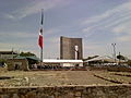
Since the construction of the first monumental flags, other cities throughout the country have also deployed their own. They are mostly located in state capitals, historical towns and cities with important economic activity.
- Monterrey, Nuevo León 25°40′34.33″N 100°20′45.98″W / 25.6762028°N 100.3461056°W
- Dolores Hidalgo, Cuna de la Independencia Nacional, Guanajuato 21°9′33.01″N 100°54′35.56″W / 21.1591694°N 100.9098778°W
- Querétaro, Querétaro
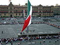
- México City(three locations):
- Zócalo, in the city center. 19°25′57.66″N 99°7′59.96″W / 19.4326833°N 99.1333222°W
- Campo Militar Marte (1 km northwest of Los Pinos) 19°25′27.14″N 99°11′47.84″W / 19.4242056°N 99.1966222°W
- San Jerónimo 19°19′52.11″N 99°12′39.56″W / 19.3311417°N 99.2109889°W
- Iguala, Guerrero 18°19′44.67″N 99°31′58.15″W / 18.3290750°N 99.5328194°W
- Tonalá, Jalisco
- Piedras Negras, Coahuila 28°42′00″N 100°31′23″W / 28.70000°N 100.52306°W
- Tijuana, Baja California 32°31′14.87″N 117°2′11.20″W / 32.5207972°N 117.0364444°W
- Chihuahua, Chihuahua
- Ciudad Juárez, Chihuahua 31°45′18.44″N 106°27′12.89″W / 31.7551222°N 106.4535806°W
- Veracruz, Veracruz
- Morelia, Michoacán
- Tehuacán, Puebla
- San Luis Potosí, San Luis Potosí
- El Calvario, Toluca
- Cuautla and Cuernavaca, Morelos
- Culiacán and Mazatlán, Sinaloa
- Yucatán
- Cancún, Quintana Roo
- Estado de México
- Nuevo Laredo, Tamaulipas 27°29′51.37″N 99°30′16.45″W / 27.4976028°N 99.5045694°W
- Ciudad Victoria, Tamaulipas
- Tampico, Tamaulipas
- Celaya, Guanajuato
- Irapuato, Guanajuato
- Ensenada, Baja California 31°51′33.51″N 116°37′27.34″W / 31.8593083°N 116.6242611°W
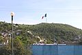
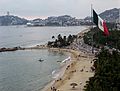
- Acapulco, Guerrero 16°51′31.89″N 99°53′12.35″W / 16.8588583°N 99.8867639°W
- San Miguel de Allende, Guanajuato
- Cozumel, Quintana Roo
The Tijuana, Ciudad Juárez and Nuevo Laredo flags overlook the United States border and can be clearly seen from the U. S. side.
Gallery
-
 Iguala, Guerrero
 -

-
 Corralejo Hidalgo, Pénjamo, Guanajuato
 -
 Cancún, Quintana Roo
 -
-

-
 Acapulco, Guerrero
 -

-
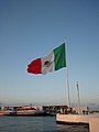
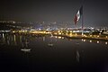 Ensenada, Baja California
 -
 Ensenada, Baja California
 -
 Tijuana, Baja California
 -

-
 El Calvario, Toluca
 -


.jpg)


