
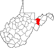
Bayard, West Virginia
Town of Bayard, West Virginia | ||
|---|---|---|
FIPS code 54-04924[4] | | |
| GNIS feature ID | 2390716[2] | |
Bayard is a town in
Geography
According to the United States Census Bureau, the town has a total area of 0.31 square miles (0.80 km2), all of it land.[6]
Climate
| Climate data for Bayard, West Virginia (1991–2020 normals, extremes 1902–present) | |||||||||||||
|---|---|---|---|---|---|---|---|---|---|---|---|---|---|
| Month | Jan | Feb | Mar | Apr | May | Jun | Jul | Aug | Sep | Oct | Nov | Dec | Year |
| Record high °F (°C) | 73 (23) |
79 (26) |
84 (29) |
89 (32) |
92 (33) |
94 (34) |
95 (35) |
95 (35) |
95 (35) |
92 (33) |
78 (26) |
74 (23) |
95 (35) |
| Mean daily maximum °F (°C) | 35.0 (1.7) |
38.2 (3.4) |
46.5 (8.1) |
59.0 (15.0) |
68.1 (20.1) |
75.6 (24.2) |
79.2 (26.2) |
78.0 (25.6) |
71.7 (22.1) |
60.9 (16.1) |
48.6 (9.2) |
39.1 (3.9) |
58.3 (14.6) |
| Daily mean °F (°C) | 25.5 (−3.6) |
28.2 (−2.1) |
35.5 (1.9) |
46.1 (7.8) |
55.6 (13.1) |
63.4 (17.4) |
67.3 (19.6) |
65.9 (18.8) |
59.3 (15.2) |
48.6 (9.2) |
37.8 (3.2) |
30.0 (−1.1) |
46.9 (8.3) |
| Mean daily minimum °F (°C) | 16.1 (−8.8) |
18.2 (−7.7) |
24.4 (−4.2) |
33.3 (0.7) |
43.1 (6.2) |
51.2 (10.7) |
55.4 (13.0) |
53.9 (12.2) |
46.8 (8.2) |
36.2 (2.3) |
27.0 (−2.8) |
20.9 (−6.2) |
35.5 (1.9) |
| Record low °F (°C) | −30 (−34) |
−25 (−32) |
−17 (−27) |
1 (−17) |
13 (−11) |
27 (−3) |
32 (0) |
28 (−2) |
15 (−9) |
8 (−13) |
−14 (−26) |
−20 (−29) |
−30 (−34) |
| Average precipitation inches (mm) | 4.27 (108) |
4.11 (104) |
4.53 (115) |
4.50 (114) |
5.39 (137) |
5.25 (133) |
5.55 (141) |
4.19 (106) |
3.93 (100) |
3.38 (86) |
3.33 (85) |
4.25 (108) |
52.68 (1,338) |
| Average snowfall inches (cm) | 31.9 (81) |
30.1 (76) |
19.6 (50) |
4.4 (11) |
0.0 (0.0) |
0.0 (0.0) |
0.0 (0.0) |
0.0 (0.0) |
0.0 (0.0) |
2.0 (5.1) |
7.5 (19) |
22.3 (57) |
117.8 (299) |
| Average precipitation days (≥ 0.01 in) | 20.9 | 18.2 | 17.3 | 16.0 | 16.5 | 14.3 | 13.2 | 12.9 | 11.1 | 12.6 | 13.6 | 18.6 | 185.2 |
| Average snowy days (≥ 0.1 in) | 12.9 | 11.0 | 7.6 | 2.0 | 0.0 | 0.0 | 0.0 | 0.0 | 0.0 | 0.8 | 3.4 | 9.5 | 47.2 |
| Source: NOAA[7][8] | |||||||||||||
Transportation
_at_Vine_Street_in_Bayard,_Grant_County,_West_Virginia.jpg)
The only significant road serving Bayard is West Virginia Route 90. Route 90 connects Bayard to U.S. Route 219 to the southwest, and U.S. Route 50 to the northeast. Within Bayard, Route 90 follows Front Street through the center of town.

Demographics
| Census | Pop. | Note | %± |
|---|---|---|---|
| 1900 | 540 | — | |
| 1910 | 417 | −22.8% | |
| 1920 | 1,074 | 157.6% | |
| 1930 | 743 | −30.8% | |
| 1940 | 585 | −21.3% | |
| 1950 | 589 | 0.7% | |
| 1960 | 484 | −17.8% | |
| 1970 | 475 | −1.9% | |
| 1980 | 540 | 13.7% | |
| 1990 | 414 | −23.3% | |
| 2000 | 299 | −27.8% | |
| 2010 | 290 | −3.0% | |
| 2020 | 200 | −31.0% | |
| 2021 (est.) | 199 | [3] | −0.5% |
| U.S. Decennial Census[9] | |||
2010 census
At the
Of the 126 households 28.6% had children under the age of 18 living with them, 56.3% were married couples living together, 6.3% had a female householder with no husband present, 5.6% had a male householder with no wife present, and 31.7% were non-families. 27.8% of households were one person and 8.8% were one person aged 65 or older. The average household size was 2.30 and the average family size was 2.80.
The median age in the town was 44.5 years. 19.3% of residents were under the age of 18; 5.6% were between the ages of 18 and 24; 26.5% were from 25 to 44; 29.3% were from 45 to 64; and 19.3% were 65 or older. The gender makeup of the town was 52.4% male and 47.6% female.
2000 census
At the
Of the 141 households 21.3% had children under the age of 18 living with them, 50.4% were married couples living together, 9.9% had a female householder with no husband present, and 34.0% were non-families. 29.8% of households were one person and 18.4% were one person aged 65 or older. The average household size was 2.12 and the average family size was 2.60.
The age distribution was 16.4% under the age of 18, 9.4% from 18 to 24, 21.7% from 25 to 44, 32.1% from 45 to 64, and 20.4% 65 or older. The median age was 46 years. For every 100 females, there were 104.8 males. For every 100 females age 18 and over, there were 101.6 males.
The median household income was $25,156 and the median family income was $31,750. Males had a median income of $30,313 versus $14,583 for females. The per capita income for the town was $13,882. About 7.2% of families and 14.3% of the population were below the
Climate
The climate in this area has mild differences between highs and lows, and there is adequate rainfall year-round. According to the
References
- ^ "2019 U.S. Gazetteer Files". United States Census Bureau. Retrieved August 7, 2020.
- ^ a b U.S. Geological Survey Geographic Names Information System: Bayard, West Virginia
- ^ a b c d "City and Town Population Totals: 2020-2021". Census.gov. US Census Bureau. Retrieved July 3, 2022.
- ^ a b "U.S. Census website". United States Census Bureau. Retrieved January 31, 2008.
- ^ Kenny, Hamill (1945). West Virginia Place Names: Their Origin and Meaning, Including the Nomenclature of the Streams and Mountains. Piedmont, WV: The Place Name Press. p. 98.
- ^ "US Gazetteer files 2010". United States Census Bureau. Archived from the original on January 25, 2012. Retrieved January 24, 2013.
- ^ "NOWData - NOAA Online Weather Data". National Oceanic and Atmospheric Administration. Retrieved October 14, 2023.
- ^ "Summary of Monthly Normals 1991-2020". National Oceanic and Atmospheric Administration. Retrieved October 14, 2023.
- ^ "Census of Population and Housing". Census.gov. Retrieved June 4, 2015.
- ^ "U.S. Census website". United States Census Bureau. Retrieved January 24, 2013.
- ^ Climate Summary for Bayard, West Virginia
 | ||||
Town | ||||
| Unincorporated communities | ||||
| Footnotes | ‡This populated place also has portions in an adjacent county or counties | |||
| ||||
| Authority control databases: National |
|---|