
Berkeley Springs, West Virginia
Berkeley Springs, West Virginia | ||
|---|---|---|
| Town of Bath | ||
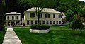
 Town square in Berkeley Springs | ||
|
FIPS code 54-04876 | | |
| GNIS feature ID | 1877535[2] | |
| Website | https://townofbath.org/government/ | |
Berkeley Springs is a town in, and the
The area contains mineral water springs frequented by
History

During colonial times in 1748,
While vacationing in the area in 1767, Washington noted how busy the colonial town had become. Lord Fairfax had built a summer home there and a "private bath", making the area a popular destination for Virginia's social elite. With the advent of independence, An act for establishing a town at the Warm Springs in the county of Berkeley[6] was adopted by the Virginia General Assembly in December 1776. Officially, the town was named Bath, in honor of England's spa city Bath.

George Washington, his family members, and several colonial elites were among the town's first landowners. The town's main north-south street was named Washington, and the main east-west street was named Fairfax. Also, four acres were set aside for "suffering humanity." The area around the springs always was public land known as The Grove and overseen by a state-appointed group of Beth Trustees. This would become
Bath's population increased during and immediately after the Revolutionary War as wounded soldiers and others came to the area believing that the warm springs had medicinal qualities.[citation needed]
Chronology of names
In 1772, the springs were part of the newly formed Berkeley County, named after its colonial governor, Norborne Berkeley. The waters became known as Berkeley Springs because the existing protocol was to name springs after the colonial Virginia county in which they were located. Previously, the area had been called Warm Springs and Medicinal Springs among other names.
Bath became known permanently to the world as Berkeley Springs in 1802 when the Virginia postal system was established in the new nation, and there already was a Bath, Virginia, in Bath County.
In 1861, many residents of Virginia were opposed to Virginia's secession from the United States, some calling the act of secession treasonous. Following the Wheeling Conventions of 1861, a referendum was held in 41 mostly northwestern Virginia counties on whether to secede from Virginia and seek admission to the United States as a new state. An overwhelming majority of voters in these counties voted in favor of the proposal. Confederates commanded by Stonewall Jackson captured Bath during the Romney Expedition in January 1862, and ransacked the homes of local unionists.[7] The United States admitted the State of West Virginia on June 20, 1863. Berkeley Springs remained the conventional name used for the town. Its sister city is Bath, England.
Geography
Berkeley Springs is located in the
According to the United States Census Bureau, the incorporated town of Bath has a total area of 0.34 square miles (0.88 km2), all land.[8]
There are two rivers in Morgan County. The Potomac makes up the northern border, and the Cacapon River cuts through the center of the county connecting with the Potomac at Great Cacapon. The Cacapon and Sleepy Creek Mountains are the two most notable mountains in the county. Berkeley Springs is nestled in the extreme northern Shenandoah Valley at an elevation of approximately 499 feet (152 m). Warm Spring Run cuts through the center of the town and eventually connects with the Potomac River near the Hancock Station. Sleepy Creek connects with the Potomac along River Road north and east of the town.
Demographics
| Census | Pop. | Note | %± |
|---|---|---|---|
| 1850 | 77 | — | |
| 1860 | 2,982 | 3,772.7% | |
| 1870 | 407 | −86.4% | |
| 1880 | 534 | 31.2% | |
| 1900 | 781 | — | |
| 1910 | 864 | 10.6% | |
| 1920 | 980 | 13.4% | |
| 1930 | 1,039 | 6.0% | |
| 1940 | 1,145 | 10.2% | |
| 1950 | 1,213 | 5.9% | |
| 1960 | 1,138 | −6.2% | |
| 1970 | 944 | −17.0% | |
| 1980 | 789 | −16.4% | |
| 1990 | 735 | −6.8% | |
| 2000 | 663 | −9.8% | |
| 2010 | 624 | −5.9% | |
| 2020 | 758 | 21.5% | |
| 2021 (est.) | 755 | [3] | −0.4% |
| U.S. Decennial Census[9] | |||
2010 census
As of the
There were 314 households, of which 23.9% had children under the age of 18 living with them, 31.8% were married couples living together, 14.6% had a female householder with no husband present, 3.8% had a male householder with no wife present, and 49.7% were non-families. 43.0% of all households were made up of individuals, and 17.5% had someone living alone who was 65 years of age or older. The average household size was 1.99, and the average family size was 2.74.
The median age in the town was 42.9 years. 21.2% of residents were under the age of 18; 6.5% were between the ages of 18 and 24; 25.1% were from 25 to 44; 27% were from 45 to 64; and 19.9% were 65 years of age or older. The gender makeup of the town was 47.8% male and 52.2% female.
2000 census
As of the
There were 331 households, out of which 20.5% had children under the age of 18 living with them, 35.6% were married couples living together, 10.0% had a female householder with no husband present, and 51.4% were non-families. 46.5% of all households were made up of individuals, and 25.1% had someone living alone who was 65 years of age or older. The average household size was 1.98, and the average family size was 2.85.
In the town, the population was spread out, with 19.5% under 18, 11.0% from 18 to 24, 23.4% from 25 to 44, 22.3% from 45 to 64, and 23.8% who were 65 years or older. The median age was 41 years. For every 100 females, there were 80.2 males. For every 100 females age 18 and over, there were 77.4 males.
The median income for a household in the town was $24,934, and the median income for a family was $33,333. Males had a median income of $25,156 versus $23,611 for females. The
Transportation
_between_Market_Street_and_Warren_Street_in_Berkeley_Springs_(Bath),_Morgan_County,_West_Virginia.jpg)
Two main highways serve Berkeley Springs. The most prominent of these is
Notable people
- Beirne Lay, Jr., U.S. Army aviator
- Tom Netherton, singer, Lawrence Welk Show
- Charles Triplett O'Ferrall, politician
- John Herbert Quick, author
- James Rumsey, early steamboat inventor
- David Hunter Strother, journalist, artist, politician and diplomat
In popular culture
A location in the
Gallery
-
 Storage bins no longer in use. At one time, they were used by the local sand mine for loading train cars for distribution.
 -
 View of part of Berkeley Springs State Park
 -
 Another view of part of Berkeley Springs State Park, with fall colors
 -
 View of Sleepy Creek Mountain from Devil's Nose
 -
 The former train station


References
- ^ "2019 U.S. Gazetteer Files". United States Census Bureau. Retrieved August 7, 2020.
- ^ a b U.S. Geological Survey Geographic Names Information System: Berkeley Springs, West Virginia
- ^ a b c "City and Town Population Totals: 2020-2021". Census.gov. US Census Bureau. Retrieved July 3, 2022.
- ^ "Find a County". National Association of Counties. Archived from the original on May 31, 2011. Retrieved June 7, 2011.
- ^ Berkeley Springs International Water Tasting
- ^ "Hening's Statutes at Large". vagenweb.org. Retrieved March 5, 2017.
- ISBN 978-0-8078-3200-4.
- ^ "US Gazetteer files 2010". United States Census Bureau. Archived from the original on July 2, 2012. Retrieved January 24, 2013.
- ^ United States Census Bureau. "Census of Population and Housing". Retrieved August 30, 2013.
- ^ "U.S. Census website". United States Census Bureau. Retrieved January 24, 2013.
- ^ "U.S. Census website". United States Census Bureau. Retrieved January 31, 2008.
- ^ Berkeley Springs - Fallout 76 Wiki Guide - IGN, retrieved April 7, 2020
External links
 Berkeley Springs travel guide from Wikivoyage
- Official Website of Town of Bath Government Berkeley Springs
- Official Website of Berkeley Springs
- Berkeley Springs – Morgan County Chamber of Commerce
 | ||||
| CDP | ||||
| Unincorporated communities |
| |||
| ||||
| International | |
|---|---|
| National | |