
Bicycle transportation planning and engineering

Bicycle transportation planning and engineering are the disciplines related to
Networks, signage and maps
The examples and perspective in this section deal primarily with Europe and do not represent a worldwide view of the subject. (April 2021) |
Most national cycling route networks have long-distance named routes, rather like highways. However, the international numbered-node cycle network has a modular design that enables arbitrary routes using simple signage. Both aim to minimize map use with plentiful signs.
Cycle networks of routes can be developed in co-ordination with cycle maps. Co-ordination can be local or national (the numbered-node cycle network has national co-ordination in some countries, and local co-ordination in others).
-
 Cycle Superhighway CS7 start point at Colliers Wood Underground Station]
 -
![Cycleway network in Milton Keynes. NCR routes 6 and 51 are highlighted in red. In 1970 in the United Kingdom, the Milton Keynes Development Corporation produced the "Master Plan for Milton Keynes".[3]](//upload.wikimedia.org/wikipedia/commons/thumb/3/37/Milton_Keynes_Redway.gif/518px-Milton_Keynes_Redway.gif) Cycleway network in Milton Keynes. NCR routes 6 and 51 are highlighted in red. In 1970 in the United Kingdom, the Milton Keynes Development Corporation produced the "Master Plan for Milton Keynes".[3]
Cycleway network in Milton Keynes. NCR routes 6 and 51 are highlighted in red. In 1970 in the United Kingdom, the Milton Keynes Development Corporation produced the "Master Plan for Milton Keynes".[3] -
 A locator map on the numbered-node cycle network, at node 20 in Schoten, near Antwerp. Each intersection is marked with a numbered circle; any route through the network can be represented as a string of numbers.

![Cycleway network in Milton Keynes. NCR routes 6 and 51 are highlighted in red. In 1970 in the United Kingdom, the Milton Keynes Development Corporation produced the "Master Plan for Milton Keynes".[3]](/File:Milton_Keynes_Redway.gif)

Bikeways
Some examples of the types of bikeways under the purview of bicycle transportation engineers include partially segregated infrastructure in-road such as bike lanes, buffered bike lanes; physically segregated in-road such as cycle tracks; bike paths with their own right-of-way; and shared facilities such as bicycle boulevards, shared lane markings, advisory bike lane, road shoulders, wide outside lanes, shared street schemes, and any roadways with legal access for cycling.
In roadway
Unsegregated
-
 One-way street with two-way shared cycling
 -
 Streetscape in which allmodes of travel(pedestrians, cyclists, and motorists) share the road
 -
 Streetscape in which cyclists and motorists share the road


Partially segregated
-
 Streetscape with dedicated cycle facilities next to other traffic

- Cycle lane
- Shared lane marking
Segregated
-
 One way street with two way cycle tracks and shared road
 -
 One way street with a single two way cycle track on right
 -
 One way street with a single two way cycle track on left
 -
 Cycle tracks with concrete barriers in downtown Ottawa, Ontario, Canada on Laurier Avenue in 2011.
 -
 Separate traffic light for automobiles and bicycles on cycle track in Denmark
 -
 Cycle track with green lanes through intersection in Ottawa, Ontario, Canada (also on Laurier) in 2011.


Barriers
Options for barriers are soft-hit posts, raised curb or traffic barriers.
Off road


Bike freeway
-
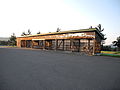
 The bicycle highway F35 in Enschede.

- Bike freeway
Intersections and signals
-

-
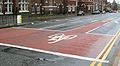 Advanced stop line, Liverpool, UK
 -
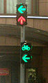 Signals for cyclists in China
 -


Bicycle transportation engineers also are involved in improving intersections/junctions and traffic lights. Advanced stop lines are one example of road markings on mixed mode shared space as cycling infrastructure.
Other infrastructure
-
-
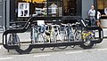 Bike rack shaped like a car


Legislation
See also
- Bikeway controversies
- Bicycle Master Plan
- Bikeway safety
- Cyclability
- CROW Design Manual for Bicycle Traffic
- Bicycle mobility
- Sustainable transport
- Outline of cycling
- Cycling infrastructure
- Mikael Colville-Andersen
References
- ^ "Association of Pedestrian and Bicycle Professionals". Retrieved 20 July 2015.
- ^ "Active Transportation". Federal Administration Department. Retrieved 18 August 2015.
- ^ Modern Milton Keynes: the master plan Archived 28 July 2012 at the Wayback Machine MK Web
| General and technical | |
|---|---|
| Utility and slow recreation | |
| Sports-related cycling and fast-paced recreation | |
| Health, safety and infrastructure |
|
| Other | |
| Lists | |
| In-roadway bikeways |
| ||||||
|---|---|---|---|---|---|---|---|
| Right-of-way paths |
| ||||||
| Health, safety and infrastructure |
| ||||||
| Design guidelines |
| ||||||