
Brinnon, Washington
Brinnon, Washington | ||
|---|---|---|
FIPS code 53-08080[2] | | |
| GNIS feature ID | 1516959[3] | |
Brinnon is a
Geography
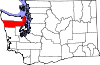
Brinnon is located approximately 61 miles (98 km) north of Olympia, on the Olympic Peninsula's east side. It sits on the west side of Hood Canal on the eastern edge of the Olympic National Forest. U.S. Route 101 runs the length of the community, leading south to Olympia and north 59 miles (95 km) to Port Angeles.
According to the United States Census Bureau, the CDP has a total area of 9.8 square miles (25.5 km2), of which 9.6 square miles (24.9 km2) are land and 0.3 square miles (0.7 km2), or 2.57%, are water.[4] The CDP extends from Wawa Point in the north, just south of Jackson Cove, to the Mason County line in the south at Triton Cove, and includes the unincorporated communities (from north to south) of Seal Rock, Brinnon, and Duckabush. The Dosewallips River crosses the north-central part of the CDP and enters Hood Canal at Brinnon Flats just north of the settlement of Brinnon, while the Duckabush River crosses the south-central part of the CDP, entering Hood Canal at Duckabush village, just south of Black Point.
Climate
Brinnon experiences an oceanic climate (Köppen climate classification Cfb) and is almost categorised as part of the Csb climate category, receiving slightly more than 30 mm (1.2 in), the threshold for Cfb inclusion.
| Climate data for Brinnon | |||||||||||||
|---|---|---|---|---|---|---|---|---|---|---|---|---|---|
| Month | Jan | Feb | Mar | Apr | May | Jun | Jul | Aug | Sep | Oct | Nov | Dec | Year |
| Mean daily maximum °F (°C) | 45 (7) |
50 (10) |
56 (13) |
61 (16) |
67 (19) |
72 (22) |
77 (25) |
79 (26) |
73 (23) |
62 (17) |
51 (11) |
44 (7) |
61 (16) |
| Mean daily minimum °F (°C) | 31 (−1) |
33 (1) |
35 (2) |
38 (3) |
43 (6) |
48 (9) |
51 (11) |
50 (10) |
46 (8) |
40 (4) |
35 (2) |
31 (−1) |
40 (4) |
| Average precipitation inches (mm) | 7.39 (188) |
7.38 (187) |
5.93 (151) |
3.81 (97) |
2.82 (72) |
2.13 (54) |
1.29 (33) |
1.24 (31) |
1.60 (41) |
4.13 (105) |
7.99 (203) |
8.65 (220) |
54.36 (1,381) |
| Source: [7] | |||||||||||||
Demographics
As of the
There were 413 households, out of which 10.7% had children under the age of 18 living with them, 55.2% were married couples living together, 5.1% had a female householder with no husband present, and 37.5% were non-families. 32.0% of all households were made up of individuals, and 14.5% had someone living alone who was 65 years of age or older. The average household size was 1.94 and the average family size was 2.36.
In the CDP, the population was spread out, with 10.7% under the age of 18, 3.1% from 18 to 24, 15.6% from 25 to 44, 34.9% from 45 to 64, and 35.7% who were 65 years of age or older. The median age was 58 years. For every 100 females, there were 110.2 males. For every 100 females age 18 and over, there were 110.9 males.
The median income for a household in the CDP was $27,885, and the median income for a family was $34,375. Males had a median income of $31,250 versus $16,500 for females. The
References
- ^ "US Gazetteer files: 2010, 2000, and 1990". United States Census Bureau. February 12, 2011. Retrieved April 23, 2011.
- ^ a b "U.S. Census website". United States Census Bureau. Retrieved January 31, 2008.
- ^ "Brinnon". Geographic Names Information System. United States Geological Survey, United States Department of the Interior.
- ^ a b "Geographic Identifiers: 2010 Demographic Profile Data (G001): Brinnon CDP, Washington". U.S. Census Bureau, American Factfinder. Retrieved January 3, 2019.[dead link]
- ^ Ruth Kirk and Carmela Alexander. Exploiting Washington's Past: A Rude Guide to History. University of Washington Press, 1995.
- ^ "Camp Parsons". Retrieved April 4, 2018.
- ^ "Average Weather for Brinnon". Weather.com. Retrieved May 13, 2008.
 | ||||
| CDPs | ||||
| Other communities | ||||
| Indian reservation |
| |||
| Ghost towns |
| |||
| Footnotes | ‡This populated place also has portions in an adjacent county or counties | |||
| International | |
|---|---|
| National | |