
Degersheim
Degersheim | |
|---|---|
 | |
 Coat of arms | |
Location of Degersheim  | |
Sankt Peterzell, Schwellbrunn (AR) | |
| Website | www SFSO statistics |
Degersheim is a
History
Degersheim is first mentioned in 837 as Tegarascai. It was known as Tegerschen until 1803, when Degersheim became the official name. The village of Wolfertswil is mentioned in 838 as Wolfrideswilare.[3]
Geography
Degersheim has an area, as of 2006[update], of 14.4 km2 (5.6 sq mi). Of this area, 53.4% is used for agricultural purposes, while 36.5% is forested. Of the rest of the land, 10% is settled (buildings or roads) and the remainder (0.1%) is non-productive (rivers or lakes).[4]
It consists of the village of Degersheim and the
Coat of arms
The blazon of the municipal coat of arms is Per pale sable an Ash tree eradicated Or and Or a Cross Lorraine Sable.[5]
Demographics
Degersheim has a population (as of 31 December 2020) of 4,099.[6] As of 2007[update], about 17.2% of the population was made up of foreign nationals. Of the foreign population, (as of 2000[update]), 40 are from Germany, 147 are from Italy, 275 are from ex-Yugoslavia, 27 are from Austria, 34 are from Turkey, and 183 are from another country.[7] Over the last 10 years the population has decreased at a rate of -1.5%. Most of the population (as of 2000[update]) speaks German (89.9%), with Italian being second most common ( 2.3%) and Spanish being third ( 1.8%).[4] Of the Swiss national languages (as of 2000[update]), 3,551 speak German, 8 people speak French, 91 people speak Italian, and 6 people speak Romansh.[8]
The age distribution, as of 2000[update], in Degersheim is; 515 children or 13.0% of the population are between 0 and 9 years old and 636 teenagers or 16.1% are between 10 and 19. Of the adult population, 428 people or 10.8% of the population are between 20 and 29 years old. 553 people or 14.0% are between 30 and 39, 585 people or 14.8% are between 40 and 49, and 479 people or 12.1% are between 50 and 59. The senior population distribution is 326 people or 8.2% of the population are between 60 and 69 years old, 224 people or 5.7% are between 70 and 79, there are 169 people or 4.3% who are between 80 and 89, and there are 36 people or 0.9% who are between 90 and 99, and 1 person who is 100 or more.[8]
In 2000[update] there were 486 persons (or 12.3% of the population) who were living alone in a private dwelling. There were 769 (or 19.5%) persons who were part of a couple (married or otherwise committed) without children, and 2,286 (or 57.8%) who were part of a couple with children. There were 197 (or 5.0%) people who lived in single parent home, while there are 25 persons who were adult children living with one or both parents, 16 persons who lived in a household made up of relatives, 8 who lived household made up of unrelated persons, and 165 who are either institutionalized or live in another type of collective housing.[8]
In the 2007 federal election the most popular party was the SVP which received 32.1% of the vote. The next three most popular parties were the CVP (19.7%), the FDP (16%) and the SP (13.9%).[4]
The entire Swiss population is generally well educated. In Degersheim about 68.2% of the population (between age 25-64) have completed either non-mandatory upper secondary education or additional higher education (either University or a Fachhochschule).[4] Out of the total population in Degersheim, as of 2000[update], the highest education level completed by 906 people (22.9% of the population) was Primary, while 1,329 (33.6%) have completed Secondary, 397 (10.0%) have attended a Tertiary school, and 191 (4.8%) are not in school. The remainder did not answer this question.[8]
The historical population is given in the following table:[3]
| year | population |
|---|---|
| 1816 | 1,067 |
| 1850 | 1,620 |
| 1900 | 3,414 |
| 1910 | 3,766 |
| 1941 | 2,966 |
| 1950 | 3,186 |
| 2000 | 3,952 |
Heritage sites of national significance

The former
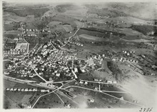
The village of Degersheim is designated as part of the Inventory of Swiss Heritage Sites.[10]
.jpg)
Economy
As of 2007[update], Degersheim had an unemployment rate of 1.25%. As of 2005[update], there were 138 people employed in the primary economic sector and about 50 businesses involved in this sector. 820 people are employed in the secondary sector and there are 64 businesses in this sector. 604 people are employed in the tertiary sector, with 114 businesses in this sector.[4]
As of October 2009[update] the average unemployment rate was 2.9%.[11] There were 226 businesses in the municipality of which 64 were involved in the secondary sector of the economy while 114 were involved in the third.[12]
As of 2000[update] there were 1,016 residents who worked in the municipality, while 989 residents worked outside Degersheim and 695 people commuted into the municipality for work.[13]
Religion

From the 2000 census[update], 1,739 or 44.0% are
Weather
Degersheim has an average of 153.6 days of rain or snow per year and on average receives 1,549 mm (61.0 in) of
See also
References
- ^ a b "Arealstatistik Standard - Gemeinden nach 4 Hauptbereichen". Federal Statistical Office. Retrieved 13 January 2019.
- ^ "Ständige Wohnbevölkerung nach Staatsangehörigkeitskategorie Geschlecht und Gemeinde; Provisorische Jahresergebnisse; 2018". Federal Statistical Office. 9 April 2019. Retrieved 11 April 2019.
- ^ a b Degersheim in German, French and Italian in the online Historical Dictionary of Switzerland.
- ^ a b c d e Swiss Federal Statistical Office Archived January 5, 2016, at the Wayback Machine accessed 20-January-2010
- ^ Flags of the World.com Archived 2011-06-04 at the Wayback Machine accessed 20-January-2010
- ^ "Ständige und nichtständige Wohnbevölkerung nach institutionellen Gliederungen, Geburtsort und Staatsangehörigkeit". bfs.admin.ch (in German). Swiss Federal Statistical Office - STAT-TAB. 31 December 2020. Retrieved 21 September 2021.
- ^ Der Kanton St. Gallen und seine Menschen in Zahlen - Ausgabe 2009 (in German) accessed 30 December 2009
- ^ a b c d e Canton St. Gallen Statistics-Hauptergebnisse der Volkszählung 2000: Regionen- und Gemeindevergleich-Personen Archived September 9, 2010, at the Wayback Machine (in German) accessed 30 December 2009
- ^ Swiss inventory of cultural property of national and regional significance Archived May 1, 2009, at the Wayback Machine 21.11.2008 version, (in German) accessed 20-Jan-2010
- ^ ISOS site accessed 20-Jan-2010
- ^ St Gallen Canton statistics-Unemployment (in German) accessed 30 December 2009
- ^ St Gallen Canton statistics-Businesses Archived July 7, 2011, at the Wayback Machine (in German) accessed 31 December 2009
- ^ St Gallen Canton statistics-Commuters Archived July 22, 2009, at the Wayback Machine (in German) accessed 31 December 2009
- ^ "Temperature and Precipitation Average Values-Table, 1961-1990" (in German, French, and Italian). Federal Office of Meteorology and Climatology - MeteoSwiss. Archived from the original on 27 June 2009. Retrieved 8 May 2009., the weather station elevation is 830 meters above sea level.
External links
- Official website (in German)
- Degersheim in German, French and Italian in the online Historical Dictionary of Switzerland.
| International | |
|---|---|
| National | |
| Other | |