
Doberlug-Kirchhain
Doberlug-Kirchhain | |
|---|---|
 | |
 Coat of arms | |
Location of Doberlug-Kirchhain within Elbe-Elster district 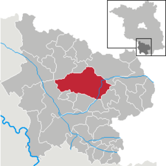 | |
Ortsteile | |
| Government | |
| • Mayor (2017–25) | Bodo Broszinski[1] (FDP) |
| Area | |
| • Total | 148.93 km2 (57.50 sq mi) |
| Elevation | 97 m (318 ft) |
| Population (2022-12-31)[2] | |
| • Total | 9,032 |
| • Density | 61/km2 (160/sq mi) |
| Time zone | UTC+01:00 (CET) |
| • Summer (DST) | UTC+02:00 (CEST) |
| Postal codes | 03253 |
| Dialling codes | 035322 |
| Vehicle registration | EE, FI, LIB |
| Website | www.doberlug-kirchhain.de |
Doberlug-Kirchhain (Lower Sorbian: Dobrjoług-Góstkow) is a German town in the district of Elbe-Elster, Lower Lusatia, Brandenburg.
History
937. The town of Kirchhain was built by Margrave Gero. A document written in 1005 mentions the town Doberlug (Dobraluh) for the first time. In 1165 the Cistercian Dobrilugk Abbey was founded by Margrave Dietrich of Landsberg.
1235. Kirchhain received market-rights. In 1431 the
From 1815 to 1947, Doberlug and Kirchhain were part of the Prussian Province of Brandenburg.
1848. The jurisdictions of Doberlug and Kirchhain were unified, but the actual merger of the two towns did not take place until over one hundred years later, in 1950.
During World War II, Kirchhain was taken by the Red Army on 23 April 1945.
From 1952 to 1990, Doberlug-Kirchhain was part of the Bezirk Cottbus of East Germany.
On August 28, 1992, the
Demography
-
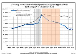 Development of Population since 1875 within the Current Boundaries (Blue Line: Population; Dotted Line: Comparison to Population Development of Brandenburg state; Grey Background: Time of Nazi rule; Red Background: Time of Communist rule)
 -
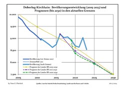 Recent Population Development and Projections (Population Development before Census 2011 (blue line); Recent Population Development according to the Census in Germany in 2011 (blue bordered line); Official projections for 2005-2030 (yellow line); for 2017-2030 (scarlet line); for 2020-2030 (green line)


|
|
|
Climate
| Climate data for Doberlug-Kirchhain | |||||||||||||
|---|---|---|---|---|---|---|---|---|---|---|---|---|---|
| Month | Jan | Feb | Mar | Apr | May | Jun | Jul | Aug | Sep | Oct | Nov | Dec | Year |
| Mean daily maximum °C (°F) | 3.4 (38.1) |
5.0 (41.0) |
9.2 (48.6) |
15.3 (59.5) |
19.7 (67.5) |
23.1 (73.6) |
25.3 (77.5) |
25.1 (77.2) |
20.1 (68.2) |
14.3 (57.7) |
8.1 (46.6) |
4.4 (39.9) |
14.4 (57.9) |
| Daily mean °C (°F) | 0.6 (33.1) |
1.5 (34.7) |
4.6 (40.3) |
9.5 (49.1) |
13.9 (57.0) |
17.3 (63.1) |
19.4 (66.9) |
19.0 (66.2) |
14.5 (58.1) |
9.6 (49.3) |
4.9 (40.8) |
1.8 (35.2) |
9.7 (49.5) |
| Mean daily minimum °C (°F) | −2.4 (27.7) |
−2.0 (28.4) |
0.3 (32.5) |
3.3 (37.9) |
7.5 (45.5) |
11.0 (51.8) |
13.2 (55.8) |
12.8 (55.0) |
9.2 (48.6) |
5.4 (41.7) |
1.7 (35.1) |
−0.9 (30.4) |
4.9 (40.8) |
| Average precipitation mm (inches) | 45.7 (1.80) |
34.0 (1.34) |
38.8 (1.53) |
27.9 (1.10) |
57.2 (2.25) |
53.4 (2.10) |
69.4 (2.73) |
61.2 (2.41) |
45.8 (1.80) |
39.4 (1.55) |
43.3 (1.70) |
44.1 (1.74) |
561.6 (22.11) |
| Average precipitation days (≥ 0.1 mm) | 17.1 | 13.7 | 15.1 | 11.0 | 13.1 | 12.9 | 14.0 | 12.7 | 11.8 | 13.8 | 15.0 | 16.4 | 166.8 |
| Average relative humidity (%)
|
84.5 | 80.6 | 77.0 | 70.5 | 70.5 | 70.0 | 69.0 | 69.9 | 76.6 | 82.3 | 87.1 | 86.2 | 77.8 |
| Mean monthly sunshine hours | 55.2 | 78.0 | 124.7 | 190.8 | 224.2 | 218.7 | 228.4 | 220.4 | 163.7 | 114.1 | 62.2 | 48.3 | 1,741.3 |
| Source: NOAA[4]
| |||||||||||||
Coat of arms
The coat of arms of the town shows the town hall with three towers topped with yellow flags. Below is a green ring. On top are two clouds and rays of the sun. The shield is blue, and shaped like a leather sheet, symbolizing the history of the city as a tannery center. The coat of arms was created in 1950 by combining the symbols of the coats of arms of Doberlug and Kirchhain: the green ring and the sun are taken from the arms of Doberlug, while the town hall is from those of Kirchhain.
Twin towns
Doberlug-Kirchhain is twinned with Hemer in North Rhine-Westphalia and Kirchhain in Hesse.
Notable natives and residents
Kirchhain
- Daniel Schade (1601–1662), Musician
- Karl Gustav von Berneck (1803–1871), writer
- Guido Jendritzko (born 1925), sculptor and painter
- Catrin Große(born 1964 in Finsterwalde), painter, graphic designer and sculptor
Doberlug
- Heinrich Clauren (1771–1854), also Carl Gottlieb Samuel Heun, writer
- theologist
- Hermann Wilhelm Vogel (1834–1898), chemist
- Eduard Köllner, (1839–1891), composer of Festhymne zur 100 jährigen Jubelfeier der Unabhängigkeitserklärung der Vereinigten Staaten Nordamerikas (Hymn for the Independence Day 1876)
Photogallery
-
 The town in the Kreis Elbe-Elster
 -
 Church Gate of Dobrilugk Abbey
 -
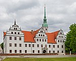 Castle of Doberlug in May 2015


References
- ^ Landkreis Elbe-Elster Wahl der Bürgermeisterin / des Bürgermeisters, accessed 1 July 2021.
- Amt für Statistik Berlin-Brandenburg(in German). June 2023.
- ^ Detailed data sources are to be found in the Wikimedia Commons.Population Projection Brandenburg at Wikimedia Commons
- ^ "Doberlug-Kirchhain Climate Normals 1991–2020". National Oceanic and Atmospheric Administration. Archived from the original on 16 September 2023. Retrieved 16 September 2023.
External links
![]() Media related to Doberlug-Kirchhain at Wikimedia Commons
Media related to Doberlug-Kirchhain at Wikimedia Commons
Towns and municipalities in Elbe-Elster | ||
|---|---|---|
|  | |
| International | |
|---|---|
| National | |