
Plessa
Plessa | |
|---|---|
 | |
 Coat of arms | |
Location of Plessa within Elbe-Elster district  | |
Ortsteile | |
| Government | |
| • Mayor (2019–24) | Gottfried Heinicke[1] (CDU) |
| Area | |
| • Total | 52.42 km2 (20.24 sq mi) |
| Elevation | 94 m (308 ft) |
| Population (2022-12-31)[2] | |
| • Total | 2,564 |
| • Density | 49/km2 (130/sq mi) |
| Time zone | UTC+01:00 (CET) |
| • Summer (DST) | UTC+02:00 (CEST) |
| Postal codes | 04928 |
| Dialling codes | 03533 |
| Vehicle registration | EE, FI, LIB |
| Website | www.plessa.de |
Plessa (Lower Sorbian: Plesow, pronounced [ˈplɛsɔw]) is a municipality in the Elbe-Elster district, in Brandenburg, Germany.
Following a redrawing of local boundaries which took effect on 31 December 2001, the municipality includes two additional settlements, and therefore now includes Plessa-Süd, Döllingen and Kahla.[3]
History
The first surviving record of Plessa appears in the 1406 "Landbethe zu Hayn",[4] where a total area of slightly more than 24 Oxgangs is recorded. The name "Ples(o)" comes from an old Sorbian word for a lake, and probably refers to backwaters of the Black Elster River, now to an extent channelled, but which in the fifteenth century, with numerous small tributaries meandered through the area.[5] Taxes were paid to the Elsterwerda Castle, home to the lords who owned the land.[5]
The earliest record of a simple unadorned wooden chapel appears in 1540, at this stage without any cross or candle sticks for the altar. Preaching at this time would still have taken place in Sorbian. In 1792 a stone church was built, but on 25 October 1811 the village, still mostly comprising timber buildings, was struck by a major fire which only four farmsteads survived. Beside the church the adjacent school house was also badly damaged. The present church was erected in 1814, with an organ installed in 1818.[4][5]
From 1816 to 1944, Plessa was part of the
The
After the war the briquette factory and other industrial businesses were nationalised in 1950, shortly after the formal establishment of the
From 1952 to 1990, Plessa was part of the Bezirk Cottbus of East Germany. On 1 January 1957 Plessa-Süd (previously known as Grödener Schraden) was incorporated into Plessa.[5]
A serious accident took place in 1983 at the Plessa Briquette factory when a coal gas explosion caused several deaths and left many injured.
Local government reorganization followed two years after reunification in 1992, and Plessa became the centre of the Plessa collective municipality, incorporating seven individually small municipalities. In 1998 the power station became a project of the "Fürst-Pückler-Land" regional redevelopment programme.
Demography

|
|
|
Photogallery
-
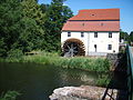 Elster mill in Plessa
 -
 Bertzit Tower in Kahla
 -
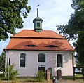 Church in Döllingen


References
- ^ Landkreis Elbe-Elster Wahl der Bürgermeisterin / des Bürgermeisters, accessed 1 July 2021.
- Amt für Statistik Berlin-Brandenburg(in German). June 2023.
- Statistisches Bundesamt
- ^ a b Amt Plessa - Eine Region in der reizvollen Niederlausitzer Heidelandschaft (Euroverlag ed.). Cottbus: Amt Plessa. 1996.
- ^ ISBN 3-412-10900-2.
- ^ Der Russe kommt. „Kulturzeit extra: Plessa. Partisanendorf“ Archived 2013-07-12 at the Wayback Machine, a 3sat documentation, August 2009 (in German).
- ISBN 3-00-008956-X.
- ^ Detailed data sources are to be found in the Wikimedia Commons.Population Projection Brandenburg at Wikimedia Commons
Towns and municipalities in Elbe-Elster | ||
|---|---|---|
|  | |
| International | |
|---|---|
| National | |