
Downtown Minot
Downtown Minot | |
|---|---|
 Downtown Minot from Third Street NE | |
| Coordinates: 48°14′06″N 101°17′35″W / 48.235°N 101.293°W | |
| Country | |
| State | |
| County | Ward County |
| City | Minot |
| Subdistricts of downtown | |
| Government | |
| • Minot City Council | Larry Frey, David Lehner, Bob Miller, George Withus, Kevin Connole, Lisa Olson |
| • State Assembly | Andrew G. Maragos (R), Roscoe Streyle (R), Scott Louser (R), Roger Braband (R) |
| • State Senate | Randall A. Burckhard (R), Oley Larsen (R) |
| • U.S. House | Kevin Cramer (R) |
| Area | |
| • Total | .24 sq mi (.62 km2) |
| Highest elevation | 1,665 ft (507 m) |
| Lowest elevation | 1,552 ft (473 m) |
| ZIP Codes | 58701, 58703 |
| Area code | 701 |
| Website | downtownminot.com |
Downtown Minot is the
Geography
History

In 1808, Alexander Henry The Younger identified the Assiniboine living along the Souris Valley as the Little Girl band.[9] The Little Girl band or Souris River Assiniboine were the southernmost tribe of the Assiniboine[10] The region they inhabited later became part of Rupert's Land, part of Hudson's Bay Company claim.[11] This land did not become part of the United States until fifteen years after the Louisiana Purchase, at the London Convention. Minot was first settled in 1886, when the Great Northern Railway was extended to that location. Originally, a tent city sprung up where the trestle was being constructed across the Gassman Coulee.[12] When it became known that the railroad had picked a townsite to the east, the tent city was relocated to what is now downtown Minot. At this time, the area was part of the Dakota Territory, whose capital had been transferred from Yankton in what is now South Dakota, to nearby Bismarck in 1883.[13]
Olfa Olson, Ole Spokle, Ed Kettleson and

People collected buffalo bones from the surrounding area and brought them to the railroad track downtown. The bones were used for fertilizer and in the process of refining sugar. Piles of bones were stacked along the railway. In 1888, the pile along the railroad tracks extending east from Main Street was so large that the railroad built a spur track to load cars.[19] Lignite mining was another earlier industry that was established around Minot.[20]
On July 16, 1887, the village of Minot was incorporated and James H. Scofield became the first mayor. The second mayor of Minot, elected the following year, was the city's first physician, Dr. Edmund Belvea. Minot's population at this time was already around four hundred. By 1890, Minot's population was nearly thirteen hundred. Minot's early population growth earned it its nickname "The Magic City".[21] By the 1910 census, Minot had outgrown Bismarck, to become the third largest city in the state. By 1970, however, Bismarck had regained that position.[22][23] The Minneapolis, St. Paul and Sault Ste. Marie Railway, nicknamed the Soo Line for Sault Ste. Marie's pronunciation,[24] was the second railroad to reach Minot, in 1893.[25] The Soo Line Passenger Depot, built in 1912, served this line.[26] In 1887, the city began publishing its first newspaper, the Minot Rustler Tribune.[27] In the early 1920s, bank robbers, "Smiling" Johnny Reid and "Chicago Freddie"[28] were living in Minot.[29][30] Johnny Reid was one of several aliases used by Leslie Ayer, born in Prince Rupert, British Columbia in 1895. "Chicago Freddie", along with Arthur Schultz and George Long, were aliases of Arthur G. Davis, an American bank robber. Davis had just been released on parole, when he met Ayer in Minot in 1921. The pair stole more than $2 million from banks in Canada and the United States in the early 1920s.
In 2011, the Souris River flood inundated much of the river valley in Saskatchewan, North Dakota and Manitoba. In Minot, about a quarter of residents of the city were evacuated.[31] On June 24, the Souris River surpassed previous crest heights[32] This was considered a five-hundred year flood event. Hesco barriers were installed by the National Guard downtown before the flooding began.[33] The secondary dikes and Hesco barriers helped to limit some of the flooding downtown. The flooding downtown was primarily in the northern section of the East End/Bayou section up to Central Avenue.[34]
Economy
Top employers
The top employers in Downtown Minot, according to the Minot Area Development Corporation in the first quarter of 2013 are:[35]
| # | Employer | # of Employees |
|---|---|---|
| 1 | Trinity Health | 2,593 |
| 2 | Minot Public Schools | 1,545 |
| 3 | City of Minot | 323 |
| 4 | Ward County | 230 |
| 5 | US Post Office | 105 |
| 6 | Minot Daily News | 85 (2011)[36] |
Neighborhoods
Commercial Historic District
East End/Bayou

The East End/Bayou District is a neighborhood adjacent to the Commercial Historic District, not officially recognized as part of the Central Business District.[37][38] It is situated within the Minot Industrial Historic District.[39] The East End/Bayou neighborhood borders the Coney Island Addition to the north, the Woodland Addition and the river to the east, CP's railroad tracks to the south and the Commercial Historic District to the west.[38] It is a mixed-use neighborhood, zoned mostly industrial and commercial.[40] It has a similar building density to the rest of downtown. Central Avenue and Third Street East are the main thoroughfares through the neighborhood. The neighborhood is home to many businesses, including two bicycle shops, a flower shop and also the Railroad Museum. Bricks on Central, a three-story brick building, converted for office and commercial space, is home to a patisserie, a nursery, two photography studios, a dance studio, a fitness center and a software developer.[41] The First Avenue Pedestrian Bridge connects the neighborhood with the Torbenson neighborhood on the north side of the river. The Sixth Street Pedestrian Bridge connects the neighborhood with Eastwood Park. The two neighborhoods are separated by the Eastwood Oxbow, for which the Bayou Addition received its name.[38]
Government Center
Government Center is the small area formed from the triangle created by the Burdick Expressway, Third Street SE and Front Street. It is not considered part of the Central Business District. Government Center is home to the Ward County Courthouse, the county library and the county jail. It is the future location of the Ward County Office Building, a planned three-story, sandstone and glass office building across from the courthouse. The Minot Daily News building is also located in the neighborhood.
High Third
High Third was Minot's tenderloin or
Lower Brooklyn
The lower part of the Brooklyn neighborhood is included in Minot's Central Business District. Brooklyn, named for the Brooklyn Addition, is bounded by Sixth Street SW, Eleventh Avenue SW, Broadway and the Burdick Expressway.[38][45] Lower Brooklyn is the northeast section of the neighborhood bounded by a line continued from Fourth Street SW and Eighth Avenue SW. Upper Brooklyn or Brooklyn Heights is the southwestern portions of the neighborhood on South Hill and is not considered part of downtown. The Brooklyn Heights Apartments are named after the neighborhood.[46] Upper Brooklyn is also home the Scandinavian Heritage Park. Lower Brooklyn is home to a few businesses, residences and a car dealership.
Cityscape

The Blakey Block is located at 107 Main Street. The building was designed by Robert Stacy-Judd, who lived in Minot and operated a firm in town from 1917 to 1919.[47] The Blakey Block was formerly home of A.S. Blakey Drugs. In the first half of the twentieth century, it was also home to the short-lived Minot College of Commerce, which was located on the second floor.[48] Today, the building is home to a jewelry store. It is pictured in the postcard above, just past the Cafe sign on the left hand side of the road.
Bricks on Central is a three-story brick building in the Bayou section, which has been converted for commercial use.
The Carnegie Library is located on 2nd Avenue SE and was built in 1911. The Classical Revival style building served as the city's library from 1912 until 1965. The building now called the Carnegie Center is used for special events.
The Fair is the second location of the Ellison brothers Fair department store. Engel, Norman and Otto Ellison opened the new location in 1910.[49] In 1929, a second building, just south of the Fair Block was opened at the corner of Second Avenue and Main Street. The building at the corner of Second Avenue and Main Street was intended to be five stories, four stories for the store and the top stories for offices. The building, however, was only built as a three-story structure. Today the building is home to offices, restaurants and stores. The upper floors are home to apartment and condominiums.
The First Avenue Building at 13 First Avenue SW is a five-story building between West Alley and First Street SW. The building was completed in 1928 and is concrete with an applied masonry facade.[50] The building used to face Minot's first city hall built in 1905. That building was later razed to build a parking lot. The site is expected to become the location of a public parking garage in 2013.
Fountain Plaza located at the Southwest Corner of First Avenue and Main Street. It is named for the fountain, originally located in the middle of Main Street, which has since been moved to this location. The Lyceum Theater operated at this site, in an earlier building, in the early twentieth century. In the 1920s, the theater was renamed the Strand Theater and in 1955 it became the Town Theater. The theater building was torn down in the 1960s.[51]
The Lee Block or Evergreen Square is the building on the southwest corner of Main Street and Central Avenue.
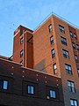
The Minot Building, also known as the Midwest Federal Building, is located on Second Avenue SW between 1st Street and West Alley. The building formerly served as the Minot Federal Savings and Loans headquarters.[53] The dark eight-story building and the large letter M, make the building a landmark in downtown.
The Minot Public Library, located on Second Avenue SW, has served as the public library for the city, since the building was dedicated in 1966.
The Parker Suites at 19 First Avenue SE were built between 1929 and 1943. George Vaulker commissioned the project as an office building, but only the bottom two floors were finished for many years. As historical pictures show, the supports for the upper floors were built, but the building remained unfinished. Clarance Parker bought and finished construction of the building turning it into a hotel. President Eisenhower stayed at the hotel in 1953, while visiting the recently completed Garrison Dam.
The Scofield Block is the building on the east side of Main Street, just south of Artspace Lofts. The building is named for
The Soo Line Passenger Depot is an old railroad station built in 1912 at the northern end of Main Street. The depot, no longer located on a line which offers passenger service, has since been converted to the Old Soo Depot Transportation Museum.
The Tompkins Block is located between 10 North Main and the Taube Art Museum on the east side of North Main Street. The two-story building is named after the former mayor of Minot,
Attractions
Arts and culture
- Arlene Theater, a theater hosting performances by a community theater group called the Mouse River Players is located on First Avenue SE.
- Minot Public Library, the city's public library located on the west end of downtown on Second Avenue SW.
- Taube Museum of Art, an art museum which first opened in 1970, is located in the Union National Bank Building on North Main Street.
- Old Soo Transportation Museum, located in the old Soo Line Depot, built in 1912, has items related to Minot's railroad history.
- Railroad Museum of Minot, a museum displaying artifacts from Minot's railroad history, is located on First Ave NE
- 62 Doors Gallery and Studios, is an art gallery and studio space so named for the walls in the studios constructed from salvaged doors
- Margie's Art Glass Studio, is a studio space and gift shop, selling art glass supplies and handmade glasswork.
- Pangea House, a community center with a focus on music and art, which also hosts Why Not Fest, an annual music and arts festival.
- Ward County Library, a small library in Government Center open on weekdays only.
Sports venues
The Minot Municipal Auditorium is a 5,000-seat multi-purpose venue at the western edge of downtown. Despite having a larger seating capacity than All Seasons Arena, two miles to the east or Maysa Arena, two miles to the southwest, the Municipal Auditorium has no current tenants. The Minot Minotauros of the North American Hockey League play their games at Maysa Arena. The MSU Beavers hockey team plays their games at All Seasons Arena. The Minot SkyRockets, a former Continental Basketball Association team played their games at the Municipal Auditorium. The Auditorium has recently served as a venue for concerts. In the fall of 2011, students at Ramstad Middle School began attending classes at the Minot Municipal Auditorium downtown.[55] Temporary classroom units on the property were also needed to accommodate students. A new Ramstad Middle School is currently being constructed on North Hill, which is expected to open for the 2013-2014 school year.
Places of worship
- Catholic
Grace Communion International meets at the Central High School Campus
Tallest buildings
There is currently a maximum height limit of one hundred and fifty feet for the Central Business District.[56] There is no height limitation for most of the East End/Bayou neighborhood.[40]
| Rank | Building | Height | Floors | Year completed/projected | Status |
|---|---|---|---|---|---|
| 1st | Milton Young Towers | 151.93 ft (46 m) | 14 | 1972 | Completed |
| 2nd | The Minot Building | 112.62 ft ft (34 m) | 8 | 1962 | Completed |
| 3rd | The Parker Suites | 97.66 ft ft (30 m) | 9 | 1946 | Completed |
-
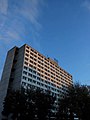 Milton Young Towers
 -
 The Minot Building
 -
 Parker Suites


Demographics
Approximately 65% of the residents of downtown Minot were born in North Dakota. 28.4% of the population was born in other US states and 6.6% of the population was born outside of the United States.
Government Facilities

Government Center, the triangle formed from the Burdick Expressway, Third Street SE and Front Street is home to a number of Ward County facilities. This area is home to the county courthouse, the county jail and the county library. The Minot Public Library is located on the western edge of the downtown neighborhood, on the corner of Second Ave SW and Sixth Street SW. The former public library, the Minot Carnegie Library is located on Second Avenue SE. The former library, now called the Carnegie Center, hosts numerous special events throughout the year. There are also current plans to construct a county office building in the neighborhood. The neighborhood is also home to the Minot Daily News, the primary print newspaper for the northwestern part of the state. The first Ward County Courthouse was located in Burlington. It was built in 1886 and at that time the county was called Imperial Ward County and included parts of Burke, Mountrail and Renville counties. This building is now located at the North Dakota State Fairgrounds in Minot. The building sustained some minor damage from the Souris River flood in 2011. In 1889, a new county courthouse was built at the present site on Third Street. The brick building was raised in 1928, so a new courthouse could be constructed on the site.[57] In 1929, the current Art Deco Ward County Courthouse, designed by the architectural firm Toltz, King & Day, was constructed on the same site. The county jail is situated just to the east of the courthouse. The planned county office building would be constructed, just to the north of the courthouse on the other side of Third Avenue.
The
Minot's first city hall was located on First Avenue Southwest on West Alley between First Street SW and Main Street. The two-story brick building remained in use as Minot City Hall for fifty years.[59] Today, Minot City Hall is located in a complex with the police station on Second Avenue across from the city library.
Education
The University of North Dakota's School of Medicine and Health Sciences has a Northwest Campus located downtown. The campus is host to a small number of medical students and family medicine residents at Trinity Hospital.[60] The campus is also home to the Angus L. Cameron Medical Library. The library is open on weekdays and provides resources and services to medical staff at Trinity and to students. Limited resources and services are also available to the general public.[61]
Downtown is also home to Minot High School's Central Campus and Central Campus East. Central Campus East is an alternative campus for students under 16. The Central Campus is the high school in Minot for ninth and tenth graders. It is located in the expanded former Minot High School building, which was constructed in 1918.[62] In 1974, a new high school was opened in Minot, west of downtown. That campus has since become the Magic City Campus and is for eleventh and twelfth graders.
The former Minot Armory building is now home to the Minot School District offices. In 1913, the armory housed Minot State Normal School's first library.[63]
Transportation

The main roads accessing downtown are the Burdick Expressway and Broadway. The Burdick Expressway is a four lane road, which carries Business US 52 and Business US 2 through downtown. Broadway carries US 83 through downtown. The Minot Bypass, a loop composed of alternate routes for all three roads travels around the city. The southern segment of the bypass is a four-lane limited-access highway, while the Western Bypass is a two-lane limited-access highway. A recently constructed Northeast Bypass carries traffic from US 2 on the east side of town to US 83 north.
Downtown in one and a half miles from
Amtrak

Although the Soo Line Depot downtown is no longer used as a passenger station, Amtrak's
Local Service

Taxi-9000 and the Central Cab Company are two cab companies that operate in Minot. Two rental companies in Minot, Enterprise and Rent-a-Wreck, offer pickup service to their customers. Minot City Transit operates several bus routes, which serve downtown on weekdays. Cash fare or tokens can be purchased upon boarding the bus. In the mornings, bus routes from downtown service Minot State University and West Minot on the North Central Route, Minot State University and North Hill from the North Route, Eastwood Park and Holiday Village from the East Route, South Hill and the Dakota Square Mall form the South #2 Route and Oak Park and Bel Air from the West Route. In the afternoon, North Hill can be accessed from the North Route, Roosevelt Park and Holiday Village from the East Route, South Hill from the South Route #1 and Minot State University and Oak Park from the West Route.[68] The City of Minot is currently conducting a transit study to determine the transit service needs of the city and the region over the next five to ten years.[69]
On January 8, 1912, former
Regional Service
Souris Basin Transportation offers service from Minot to Crosby, Kenmare, the Minot Air Force Base and Sawyer.[71] The Dakota Shuttle offers daily service to Stanley, Tioga and Williston.[72] The pickup location can be reached from downtown via city cab or the North bus line. There is a bus from Minot to Bismarck that leaves at 1:00 PM on every day except Thursday and Saturday, which returns at 4:30 PM. The bus stops at Washburn at 2:15 PM on the way to Bismarck and at 5:25 PM on the way to Minot.[73]
Future development

The downtown neighborhood was part of a redevelopment project. The $140 million Imagine Downtown project helped restore the downtown district in response to the 2011 Flood.
The Artspace Minot Lofts, a new addition to Main Street, is a four-story 34-unit residential building on the site of the former Leland Parker Hotel. The building was the first building constructed downtown in thirty years.[78] In addition to the residential space, commercial arts-related space is available.[79] One tenant of this space is a Native American museum and gift shop.[80]
A new Ward County Office Building downtown was designed by JLG Architects[81] The project included the expansion of the Ward County Jail. The new office building matches the look of the Ward County Courthouse, but has a glass entryway. The architect explained that the current design allows for future vertical expansion.
Events
Downtown Minot host numerous events throughout the year, which include:
- Hot Summer Nights Wine Walk in June
- Festival on Main, held in August
- Why Not?!? Minot Music and Arts Festival (formerly "Why Not Fest"), held in August
- The Wine Walk, held in September
- The Souris Valley Garlic and Grape Festival, held in September
- Artfest, held in October
- Worldwide Photo Walk, held in October
- Tree Lighting Ceremony, held in November
- Small Business Saturday, held the day after Black Friday
- Christmas Open House, held in November
Emergency Services
Hospitals
Trinity Hospital is located along the Burdick Expressway in downtown.
Trinity Hospital is no longer located along Burdick expressway downtown. Location has moved to 2305 37th ave SW, Minot ND 58701
Fire services
The Minot Fire Department operates Fire Station #2 in Downtown[82]
Police services
The Minot Police Department operates just outside the Central Business District at 515 Second Ave SW.
Gallery
-

-

-
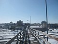 Anne Street Bridge
 -
 Carnegie Center
 -
 Armory


References
- ^ Federal Writers' Project. "North Dakota: A Guide to the Northern Prairie State." US History Publishers, 1950.
- ^ Downtown Minot Business Members Archived December 8, 2012, at the Wayback Machine
- ^ Minot City Map Archived October 30, 2012, at the Wayback Machine
- ^ Minot Central Business District Map Archived March 4, 2014, at the Wayback Machine, accessed from the City of Minot's website February 5, 2013
- ^ Anne Street Viaduct, Minot
- ^ Bridge Hunter, First Avenue Bridge
- ^ Torbenson Addition
- ^ Bridgehunter: Eastwood Park Bridge
- ^ Miller, David, et al. "The History of the Assiniboine and Sioux Tribes of the Fort Peck Indian Indian Reservation, Montana, 1800-2000". Montana Historical Society, 2008.
- ^ Ray, Arthur J. "Indians in the Fur Trade: Their Role as Trappers, Hunters, and Middlemen in the Lands Southwest of Hudson Bay: 1660-1870" Toronto: University of Toronto Press, 1998.
- ^ Rees, Tony. "Arc of the Medicine Line: Mapping the World's Longest Undefended Border Across the Western Plains" U of Nebraska Press, 2007
- ^ Workers of the Federal Writers' Project of the Works Progress Administration for the State of North Dakota. North Dakota: A Guide to the Northern Prairie State. Fargo: Knight Printing Company, 1938.
- ^ Grow, Kathy K. and Lois H. Varvel. "Yankton, South Dakota: In Vintage Postcards". Arcadia Publishing, 2004
- ^ "North Dakota Year Book". North Dakota Magazine. 1910-1911. Agricultural Department, 1911.
- ^ St. Paul, Minneapolis & Manitoba Railway Company. "The Mouse River North Dakota". Princeton University.
- ^ Gittelman, Steven H. "J.P. Morgan and the Transportation Kings: The Titanic and Other Disasters." University Press of America, 2012.
- ^ Brown, Galen. Exploring Minot 1885-1900
- ^ Brown, Galen. "Exploring Minot: 1885-1900." Minot State University
- ^ a b Gavett, Joseph L. "Minot: The Magic City". Chicago: Watchmaker Publishing, Ltd, 2006.
- ^ USGS "Bulletin, Issue 906." U.S. Government Printing Office, 1941.
- ^ Olstad, Geneva Roth. "Main Street, North Dakota." Arcadia Publishing, 2000.
- ^ Minot Community Data Archived January 13, 2013, at the Wayback Machine
- ^ Bismarck Population
- ^ Yenne, Bill. "Atlas of North American Railroads." Voyageur Press, 2005.
- ^ Maiken, Peter T. "Night Trains: The Pullman System in the Golden Years of American Rail Travel." Lakme Press, 1989.
- ^ Editors of Trains magazine. "Tourist Trains Guidebook." Kalmbach Publishing Co., 2009.
- ^ Meyer, Herbert W. "Builders of Northern States Power Company." Northern States Power Company, 1957.
- ^ "Notorious as Crook: Yeggman to Be Returned to Montana for Trial With Seven Others". The Spokesman-Review. December 13, 1923.
- ^ Butts, Edward. The Desperate Ones: Forgotten Canadian Outlaws. Toronto: Dundurn Press, 2006
- ^ "Sentence Suspended: 'Smiling' Johnny Reid Convicted in Vancouver". The Montreal Gazette. May 21, 1924.
- ^ Fundingsland, Kim. "EVACUATED! Resident Flee Rising Souris; Burlington Braces for Des Lacs Blast." Minot Daily News. June 1, 2011.
- ^ Davidian, Geoff. "Souris River Crests in Flooded Minot, North Dakota." Reuters. June 26, 2011.
- ^ "National Guard Begins Minot Recovery Effort". Archived from the original on May 22, 2013. Retrieved February 25, 2013.
- ^ Satellite Image Minot Flood
- ^ "Minot's Top Employers 1st Quarter, 2013" (PDF). 2013. Archived from the original (PDF) on March 4, 2016. Retrieved March 20, 2013.
- ^ "Minot's Top Employers 3rd Quarter, 2011" (PDF). 2011. Archived from the original (PDF) on March 4, 2016. Retrieved March 5, 2013.
- ^ Minot Central Business District Map Archived March 4, 2014, at the Wayback Machine
- ^ a b c d 1915 standard atlas of Ward County, North Dakota, plat book and patron's directory Geo. A. Ogle & Co., 1915
- ^ Mark T. Fiege; Mary E. McCormick; Fredric L. Quivik (July 1986). "National Register of Historic Places Registration: Minot Industrial Historic District". National Park Service. and accompanying photos
- ^ a b "Minot Zoning Map" (PDF). Archived from the original (PDF) on January 5, 2012. Retrieved February 24, 2013.
- ^ Bricks on Central
- ^ Smith, Gary. "Hello, Trouble, I'm Dale Brown". Sports Illustrated. November 18, 1985
- ^ a b c "South Dakota Review, Volume 28" The University of South Dakota, 1990
- ^ "Call Threaten Chief, Manager at Minot, N.D." Ellensburg Daily Record November 27, 1954.
- ^ DeGraw Peter Voorhees. Street Directory of the Principal Cities of the United States: Embracing Letter-Carrier Offices Established to April 30, 1908. The Manhattan Press, 1908
- ^ Brooklyn Heights Apartments
- ^ Lounsberry, Clement Augustus. North Dakota History and People: Outlines of American History, Volume 3. S.J. Clarke Publishing Company, 1917.
- ^ State Historical Society of North Dakota Digital Viewer
- ^ The Fair Digital Minot
- ^ 13-15 First Ave SW Emporis
- ^ .Lyceum Theater, 1909. Digital Minot: An Online Museum of Local History
- ^ Lee Block
- ^ MINOT FEDERAL SAVINGS & LOAN ASSN., Appellee, v. UNITED STATES of America, Appellant.
- ^ Hennessy, William B. History of North Dakota, Embracing a Relation of the History of the State from the Earliest Times Down to the Present Day, Including the Biographies of the Builders of the Commonwealth. Bismarck: Bismarck Tribune Company, 1910.
- ^ "The Flood and the Future of Ramstad". Archived from the original on April 9, 2013. Retrieved April 4, 2013.
- ^ Minot Zoning Plan Archived January 5, 2012, at the Wayback Machine
- ^ "Ward County Jail and Courthouse, Minot, N.D."
- ^ Judge Van Sickle Federal Building and U.S. Courthouse
- ^ Gavett, Joseph L. Minot: The Magic City. Watchmaker Publishing, 2006.
- ^ UND School of Medicine NW Campus
- ^ Angus L. Cameron Medical Library Archived May 23, 2013, at the Wayback Machine
- ^ Minot History Archived 2013-01-16 at the Wayback Machine
- ^ "Gordon B. Olson Library History". Archived from the original on December 13, 2013. Retrieved February 22, 2013.
- ^ "Airport Numbers Soar to Record in 2012" KXNews. http://www.kxnet.com/story/20538062/airport-numbers-soar-to-record-in-2012 January 8, 2013.
- ^ Amtrak Fact Sheet, Fiscal Year 2012 State of North Dakota
- ^ BNSF Subdivision Map Archived 2013-03-13 at the Wayback Machine, accessed February 5, 2013
- ^ Current Time in North Dakota by County, accessed February 5, 2013
- ^ Minot City Transit Archived 2013-08-15 at the Wayback Machine, accessed February 5, 2013
- ^ Minot Comprehensive System Analysis
- ^ "Minot's birthday approaching" Minot Daily News. January 30, 2011
- ^ Souris Basin Transportation
- ^ Dakota Shuttle
- ^ Greyhound schedules carrier BLE
- ^ "Hoeven: $18 Million in Disaster Recovery Grant Request for Minot's Downtown Reconstruction Project Approved by EDA Investment Review Committee" http://www.hoeven.senate.gov/public/index.cfm/news-releases?ID=37540763-9903-444c-b1b7-784c325fdeb8 accessed February 5, 2013
- ^ Schramm, Jill. "Council Approves MAGIC Fund grant for parking ramps". Minot Daily News. November 6, 2012.
- ^ Wells Fargo Location Minot
- ^ US Bank Location Minot
- ^ Minot Artspace Lofts
- ^ Artspace Minot "Artspace :: Artspace Minot". Archived from the original on June 24, 2011. Retrieved February 5, 2013. accessed February 5, 2013
- ^ "PROJECT ANNOUNCEMENT: Loeffler Construction Selected to Build Magic City Artspace Lofts" Loeffler Construction and Consulting http://www.loefflerconstruction.com/_blog/News/post/PROJECT_ANNOUNCEMENT_Loeffler_Construction_Selected_to_Build_Magic_City_Artspace_Lofts/ accessed February 5, 2013
- ^ McColgan, Flint. "New county office building design unveiled". Minot Daily News February 21, 2013.
- ^ Minot Fire Department Archived May 14, 2015, at the Wayback Machine