
E3 European long distance path

The E3 European long distance path, or just E3 path, is a 6,950-kilometre (4,320 mi) long-distance footpath that is planned to run from the Portuguese coast to the Black Sea in Bulgaria. It is one of the network of European long-distance paths.
Route
The completed sections of the route pass through Spain, France, Luxembourg, Belgium, Germany, the Czech Republic, Slovakia, a short stretch in Poland, Hungary, Romania, and Bulgaria.
It is planned to extend the route into Portugal to end at Cape St. Vincent.
Gallery
-
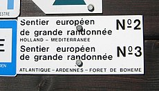 Sign on the path of the E3 near Vianden, Luxembourg.
 -
 E3 as a part of the standard blue-marked path near Karlovy Vary, Czech Republic.
 -
 E3 at the west end of the Malá Fatra mountain range in northern Slovakia. The E3, E8, and other long-distance footpaths are marked in red on the Slovakia 1:50,000 "Turistika Mapa" / "Hiking maps".
 -
 The E3 in spring 2005 on the lightly-snowing Malá Fatra ("Lesser Fatra" mountains, the west end of the Carpathian mountains) in northern Slovakia. The E3 is well marked also on the maps of Slovakia and the Czech Republic.
 -
 Markers used on the Bulgarian part of the route.
 -
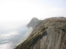 The E3 ends at Cape Emine.


External links
This article's use of external links may not follow Wikipedia's policies or guidelines. (February 2024) |
- E3 - map and information at European Ramblers' Association
- Digitalized Slovak part of E3, GPX download included
- Info about the Bulgarian part of E3
This trail or long-distance path-related article is a stub. You can help Wikipedia by expanding it. |