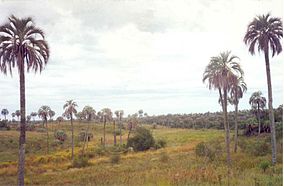
El Palmar National Park
| El Palmar National Park | |
|---|---|
 | |
| Location | Entre Ríos Province, Argentina |
| Nearest city | Colón |
| Coordinates | 31°51′11″S 58°19′21″W / 31.85306°S 58.32250°W |
| Area | 85 km2 (33 sq mi) |
| Established | 1966 |
| Governing body | Administración de Parques Nacionales |
| Official name | Palmar Yatay |
| Designated | 6 May 2011 |
| Reference no. | 1969[1] |
El Palmar National Park (in
palm trees (Butia yatay
, formerly Syagrus yatay).
The park has a temperate-humid
.References
- ^ "Palmar Yatay". Ramsar Sites Information Service. Retrieved 25 April 2018.
Sources
- El Palmar National Park (in Spanish)
- Site about El Palmar National Park (in Spanish)
- Park description (in Spanish)
- El Palmar Photographic Tour
External links
Wikimedia Commons has media related to El Palmar National Park.
Wikivoyage has a travel guide for El Palmar National Park.

