
Talampaya National Park
| Talampaya National Park | |
|---|---|
La Rioja, Argentina | |
| Nearest city | Villa Unión |
| Coordinates | 29°48′S 67°50′W / 29.800°S 67.833°W |
| Area | 2,150 km2 (830 sq mi) |
| Established | 1997 |
| Governing body | Administración de Parques Nacionales |
Latin America and the Caribbean | |
Talampaya National Park (
La Rioja Province, Argentina. It was designated a provincial reserve in 1975, a national park in 1997, and a UNESCO World Heritage Site
in 2000.
Location
The park protects an area of the High Monte ecoregion.[1] The park covers an area of 2,150 square kilometres (830 sq mi), at an altitude of 1,500 metres (4,921 ft)
above mean sea level. Its purpose is to protect important archaeological and palaeontological sites found in the area. It has landscapes of great beauty, with flora and fauna typical of the mountain biome
.
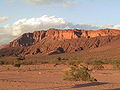
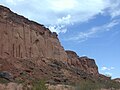
The park is in a basin between the Cerro Los Colorados to the west and the Sierra de Sañagasta to the east. The landscape is the result of erosion by water and wind in a desert climate, with large ranges in temperature - high heat by day and low temperature at night, with torrential rain in summer and strong wind in spring.
Features
The park includes:
- The dry bed of the Ischigualasto, have been found here;
- The Talampaya gorge and its rock formations with walls of the Talampaya Formationof up to 143 metres (469 ft) high, narrowing to 80 metres (262 ft) at one point;
- The remains of indigenous peoples' settlements, such as the petroglyphs of the Puerta del Cañón;
- A botanical garden of the local flora at the narrow point of the canyon;
- Regional fauna, including guanacos, hares, maras, foxes and condors.
Gallery
-
 Parque Nacional de Talampaya
 -
 Talampaya canyon entrance
 -
 Petroglyphs
 -
 Parque Nacional Talampaya
 -
 Tour buses at the park
 -
 Rhea
Rhea -
 The wall


References
- ^ Dellafiore, Claudia, Southern South America: Southern Argentina, stretching northward (NT0802), WWF: World Wildlife Fund, retrieved 2017-04-12
External links
Wikimedia Commons has media related to Talampaya.
Wikivoyage has a travel guide for Talampaya National Park.
| Northwest | ||
|---|---|---|
| Mesopotamia |
| |
| Cuyo | ||
| Pampas | ||
| Patagonia | ||
| Authority control databases: National |
|---|