
Halligen
 North Frisian and Danish Wadden Sea Islands with Halligen (darker green) | |
 | |
| Geography | |
| Coordinates | 54°34′N 8°39′E / 54.567°N 8.650°E |
| Total islands | 13 |
| Administration | |
Germany, Denmark | |
| Demographics | |
| Population | about 291 |
The Halligen (German, singular Hallig, German: ).
The name is cognate to Old-English halh, meaning "slightly raised ground isolated by marsh".[3] The very existence of the halligen is a result of frequent floods and poor coastal protection. The floods were much more common in the Middle Ages and coastal protection was much poorer.
The halligen have areas ranging from 7 to 956 ha, and are often former parts of the mainland, separated therefrom by storm tide erosion. Some are parts of once much bigger islands sundered by the same forces.[4] Some, owing to sediment deposition, have actually grown together to form larger ones. Langeneß (or Langeness) includes a former island by that same name, and two others that were called Nordmarsch and Butwehl.
Dwellings and commercial buildings are built upon metre-high, man-made mounds, called
Not very many people live on the halligen. Their livelihoods are mainly based on
The halligen are to be found in the
In the west the German halligen are protected from the open sea by the North Frisian Barrier Island.
-
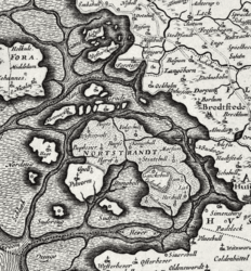 The Halligen area around 1650 on a map by Johannes Mejer
 -
 The North Frisian Halligen area around 1850, showing changes
 -
 A hallig: thesalt meadowin bloom
 -
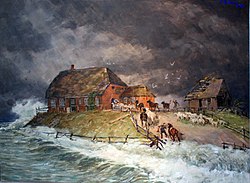 Alexander Eckener: Warft of a Hallig during a storm tide, 1906
 -
 Dagebüll hallig railway, flooded, in 1984


.jpg)
List of Halligen
Currently, there are 10 halligen in Germany. The following list does not include formerly existing Halligen that have either vanished or merged with current halligen or the mainland:
- Narrow gauge railway connection to Oland (over causeway).
- Hooge– 574 ha, 10 Warften, about 120 inhabitants.
- Gröde – 277 ha, 2 Warften, 11 inhabitants.
- Nordstrandischmoor; 175 ha, 4 Warften, 18 inhabitants. One-room schoolhouse. Narrow gauge railway connection to mainland.
- Oland– 96 ha, 1 Warft, about 30 inhabitants. Narrow gauge railway connection to mainland and Langeneß.
- Süderoog – 60 ha, 1 Warft, 2 inhabitants.
- Südfall – 50 ha, 1 Warft, bird sanctuary.
- Hamburger Hallig – 50 ha, 2 Warften, uninhabited, inn occupied in summer, joined to the mainland by a 4 km-long causeway and a polder.
- Norderoog – 9 ha, no Warften, bird sanctuary tended year-round.
- Habel – 3.6 ha, 1 Warft, uninhabited, bird sanctuary occupied in summer.
On the Danish side, one still exists:
Also Danish Mandø used to be a hallig, but it has dikes today. The German peninsula and former island of Großer Werder on the Baltic Sea coast is also nicknamed "Baltic Hallig" (Ostsee-Hallig) due to its remote situation and appearance.
See also
References
- ^ Walker, Tamsin (2020-03-01). "The German islands that regularly vanish beneath the sea". Deutsche Welle (www.dw.com). Archived from the original on 2021-02-24. Retrieved 2021-03-20.
- ^ Walker, Tamsin (2020-01-14). "Will Germany's vanishing Hallig islands survive rising seas?". Deutsche Welle (www.dw.com). Archived from the original on 2021-02-24. Retrieved 2021-03-20.
- word hal, meaning "salt" is less likely.
- ^ Walker, Tasmin (2019-12-23). "Could flooding be a cure for rising seas?". Deutsche Welle (www.dw.com). Archived from the original on 2021-01-14. Retrieved 2021-03-20.
- S2CID 20754802.
- OCLC 20217629.
External links
- George P. Marsh. Boston: Gould and Lincoln.
- Breitenbach, Dagmar (2012-04-02). "Hallig Hooge: Almost an island". Deutsche Welle (www.dw.com). Archived from the original on 2016-10-11. Retrieved 2021-03-20.
- Election campaign on the North Sea coast (Television production). Deutsche Welle. 2017-09-13. Archived from the original on 2017-09-21.
- Walker, Tamsin (2019-09-26). "Living Planet: Hallig Islands" (mp3). Deutsche Welle (www.dw.com) (Radio broadcast report). Archived from the original on 2019-09-27. Retrieved 2021-03-20.
- "Island Life 03 - The Halligen" (video). youtube.com. Deutsche Welle / euromaxx. 2010-07-21. Archived from the original on 2021-12-13. Retrieved 2021-03-20.
- Shebab, Ibrahim (2020-01-14). "The German island with a population of 16" (Video). youtube.com (Video report, German audio with English subtitles). BBC Reel. Archived from the original on 2021-12-13. Retrieved 2021-03-20.
- "Wadden Sea and Hallig Islands of Schleswig-Holstein Biosphere Reserve, Germany". UNESCO. Oct 2018. Archived from the original on 2020-10-22. Retrieved 2021-03-27.
| West Frisian Islands (Netherlands) |
|  | |||||
|---|---|---|---|---|---|---|---|
| East Frisian Islands (Germany) |
| ||||||
| Heligoland Bight (Germany) | |||||||
| North Frisian Islands (Germany) |
| ||||||
| Danish Wadden Sea Islands (Denmark) |
| ||||||
| International | |
|---|---|
| National | |