
Sylt
Sylt (German pronunciation:
54°54′N 8°20′E / 54.900°N 8.333°E
Native name: Söl, Sild | |
|---|---|
Danes | |
| Additional information | |
| Official website | www |
Geography


With 99.14 square kilometres (38.28 square miles), Sylt is the fourth-largest
The island's shape has constantly shifted over time, a process which is still ongoing today. The northern and southern
The island in its current form has only existed for about 400 years. Like the mainland geestland, it was formed of moraines from the older ice ages, thus being made up of a till core, which is now apparent in the island's west and centre by the cliff, dunes and beach. This sandy core began to erode as it was exposed to a strong current along the island's steep basement when the sea level rose 8000 years ago. During the process, sediments were accumulated north and south of the island. The west coast, which was originally situated 10 kilometres (6 miles) off today's shore, was thus gradually moved eastward, while at the same time the island began to extend to the north and south. After the ice ages, marshland began to form around this geestland core.
In 1141, Sylt is recorded as an island, yet before the
In addition to the constant loss of land, the inhabitants during the
Records of the annual land loss exist since 1870. According to them, Sylt lost an annual 0.4 metres (16 inches) of land in the north and 0.7 metres (28 inches) in the south from 1870 to 1951. From 1951 to 1984, the rate increased to 0.9 metres (35 inches) and 1.4 metres (55 inches) respectively, while shorelines at the island's very edges at Hörnum and List are even more affected.[3]
Severe storm surges of the last decades have repeatedly endangered Sylt to the point of breaking in two, e.g. Hörnum was temporarily cut off from the island in 1962. Part of the island near Rantum which is only 500 m wide is especially threatened.


Measures of protection against the continuous erosion date back to the early 19th century when groynes of wooden poles were constructed. Those were built at right angles into the sea from the coast line. Later they were replaced by metal and eventually by armoured concrete groynes. The constructions did not have the desired effect of stopping the erosion caused by crossways currents. "Leeward erosion", i.e. erosion on the downwind side of the groynes prevented sustainable accumulation of sand.
In the 1960s, breaking the power of the sea was attempted by installing tetrapods along the groyne bases or by putting them into the sea like groynes. The four-armed structures, built in France and many tons in weight, were too heavy for Sylt's beaches and were equally unable to prevent erosion. Therefore, they were removed from the Hörnum west beach in 2005.[5]
Since the early 1970s, the only effective means so far has been flushing sand onto the shore. Dredging vessels are used to pump a mixture of sand and water to a beach where it is spread by bulldozers. Thus storm floods would only erase the artificial accumulation of sand, while the shoreline proper remains intact and erosion is slowed down.[6] This procedure incurs considerable costs. The required budget of an annual €10 million is currently provided by federal German, Schleswig-Holstein state and EU funds. Since 1972, an estimated 35.5 million cubic metres of sand have been flushed ashore and dumped on Sylt. The measures have so far cost more than €134 million in total, but according to scientific calculations they are sufficient to prevent further loss of land for at least three decades, so the benefits for the island's economic power and for the economically underdeveloped region in general would outweigh the costs.[7] In the 1995 study Klimafolgen für Mensch und Küste am Beispiel der Nordseeinsel Sylt (Climate impact for Man and Shores as seen on the North Sea island Sylt), it reads: "Hätte Sylt nicht das Image einer attraktiven Ferieninsel, gäbe es den Küstenschutz in der bestehenden Form gewiss nicht" (If Sylt did not have the image of an attractive holiday island, coastal management in its current form would certainly not exist).[8]
The enforcement of a natural reef off Sylt is being discussed as an alternative solution. A first experiment was conducted from 1996 to 2003.[9] A sand drainage as being successfully used on Danish islands is not likely to work on Sylt owing to the underwater slope here.[10]
In parallel to the ongoing sand flushing, the deliberate demolition of groynes has begun amid great effort at certain beach sections where they were proven largely ineffective. This measure also terminated the presumably most famous groyne of Sylt, Buhne 16 – the namesake of the local naturist beach.
A number of experts, however, fears that Sylt will still have to face considerable losses of land until the mid 21st century. The continuous
The
Also the grazing of sheep on the sea dikes and heaths of Sylt eventually serves coastal management, since the animals keep the vegetation short and compress the soil with their hooves. Thus they help create a denser dike surface, which in case of storm surges provides less area for the waves to impact.
Flora and fauna

The
The ample
With several thousand individuals in the dune belt of Sylt, the natterjack toad, endangered in Germany, has one of Germany's largest populations here. Their spawning places are wet dune slacks and shallow, short-lived pools. For a habitat they prefer sandy areas with vegetation, but the species has also been observed on the top of the Uwe Dune. The main threat for this species on Sylt is road traffic.[13]
The many
Regarding land mammals, there is no significant difference from the neighbouring areas of mainland Nordfriesland. Primarily European hare, rabbit and roe deer can be found and are also hunted as game on the island. When the island was connected to the mainland by the causeway, red fox and European badger also became common.
West of Sylt a breeding area of
Numerous associations and societies that care for the exploration and the protection of endangered animals and plants have branches on Sylt. Among them are the
Climate
On Sylt, a
The annual mean temperature is 8.5 °C. The annually averaged wind speed measures 6.7 m/s, predominantly from western directions. The annual rainfall amounts to about 650 millimetres.
Sylt features an oceanic climate that is influenced by the Gulf Stream. On average, the winter season is slightly warmer than in mainland Nordfriesland. The summer season, however, is cooler despite longer sunshine periods. The yearly average sunshine period is greater than 4.4 hours per day with some years exceeding the average sunshine for all of Germany. Also precipitation is lower than on the mainland. This is due to the low relief of Sylt's shoreline where clouds are not able to accumulate and rain off.[17]
| Climate data for List (1961–1990 averages)
| |||||||||||||
|---|---|---|---|---|---|---|---|---|---|---|---|---|---|
| Month | Jan | Feb | Mar | Apr | May | Jun | Jul | Aug | Sep | Oct | Nov | Dec | Year |
| Daily mean °C (°F) | 1.0 (33.8) |
0.9 (33.6) |
2.7 (36.9) |
6.0 (42.8) |
10.8 (51.4) |
14.2 (57.6) |
15.7 (60.3) |
16.2 (61.2) |
13.9 (57.0) |
10.4 (50.7) |
6.1 (43.0) |
2.8 (37.0) |
8.4 (47.1) |
| Average precipitation mm (inches) | 57.3 (2.26) |
35.1 (1.38) |
44.9 (1.77) |
39.5 (1.56) |
41.5 (1.63) |
55.9 (2.20) |
62.1 (2.44) |
72.1 (2.84) |
82.5 (3.25) |
88.5 (3.48) |
94.3 (3.71) |
71.6 (2.82) |
745.3 (29.34) |
| Mean monthly sunshine hours | 46.7 | 75.3 | 120.1 | 179.3 | 243 | 246.5 | 230.7 | 228.1 | 147.8 | 98.3 | 55.6 | 42.6 | 1,714 |
| Source: German Meteorological Service[18] | |||||||||||||
| Climate data for List, (1990–2014 averages) | |||||||||||||
|---|---|---|---|---|---|---|---|---|---|---|---|---|---|
| Month | Jan | Feb | Mar | Apr | May | Jun | Jul | Aug | Sep | Oct | Nov | Dec | Year |
| Daily mean °C (°F) | 2.3 (36.1) |
2.2 (36.0) |
4.3 (39.7) |
8.2 (46.8) |
12.1 (53.8) |
14.8 (58.6) |
17.7 (63.9) |
18.0 (64.4) |
15.0 (59.0) |
10.8 (51.4) |
6.5 (43.7) |
3.3 (37.9) |
9.6 (49.3) |
| Average precipitation mm (inches) | 49.9 (1.96) |
38.4 (1.51) |
33.5 (1.32) |
31.1 (1.22) |
37.8 (1.49) |
47.6 (1.87) |
54.3 (2.14) |
84.8 (3.34) |
77.6 (3.06) |
85.1 (3.35) |
69.3 (2.73) |
61.8 (2.43) |
670.8 (26.41) |
| Mean monthly sunshine hours | 46.74 | 67.1 | 129.2 | 179.5 | 221.1 | 209.8 | 215.3 | 189.8 | 137.9 | 97.2 | 51.1 | 42.6 | 1,587.2 |
| Source: WeatherOnline.co.uk[19] | |||||||||||||
| Climate data for List, (2019-present averages) | |||||||||||||
|---|---|---|---|---|---|---|---|---|---|---|---|---|---|
| Month | Jan | Feb | Mar | Apr | May | Jun | Jul | Aug | Sep | Oct | Nov | Dec | Year |
| Daily mean °C (°F) | 6.3 (43.3) |
5.6 (42.1) |
5.6 (42.1) |
8.4 (47.1) |
10.6 (51.1) |
16.9 (62.4) |
15.8 (60.4) |
18.7 (65.7) |
14.9 (58.8) |
11.1 (52.0) |
6.4 (43.5) |
6.1 (43.0) |
10.5 (51.0) |
| Average precipitation mm (inches) | 62.9 (2.48) |
99.1 (3.90) |
25.9 (1.02) |
15.0 (0.59) |
14.0 (0.55) |
63.2 (2.49) |
79.7 (3.14) |
70.4 (2.77) |
151.9 (5.98) |
125.6 (4.94) |
124.8 (4.91) |
38.9 (1.53) |
871.4 (34.3) |
| Mean monthly sunshine hours | 33.6 | 52.6 | 194.3 | 239.2 | 268.0 | 277.1 | 187.1 | 250.6 | 153.3 | 101.7 | 30.0 | 38.1 | 1,825.6 |
| Source: WeatherOnline.co.uk[20] | |||||||||||||
| Climate data for Sylt | |||||||||||||
|---|---|---|---|---|---|---|---|---|---|---|---|---|---|
| Month | Jan | Feb | Mar | Apr | May | Jun | Jul | Aug | Sep | Oct | Nov | Dec | Year |
| Average sea temperature °C | 4.7 |
3.7 |
4.6 |
8.0 |
12.1 |
16.0 |
18.4 |
19.1 |
17.2 |
13.5 |
10.0 |
6.5 |
11.2 |
| Mean daily daylight hours | 8.0 | 10.0 | 12.0 | 14.0 | 16.0 | 17.0 | 16.0 | 15.0 | 13.0 | 11.0 | 9.0 | 8.0 | 12.4 |
| Average Ultraviolet index | 0 | 1 | 2 | 4 | 5 | 6 | 7 | 6 | 4 | 2 | 1 | 0 | 3 |
| Source: Weather Atlas[21] | |||||||||||||
Settlements
.jpg)
.jpg)
Sylt is divided into two administrative bodies: the
A referendum held in May 2008 resulted in a merger of the Sylt-Ost municipality with the town of Westerland on 1 January 2009.[23] Various interest groups hope to merge every island municipality into one governing body.[24]
Settlements along the west coast
Six municipalities are situated along the west coast of Sylt.
After the complete destruction of the village Eidum by a storm surge on 1 November 1436, the survivors founded a new village northeast of their old home: Westerland. The name was first recorded in 1462. In 1865, a seaside spa was founded and, 50 years later, Westerland was granted town privileges. In 1949, it was officially recognised as a health resort. In 2007, the town numbered 9,072 citizens.
South of Westerland, the island extends for about 15 km in the form of a spit, until it is cut by the Hörnumtief tidal creek that runs through the Wadden Sea mudflats east of Sylt. Here is the location of
Hörnum on the island's southern headland is the youngest village. It was founded shortly after 1900, although the uninhabited southern tip of Sylt was said to serve as refuge for pirates and fishermen. The name Budersand in the area emanates from that custom, marking a great dune where booths (German: Buden) stood in former times to serve as shelters.[25] This southern headland, called Odde, is marked by continuous loss of land. Each year great amounts of sand are washed away by storm floods and coastal management has not yet seen sustainable effects in the area, so that further losses have to be expected.
Sylt-Ost
Sylt-Ost (East Sylt) is a former municipality which was formed in 1970 out of several small villages on the Nössehalbinsel of Sylt. The population (as of 2000) was 5,500. The villages included Tinnum, Munkmarsch, Archsum, Morsum and Keitum. In 2009, Sylt-Ost merged with Westerland and Rantum to form Gemeinde Sylt.
History
Geographically, Sylt was originally part of
During the 17th and 18th century,

Today, Sylt is mainly a tourist destination, famous for its sandy beaches and healthy climate. The 40 km-long (25 mi) west beach has a number of surf schools and also a nude section. The
The Freikörperkultur and nude bathing
At the beginning of the 20th century, the bathing beaches on Sylt were
Culture
Sylt is a part of the
Today, only a small fraction of the population still speak Söl'ring. A law to promote the language (Friesisch-Gesetz) was passed in 2004. The northernmost part of the island, Listland, was traditionally Danish-speaking.
As in many areas in Schleswig-Holstein on New Year's Eve, groups of children go masked from house to house, reciting poems. This is known as "Rummelpottlaufen", and as a reward, children receive sweets or money.
Sylt also features many Frisian-style houses with thatched roofs.
Since the mid-18th century, the vowel in the name of the island has been represented as "y" for unknown reasons, while older spellings are Sildt and Silt, allegedly derived from Danish sild "herring",[30] or maybe related to English silt.
Sylt is mentioned in a pangram, a sentence that uses every letter in the German alphabet, including every umlaut (ä, ö, ü) plus the ß: Victor jagt zwölf Boxkämpfer quer über den großen Sylter Deich ("Victor chases twelve boxers across the Great Levee of Sylt").
Sylt in painting
Among the first painters who discovered Sylt as a theme were Eugen Dücker and Eugen Bracht. Franz Korwan followed them. The painter Andreas Dirks was born in Tinnum on Sylt in 1865. He studied at the Düsseldorf Art Academy and in Weimar, lived in Düsseldorf since 1895, accepted a professorship there in 1916 and at the same time maintained a studio in Westerland. Ulrich Schulte-Wülwer described him as "... the strongest artistic talent that the island has produced". Carl Arp came to Sylt in 1903. Painters like Emil Nolde, Erich Heckel, Anita Rée and Albert Aereboe moved to Sylt. Contemporary artists include the painters and sculptors Rainer Fetting and Ingo Kühl, who live in Berlin and on Sylt.
-
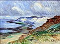
 Morsum-Kliff), 1897, Oil on canvas 61,5 × 50,5 cm
 -
 Franz Korwan Winter auf Sylt, Oil on wood 24 × 38 cm, without year
 -
 Carl Arp Küstenlandschaft auf Sylt (Morsumkliff) 1905, Oil on canvas 47,5 × 59,5 cm, Museumsberg Flensburg
 -
 Wenzel Hablik Landschaft auf Sylt 1910, Oil on canvas, Museumsberg Flensburg
 -
 Andreas Dirks Munkmarschener Hafenansicht auf Sylt, 1922, Oil on canvas
 -
 Anita Rée Die Oase in Kampen, 1932/33, Watercolor 39 × 49 cm
 -
 Ingo Kühl Haus am Watt, 2015, Oil on canvas 150 × 200 cm


_anagoria.JPG)

.jpg)


Notable people

- Dirk Meinerts Hahn (born 1804 in Westerland, Sylt – 1860) best known as the captain of the ship Zebra that he captained to South Australia
- Cornelius Jensen (1814 in Sylt – 1886) a Danish sea captain for 20 years; arriving in San Francisco in 1848, he became a rancher, a vintner and served as a California politician.
- Henriette Hirschfeld-Tiburtius (1834 in Sylt – 1911) the first female dentist in Germany
- Gustav Jenner (1865 in Keitum – 1920) a German composer, conductor and musical scholar and the only formal composition pupil of Johannes Brahms
- Hermann von der Lieth-Thomsen (1867–1942 in Sylt) a German military aviation pioneer, lived in Sylt from 1928
- Margarete Boie (1880 – 1946) a German author in the 1920s incorporating the history, landscape and people of Sylt
- Anita Rée (1885 – 1933) a German-Jewish painter, lived and worked here
- atrocities. After the war Reinefarth became the mayor of Westerland and member of the Schleswig-Holstein Landtag
- Boy Lornsen (1922 in Keitum – 1995) a German sculptor and author of children's literature
- Dora Heldt (born Bärbel Schmidt, 1961 in Sylt) a German author
Transport
Sylt is connected to the German mainland by the Hindenburgdamm, a causeway with a railway line on top. The passenger trains connect Westerland (Sylt) to Niebüll or Klanxbüll, and the Deutsche Bahn's "Syltshuttle" as well as RDC's "Autozug Sylt", allow the transfer of cars and trucks between Westerland and Niebüll. There are also car ferry services to the nearby Danish island of Rømø, which offers a road connection to the mainland. Sylt Airport at Westerland serves the region.
In other media
The island was used during the filming of The Ghost Writer, as an alternate location for Martha's Vineyard, due to the film's director, Roman Polanski being unable to travel to the United States, due to an outstanding arrest warrant for rape. The ferry between the islands of Sylt and Rømø features prominently in the film.
See also
- Island portal
 Germany portal
 Denmark portal
- Üüs Söl’ring Lön’, insular anthem
- Heinz Reinefarth, a Nazi-German military officer. The "Butcher of Warsaw" became mayor of Westerland after World War II.
- St. Niels
- Uthlande
References
- ^ Technical University Berlin. Archived from the originalon 28 December 2008. Retrieved 28 September 2008.
- ^ University of Kiel. Archived from the original(PDF) on 6 October 2007. Retrieved 28 September 2008.
- ^ Landesamt für den Nationalpark Schleswig-Holsteinisches Wattenmeer, Umweltbundesamt, ed. (1998). Umweltatlas Wattenmeer (Wadden Sea environmental Atlas) (in German). Vol. I – Nordfriesisches und Dithmarscher Wattenmeer. Stuttgart. p. 38.
{{cite book}}: CS1 maint: location missing publisher (link) - PMID 27877792.

- ^ Witte, J.-O.; Kohlhase, Sören, J. Radomski, P. Fröhle. "Fallstudie Sylt" (PDF) (in German). University of Rostock. Archived from the original on 10 August 2007.
{{cite web}}: CS1 maint: multiple names: authors list (link) CS1 maint: unfit URL (link) - ^ Von Liebermann, Nicole. "Küstenschutz: Bisherige und zukünftige Maßnahmen" (PDF) (in German). Technical University of Harburg. Archived from the original on 11 June 2007.
{{cite web}}: CS1 maint: unfit URL (link) - ^ Daschkeit, Achim; Horst Sterr. "Küste, Ökologie und Mensch, Integriertes Küstenmanagement als Instrument nachhaltiger Entwicklung". In Bernhard Glaeser (ed.). Edition Humanökologie (PDF). Vol. 2. Deutsche Gesellschaft für Humanökologie. Archived from the original (PDF) on 27 November 2009. Retrieved 28 September 2008.
- ISBN 978-3-540-42569-4.
- ^ Bleck, Matthias. "Funktionale Bemessung künstlicher Riffe für aktiven und sanften Küstenschutz" (PDF). Stiftung deutscher Küstenschutz.[dead link]
- ^ Newig, J. "Sand auf Sylt" (PDF). University of Kiel. Archived from the original (PDF) on 5 July 2010. Retrieved 28 September 2008.
- ^ a b "Interessantes über die Braderuper Heide" (in German). Naturschutzgemeinschaft Sylt. Archived from the original on 17 February 2012.
{{cite web}}: CS1 maint: unfit URL (link) - ^ "Morsum-Kliff" (in German). Naturschutzgemeinschaft Sylt. Archived from the original on 17 February 2012.
{{cite web}}: CS1 maint: unfit URL (link) - ^ Klinge, Andreas (2003). "Die Amphibien und Reptilien Schleswig-Holsteins, Rote Liste" (PDF). 3rd version (in German). Schleswig-Holstein State Office for Nature and Environment. Archived (PDF) from the original on 19 July 2011. Retrieved 28 September 2008.
{{cite journal}}: Cite journal requires|journal=(help) - ISBN 3-490-16418-0.
- ^ "Tourimusstatistik 2005" (PDF) (in German). Town of Westerland. Archived from the original (PDF) on 15 August 2009. Retrieved 28 September 2008.
- ^ "List auf Sylt (climate chart)". Bernhard Mühr. 1 June 2007. Archived from the original on 11 October 2008. Retrieved 28 September 2008.
- ^ "Das Wetter auf Sylt: viel Sonne und eine frische Brise" [The Weather on Sylt: A lot of Sunshine and a fresh Breeze]. Zeit Reisen (in German). Retrieved 23 October 2012.
- ^ "Frei zugängliche Klimadaten" (in German). German Meteorological Service.
- ^ "CLimate Robot List/Sylt". WeatherOnline.co.uk. Archived from the original on 4 March 2016. Retrieved 17 September 2015.
- ^ "CLimate List/Sylt". dwd.de. Retrieved 13 August 2020.
- ^ "Sylt, Germany – Monthly weather forecast and Climate data". Weather Atlas. Retrieved 25 January 2019.[permanent dead link]
- ^ "Orte, Städte, Gemeinden im Landkreis Nordfriesland" (in German). Deutschland auf einen Blick. Archived from the original on 30 September 2008. Retrieved 29 September 2008.
- Sylter Rundschau (in German). Schleswig-Holsteinischer Zeitungsverlag. 26 May 2008. Archived from the original on 16 February 2012.)
{{cite news}}: CS1 maint: unfit URL (link - Sylter Rundschau (in German). Schleswig-Holsteinischer Zeitungsverlag. 27 May 2008. Archived from the original on 16 February 2012.)
{{cite news}}: CS1 maint: unfit URL (link - ^ Pahl, Max (1983). Hörnum. Heimat am Horn – Querschnitt und Streifzüge durch Geschichte, Leben und Landschaft des Nordseebades Hörnum auf Sylt (in German). Lunden: Verlagsdruckerei Schallhorn.
- ^ "First World War.com Day by day". First World War.com. Archived from the original on 25 March 2016. Retrieved 27 March 2016.
- ^ "Auschwitz: Inside the Nazi State. Auschwitz 1940–1945. Liberation & Revenge". PBS. Archived from the original on 27 August 2017. Retrieved 15 September 2017.
- ^ "PWA WORLD WINDSURFING TOUR: Detail".
- ^ Loxton, Richard (2019). "Why Germany's nudist culture remains refreshing". Bonn: Deutsche Welle. Retrieved 24 July 2021.
- ^ J. Booysen (1828), Beschreibung der insel Silt in geographischer, statistischer und historischer Rücksicht, pp. 5–6
External links
![]() Sylt travel guide from Wikivoyage
Sylt travel guide from Wikivoyage
| West Frisian Islands (Netherlands) |
|  | |||||
|---|---|---|---|---|---|---|---|
| East Frisian Islands (Germany) |
| ||||||
| Heligoland Bight (Germany) | |||||||
| North Frisian Islands (Germany) |
| ||||||
| Danish Wadden Sea Islands (Denmark) |
| ||||||
| International | |
|---|---|
| National | |