Hockley Valley Provincial Nature Reserve
| Hockley Valley Provincial Nature Reserve | |
|---|---|
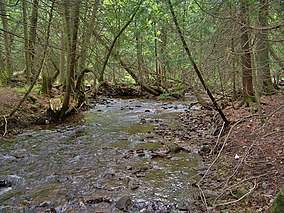
 A Nottawasaga River tributary within the reserve. | |
| Location | Ontario, Canada |
| Nearest city | Mono |
| Coordinates | 43°59′6″N 80°3′44″W / 43.98500°N 80.06222°W |
| Area | 3.78 km2 (1.46 sq mi) |
| Established | 1989 |
| Governing body | Ontario Parks |
| www | |
Hockley Valley Provincial Nature Reserve is a nature reserve located on the Niagara Escarpment within the township of Mono, Ontario, Canada. It is managed by Ontario Parks. Approximately 80% of the Cannings Falls Area of Natural and Scientific Interest is within the borders of the park; land acquisitions are planned to encompass it entirely.[1][2] The Bruce Trail links the reserve to other protected areas of the Niagara Escarpment.
Landform
The
Queenston Shale.[1]
Flora and fauna
Within the reserve, 417 species of
northern long-eared bat, the nationally vulnerable Louisiana waterthrush and the northern brook lamprey, as well as the nationally threatened Jefferson salamander.[2]
Activities
Recreation in the park is limited. Due to the park's designation as a nature reserve, permitted activities are limited to
snowshoeing; no visitor facilities are present or planned.[2]
References
- ^ Ontario Ministry of Natural Resources. 2008-06-27. Archived from the originalon 2009-06-08. Retrieved 2009-06-07.
- ^ a b c d "Hockley Valley Park Management Plan" (PDF). Ontario Parks. 2005-01-28. Archived from the original (PDF) on 2011-06-06. Retrieved 2009-06-07.
- ISBN 0-8020-2755-5.
- ^ "Parks in Dufferin County". Niagara Escarpment Commission. 2007-01-03. Archived from the original on 2009-07-01. Retrieved 2009-06-12.
- ^ "Species Profile - Butternut". Species at Risk Public Registry. 2009-05-13. Archived from the original on 2013-06-10. Retrieved 2009-06-13.


