
Kończyce Wielkie
Kończyce Wielkie | ||
|---|---|---|
Village | ||
 Palace in Kończyce Wielkie | ||
|
Car plates SCI | | |
ⓘ is a village in Gmina Hażlach, Cieszyn County in Silesian Voivodeship, southern Poland, near the border with the Czech Republic.
History
In 2004 and 2005 in the village the oldest traces of Homo erectus in Poland were found, dated 800 000 years old.[1]
The village in the historical region of
Politically the village belonged initially to the
The village could have become a seat of a Catholic
After the
After World War I, the fall of Austria-Hungary, the Polish–Czechoslovak War and the division of Cieszyn Silesia in 1920, it became a part of Second Polish Republic and was transferred to Cieszyn County. It was then annexed by Nazi Germany at the beginning of World War II. After the war it was restored to Poland.
Geography
Kończyce Wielkie lies in the southern part of Poland, 10 km (6 mi) north of the county seat, Cieszyn, 28 km (17 mi) west of Bielsko-Biała, 55 km (34 mi) south-west of the regional capital Katowice, and 5 km (3.1 mi) east of the border with the Czech Republic.
The village is situated in
Places adjacent to Kończyce Wielkie | |
|---|---|
Landmarks
There is a wooden
Gallery
-
 Saint Michael Archangel parish church
 -
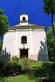 Chapel of the Providence of God


See also
Footnotes
- ^ Uniwersytet Śląski w Katowicach (21 October 2010). "Odkrycie najstarszych śladów obecności człowieka na terenie Polski" (in Polish). Archived from the original on 22 October 2014. Retrieved 26 October 2010.
- ISBN 978-83-926929-3-5.
- ^ Schulte, Wilhelm (1889). Codex Diplomaticus Silesiae T.14 Liber Fundationis Episcopatus Vratislaviensis (in German). Breslau: Josef Max & Comp.
- ^ "Liber fundationis episcopatus Vratislaviensis" (in Latin). Retrieved 13 July 2014.
- ^ Ptaśnik, Jan (1913). Monumenta Poloniae Vaticana T.1 Acta Camerae Apostolicae. Vol. 1, 1207-1344. Cracoviae: Sumpt. Academiae Litterarum Cracoviensis. p. 366.
- ^ "Registrum denarii sancti Petri in archidiaconatu Opoliensi sub anno domini MCCCCXLVII per dominum Nicolaum Wolff decretorum doctorem, archidiaconum Opoliensem, ex commissione reverendi in Christo patris ac domini Conradi episcopi Wratislaviensis, sedis apostolice collectoris, collecti". Zeitschrift des Vereins für Geschichte und Alterthum Schlesiens (in German). 27: 361–372. 1893. Retrieved 21 September 2019.
- ISBN 978-83-85572-00-8.
- ^ Piątkowski, Kazimierz (1918). Stosunki narodowościowe w Księstwie Cieszyńskiem (in Polish). Cieszyn: Macierz Szkolna Księstwa Cieszyńskiego. pp. 273, 290.
References
- 700 lat Hażlacha i Kończyc Wielkich. Hażlach, Kończyce Wielkie: Gmina Hażlach. 2005. ISBN 978-83-922804-0-8.
- Cicha, Irena; Kazimierz Jaworski; Bronisław Ondraszek; Barbara Stalmach; Jan Stalmach (2000). Olza od pramene po ujście. Český Těšín: Region Silesia. ISBN 978-80-238-6081-8.
- Londzin, Józef (1932). Kościoły drewniane na Śląsku Cieszyńskim. Cieszyn: Dziedzictwo błog. Jana Sarkandra. pp. 171–177. OCLC 297540848.
- Trzcionka, Wojciech (28 December 2007). "Pałac zamieni się w hotel". gazetacodzienna.pl. Archived from the original on 2 October 2011. Retrieved 30 December 2007.
- "The oldest human traces north of the Carpathians (Kończyce Wielkie 4, Poland)". 21 October 2010. Archived from the original on 1 February 2013.
Seat: Hażlach | ||
| Other villages | ||

