
Kozan, Adana
Kozan | |
|---|---|
District and municipality | |
 View from Kozan Castle | |
 Map showing Kozan District in Adana Province | |
 Kozan Location in Turkey | |
| Coordinates: 37°27′N 35°48′E / 37.450°N 35.800°E | |
| Country | Turkey |
| Province | Adana |
| Government | |
| • Mayor | Kazım Özgan (AKP) |
| Area | 1,903 km2 (735 sq mi) |
| Elevation | 120 m (390 ft) |
| Population (2022)[1] | 132,703 |
| • Density | 70/km2 (180/sq mi) |
| Time zone | UTC+3 (TRT) |
| Postal code | 01510 |
| Area code | 0322 |
| Website | www |
Kozan, formerly Sis (Armenian: Սիս), is a municipality and district of Adana Province, Turkey.[2] Its area is 1,903 km2,[3] and its population is 132,703 (2022).[1] It is 68 kilometres (42 miles) northeast of Adana, in the northern section of the Çukurova plain. The Kilgen River, a tributary of the Ceyhan, flows through Kozan and crosses the plain south into the Mediterranean. The Taurus Mountains rise up sharply behind the town.
Sis was the
The population of the city has grown rapidly in recent years, from 15,159 in 1960, to 54,451 in 1990, to 72,463 in 2007 and to 74,521 in 2009 (census figures).
Names
The oldest known name is Sis or Siskia. Under the Roman Empire, it was for a time named Flavias or Flaviopolis.[5] The Greek version of the older name, Σίσιον Sision, came back into use in the later Byzantine period.[6] In Armenian, it is called Sis Սիս or Sissu.
Kozan (
History
Middle Ages
_p153_-_VUE_DE_SIS.jpg)
_p197_TOWN_AND_FORTRESS_OF_SIS.jpg)
In 704, Sis was besieged by the
In 1266 Sis, the capital of
Ecclesiastical history
This section needs additional citations for verification. (May 2020) |
Sis had an important place in ecclesiastical history both the
In the Middle Ages, Sis was the religious center of Christian Armenians, until the Armenians moved the seat of Catholicos back to Vagharshapat (
Even prior to the Armenian Kingdom of Cilicia, Sis was an episcopal see and several names of bishops and patriarchs can be found in the literature:
- Alexander, later Bishop of Jerusalem and founder of the famous library of the Holy Sepulchre in the third century
- Nicetas, present at the First Council of Nicaea in 325
- John, who lived in 451;
- Andrew in the sixth century
- George (681)
- Eustratus, Patriarch of Antioch about 868
In 1441, Sis having fallen from its high estate, the Armenian clergy proposed to remove the see, and on the refusal of the Catholicos of the day,
The Catholicos of Sis (of the
Ottoman period
This section needs expansion. You can help by adding to it. (April 2015) |
In the Ottoman period, Kozan was in the
Modern
At the turn of the twentieth century, the town's population was 8,000, about 5,600 of which were Armenians.[13] They were all deported during the course of the Armenian genocide. Kozan was occupied by France between March 8, 1919 - June 2, 1920 during the Turkish War of Independence. After Turkey was declared a republic, Kozan was a province, compromising the districts of Kozan, Kadirli, Feke and Saimbeyli between 1923 and 1926.
Composition
There are 103
- Acarmantaş
- Ağlıboğaz
- Akarca
- Akçalıuşağı
- Akdam
- Akkaya
- Alapınar
- Andıl
- Arslanlı
- Arslanpaşa
- Aydın
- Ayşehoca
- Bağlar
- Bağözü
- Bağtepe
- Boztahta
- Bucakköy
- Bulduklu
- Çamdere
- Çamlarca
- Çanaklı
- Çandık
- Çelenuşağı
- Çobanpınarı
- Çokak
- Çukurören
- Çulluuşağı
- Cumhuriyet
- Çürüklü
- Damyeri
- Dikilitaş
- Dilekkaya
- Doğanalanı
- Duraluşağı
- Durmuşlu
- Düzağaç
- Enizçakırı
- Ergenuşağı
- Eskikabasakal
- Eskimantaş
- Faydalı
- Ferhatlı
- Gazi
- Gedikli
- Gökçeyol
- Gökgöz
- Görbeyaz
- Güneri
- Hacıbeyli
- Hacımirzalı
- Hacıuşağı
- Hamamköy
- İdemköy
- Ilıcaköy
- Işıkkaya
- Işıklı
- Kabaktepe
- Kahveli
- Kalkumaç
- Kapıkaya
- Karabucak
- Karacaoğlan
- Karacaören
- Karahamzalı
- Karanebili
- Kemer
- Kıbrıslar
- Kızıllar
- Kızlarsekisi
- Köseli
- Kuytucak
- Kuyubeli
- Kuyuluk
- Mahmutlu
- Mahyalar
- Marankeçili
- Minnetli
- Orçan
- Örendere
- Oruçlu
- Özbaşı
- Pekmezci
- Postkabasakal
- Salmanlı
- Şerifli
- Şevkiye
- Taş
- Tavşantepe
- Tepecikören
- Tufanlı
- Tufanpaşa
- Turgutlu
- Türkeli
- Turunçlu
- Varsaklar
- Velicanlı
- Yanalerik
- Yarımoğlu
- Yassıçalı
- Yeniköy
- Yukarıkeçili
- Yüksekören
- Zerdali
Kozan today
Today Kozan is a city surrounded by vineyards, gardens and groves of
Climate
Kozan has a
| Climate data for Kozan (1991–2020) | |||||||||||||
|---|---|---|---|---|---|---|---|---|---|---|---|---|---|
| Month | Jan | Feb | Mar | Apr | May | Jun | Jul | Aug | Sep | Oct | Nov | Dec | Year |
| Mean daily maximum °C (°F) | 14.6 (58.3) |
16.0 (60.8) |
19.5 (67.1) |
23.8 (74.8) |
28.8 (83.8) |
33.1 (91.6) |
35.8 (96.4) |
36.1 (97.0) |
33.5 (92.3) |
29.1 (84.4) |
22.2 (72.0) |
16.5 (61.7) |
25.8 (78.4) |
| Daily mean °C (°F) | 10.1 (50.2) |
11.2 (52.2) |
14.2 (57.6) |
17.9 (64.2) |
22.2 (72.0) |
26.1 (79.0) |
28.8 (83.8) |
29.2 (84.6) |
26.7 (80.1) |
22.9 (73.2) |
16.7 (62.1) |
11.9 (53.4) |
19.9 (67.8) |
| Mean daily minimum °C (°F) | 6.9 (44.4) |
7.4 (45.3) |
9.9 (49.8) |
12.9 (55.2) |
16.8 (62.2) |
20.2 (68.4) |
23.2 (73.8) |
23.7 (74.7) |
21.2 (70.2) |
18.3 (64.9) |
12.8 (55.0) |
8.5 (47.3) |
15.2 (59.4) |
| Average precipitation mm (inches) | 99.8 (3.93) |
81.62 (3.21) |
91.89 (3.62) |
80.61 (3.17) |
84.78 (3.34) |
46.94 (1.85) |
24.33 (0.96) |
22.98 (0.90) |
31.99 (1.26) |
43.63 (1.72) |
74.26 (2.92) |
112.22 (4.42) |
795.05 (31.30) |
| Average precipitation days (≥ 1.0 mm) | 7.8 | 7.5 | 8.3 | 8.2 | 7.0 | 4.8 | 2.7 | 2.5 | 3.3 | 4.8 | 4.8 | 8.2 | 69.9 |
| Average relative humidity (%)
|
56.2 | 56.5 | 58.7 | 62.4 | 62.3 | 62.0 | 63.8 | 63.6 | 57.6 | 51.0 | 49.9 | 56.8 | 58.4 |
| Source: NOAA[15] | |||||||||||||
Notable natives
- Nerses Balients (fl. early 14th century), Armenian ecclesiastical figure, politician, historian
- Grigor Khul (12th century), Armenian musician
- Soviet Armenia's Academy of Sciences
- Grigor Kyulyan (1912–1974), Armenian writer
- İmren Aykut (born 1940), Turkish female economist, trade unionist, politician and former government minister
Things to see
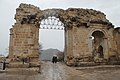
Today ruins of churches, convents, castles and palaces may be seen on all sides. The lofty castle and the monastery and church built by Leo II, and containing the coronation chair of the kings of
Gallery
-
 Street view of Kozan
 -
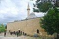 Grand Mosque of Kozan
 -

-
-
 Kozan Velicanlı District Sin Monastery
 -
-
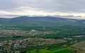 General view of Kozan


See also
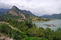
- Kozan Dam on the Kilgen River, 8 km (5 mi) north of Kozan
Notes
- ^ TÜİK. Retrieved 12 July 2023.
- ^ Büyükşehir İlçe Belediyesi, Turkey Civil Administration Departments Inventory. Retrieved 12 July 2023.
- ^ "İl ve İlçe Yüz ölçümleri". General Directorate of Mapping. Retrieved 12 July 2023.
- ^ "Castles.nl - Sis Castle". www.castles.nl. Retrieved 21 April 2018.
- 1911 Encyclopædia Britannica, s.v. 'Sis'
- ^ William Mitchell Ramsay, The Historical Geography of Asia Minor, p. 385
- ^ a b c Gould 2012.
- ^ a b c Chisholm, Hugh, ed. (1911). . Encyclopædia Britannica (11th ed.). Cambridge University Press.
- ^ Houshamadyan. "Maps - Vilayet of Adana - Sandjak of Sis :: Houshamadyan - a project to reconstruct Ottoman Armenian town and village life". www.houshamadyan.org. Retrieved 21 April 2018.
- ISSN 0041-4255.
- ^ Eberhard, Wolfram (1953). Nomads and Farmers in Southeastern Turkey, Problems of Settlement. Brill. p. 45.
- ^ Bearman et al. 2012.
- ^ Kévorkian, Raymond H. and Paul B. Paboudjian, Les Arméniens dans l’Empire Ottoman à la veille du génocide. Paris: Editions d’art et d’histoire, 1992, p. 292.
- ^ Mahalle, Turkey Civil Administration Departments Inventory. Retrieved 12 July 2023.
- ^ "World Meteorological Organization Climate Normals for 1991-2020 — Kozan". National Oceanic and Atmospheric Administration. Retrieved January 15, 2024.
References
- Chisholm, Hugh, ed. (1911). . Encyclopædia Britannica (11th ed.). Cambridge University Press.
 This article incorporates text from a publication now in the public domain: Herbermann, Charles, ed. (1913). "Flavias". Catholic Encyclopedia. New York: Robert Appleton Company.
Bibliography
- Gould, A.G. (2012). "Ḳōzān". In Bearman, P.; Bianquis, Th.; Bosworth, C.E.; van Donzel, E.; Heinrichs, W.P. (eds.). Encyclopaedia of Islam, Second Edition. E. J. Brill.
- Bearman, P.; Bianquis, Th.; Bosworth, C.E.; van Donzel, E.; Heinrichs, W.P., eds. (2012). "Ḳōzān-Og̲h̲ullari̇". Encyclopaedia of Islam, Second Edition. E. J. Brill.